METAR & TAF KOOA
Current METAR
Observed 13:15Z
KOOA 271315Z AUTO 22007KT 10SM CLR 29/26 A2980 RMK AO2 T02920255 PWINO
- Wind
- 220° @ 7 kt
- Visibility
- 10 SM
- Temp / Dew
- 29°C / 26°C
- Altimeter
- 29.80 inHg
- Clouds
- CLR
- Density alt
- 2,871 ft
- Ceiling
- Unlimited
- Rules
- VFR
Airport info & contacts
Manager on record, flight service, ARTCC, attendance schedule and pattern altitude — published by the FAA and refreshed every 28 days.
Location
- From city
- 9 NM SE
- VFR sectional
- CHICAGO
- ARTCC
- ZAU · CHICAGO
- NOTAM facility
- OOA (NOTAM-D)
Airport manager
- Name
- SHANE VANDE VOORT
- Phone
- 641-933-4316
- Address
- 2973 URBANA AVENUE, OSKALOOSA IA 52577
Flight service · Hours
- FSS FOD
- FORT DODGE1-800-WX-BRIEF
- Attendance
- MAY-SEP · MON - FRI · 0800-1800
- OCT-APR · MON - FRI · 0800-1700
- SAT - SUN · ON CALL
Frequencies
Tap any row to copy the frequency to your clipboard.
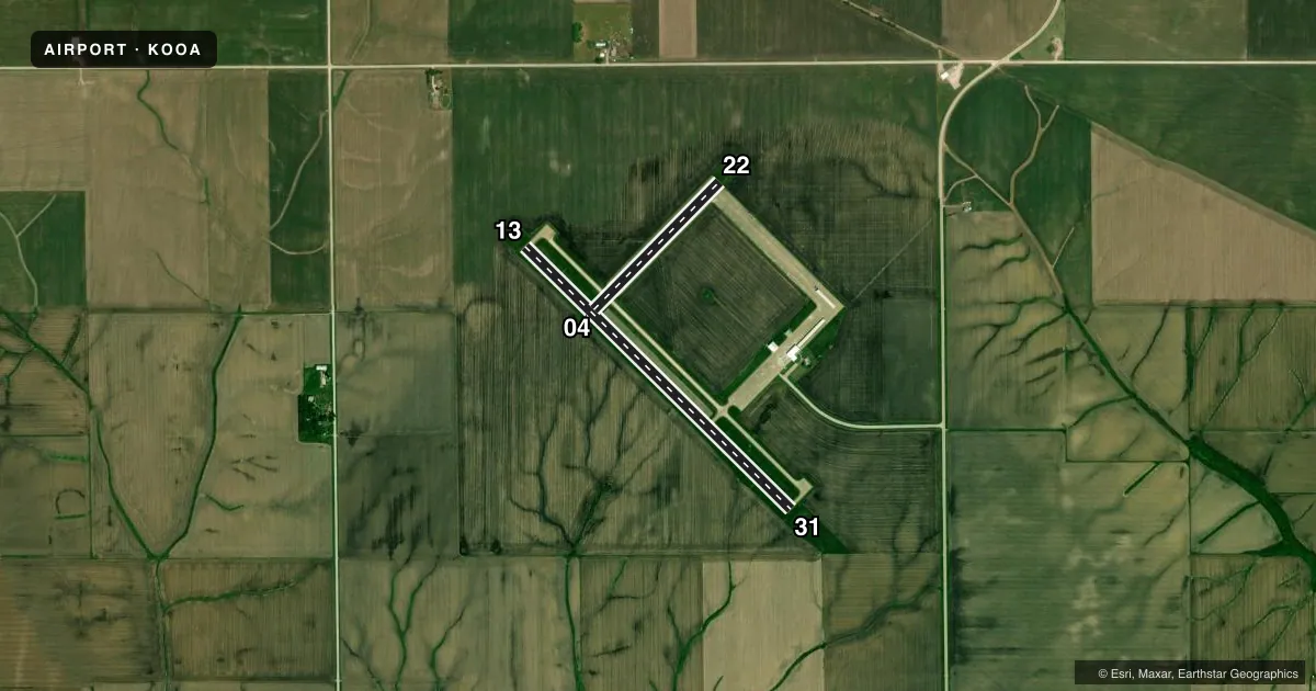
Runways & pattern
Full pagePattern entry · RWY 22
LEFT TRAFFIC| Runway | Heading (°M) | Length | Surface | Traffic |
|---|---|---|---|---|
| 13/31 | 134° / 314° | 4,012 ft | CONC | Standard L |
| 04/22Favored | 44° / 224° | 1,926 ft | CONC | Standard L |
Runway end performance
| End | TORA | TODA | ASDA | LDA | VGSI | Approach lights | Obstruction |
|---|---|---|---|---|---|---|---|
| 13 | — | — | — | — | PAPI 2-box left(3°) | — | — |
| 31 | — | — | — | — | PAPI 2-box left(3°) | — | — |
Declared distances in feet. TORA = takeoff run available, TODA = takeoff distance, ASDA = accelerate-stop, LDA = landing distance.
Airport sketch
Runways drawn to scale from FAA survey coordinates, rendered over satellite imagery. Not for navigation.
Approaches & charts
Services on the field
Fuel grades, oxygen, maintenance, ramp storage and lighting — as declared to the FAA by the airport operator.
Fuel & services
- Fuel
- 100LLA
- Oxygen (bottled)
- Not available
- Oxygen (bulk)
- Not available
- Airframe repair
- Major
- Power plant repair
- Major
- Other services
- INSTR,RNTL,SALES
Ramp & ground
- Transient storage
- Tie-down
- Hangar
- Landing fee
- No fee published
- Customs
- Not available
- Lighting schedule
- SEE RMK
- Beacon schedule
- SS-SR
- Beacon
- White / Green (civil land)(WG)
- Wind indicator
- Lighted
- Segmented circle
- No
Fuel & FBOs
Cheapest 100LL and Jet A on the field and nearby. Always confirm with the FBO before taxi.
Airport notes
Surface conditions, obstructions, local procedures, lighting outages and other notes published with each FAA cycle.
General notes
- FOR CD CTC CHICAGO ARTCC AT 630-906-8921.
Lighting notes
- ACTVT MIRL RWY 13/31; REIL RWY 13/31 - CTAF.
Other notes
- 3641-933-4316
VFR map & nearby airports
VFR sectional. Tap any ICAO chip to open that airport.
Key facts · KOOA
Answer card- ICAO
- KOOA
- Name
- OSKALOOSA MUNI
- Location
- OSKALOOSA, IOWA
- Elevation
- 840.2 ft MSL
- Traffic pattern altitude
- 1,840.2 ft MSL (1,000 AGL)
- Control tower
- Non-towered (use CTAF)
- Total runways
- 2
- Longest runway
- 13/31 · 4,012 ft
- Published ILS approaches
- 0
- Published frequencies
- 2
- Magnetic variation
- 1°
- Current flight rules
- VFR
- Current wind
- 220° at 7 kt
- Favored runway now
- RWY 22
Oskaloosa Muni sits in Oskaloosa, Iowa. Field elevation is 840.2 ft MSL. The airport has two concrete runways. The longest is runway 13/31 at 4,012 ft. There is no control tower. CTAF and UNICOM are both 122.8. No ILS approaches are published here.
For pattern work, the published pattern altitude is not listed. Use the standard 1,000 ft AGL pattern for light piston operations unless the current Chart Supplement or local traffic calls for something different. That puts you near 1,840 ft MSL based on the field elevation. Runway 13/31 has medium intensity lights. The runway end identifier lights on 13/31 are controlled by CTAF. That matters if you are arriving after dark.
Classic Aviation is on the field. It carries 100LL and Jet A. The airport remarks also say to contact Chicago ARTCC at 630-906-8921 for clearance delivery. The airport attendance schedule phone number is the same as Classic Aviation. If you are planning a first visit, brief the lighting setup, confirm the active runway on CTAF, then expect a non-towered environment with local traffic on 122.8.