METAR & TAF KTNU
Current METAR
Observed 17:15Z
KTNU 271715Z AUTO VRB05G11KT 9SM CLR A2975 RMK A01
- Wind
- VAR @ 5G11 kt
- Visibility
- 9 SM
- Temp / Dew
- —
- Altimeter
- 29.75 inHg
- Clouds
- CLR
- Density alt
- —
- Ceiling
- Unlimited
- Rules
- VFR
Airport info & contacts
Manager on record, flight service, ARTCC, attendance schedule and pattern altitude — published by the FAA and refreshed every 28 days.
Location
- From city
- 2 NM SE
- VFR sectional
- OMAHA
- ARTCC
- ZMP · MINNEAPOLIS
- NOTAM facility
- TNU (NOTAM-D)
Airport manager
- Name
- ETHAN NASALROAD
- Phone
- 641-792-1292
- Address
- BOX 986-2901 RUSTY WALLACE DRIVE, NEWTON IA 50208
Flight service · Hours
- FSS FOD
- FORT DODGE1-800-WX-BRIEF
- Attendance
- MON-FRI · 0730-1800
- SAT-SUN · 0800-1700
Frequencies
Tap any row to copy the frequency to your clipboard.
Runways & pattern
Full pagePattern entry · RWY 32
LEFT TRAFFICRunway end performance
| End | TORA | TODA | ASDA | LDA | VGSI | Approach lights | Obstruction |
|---|---|---|---|---|---|---|---|
| 14 | — | — | — | — | VASI 4-box left(3°) | — | 18', road, 860' from thr, 350' R of cntrln, slope 36 |
| 32 | — | — | — | — | VASI 4-box left(3°) | MALSR | — |
Declared distances in feet. TORA = takeoff run available, TODA = takeoff distance, ASDA = accelerate-stop, LDA = landing distance.
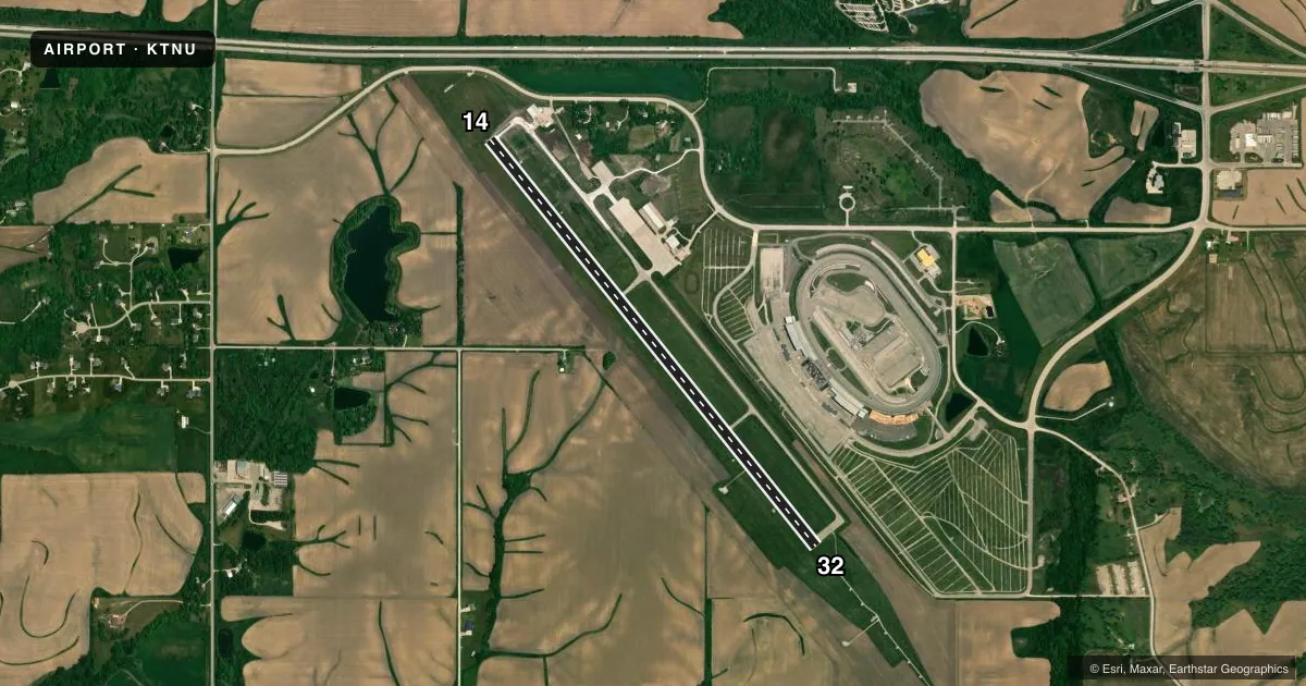
Airport sketch
Runways drawn to scale from FAA survey coordinates, rendered over satellite imagery. Not for navigation.
Approaches & charts
ILS · 1
Services on the field
Fuel grades, oxygen, maintenance, ramp storage and lighting — as declared to the FAA by the airport operator.
Fuel & services
- Fuel
- 100LLA
- Oxygen (bottled)
- Not available
- Oxygen (bulk)
- Not available
- Airframe repair
- Major
- Power plant repair
- Major
- Other services
- CHTR,INSTR,RNTL,SALES
Ramp & ground
- Transient storage
- Tie-down
- Hangar
- Landing fee
- No fee published
- Customs
- Not available
- Lighting schedule
- SEE RMK
- Beacon schedule
- SS-SR
- Beacon
- White / Green (civil land)(WG)
- Wind indicator
- Lighted
- Segmented circle
- No
Fuel & FBOs
Cheapest 100LL and Jet A on the field and nearby. Always confirm with the FBO before taxi.
Airport notes
Surface conditions, obstructions, local procedures, lighting outages and other notes published with each FAA cycle.
General notes
- RY 14 IS CALM WIND RY.
- STADIUM WITHIN 3NM, CHECK FOR EVENTS.
- SEASONAL MIGRATORY WATERFOWL INVOF ARPT.
- FOR CD CTC DES MOINES ATCT ON 126.3 OR CALL 515-974-8016.
Lighting notes
- ACTVT MIRL RY 14/32, VASI RYS 14 & 32, REIL RWY 14 AND MALSR RWY 32 - CTAF.
- ULTRA-LIGHT ACTIVITY DISCOURAGED.
Other notes
- 1AFT HRS ONLY CALL (515) 360-1807.
VFR map & nearby airports
VFR sectional. Tap any ICAO chip to open that airport.
Key facts · KTNU
Answer card- ICAO
- KTNU
- Name
- NEWTON MUNI-EARL JOHNSON FLD
- Location
- NEWTON, IOWA
- Elevation
- 952.5 ft MSL
- Traffic pattern altitude
- 1,952.5 ft MSL (1,000 AGL)
- Control tower
- Non-towered (use CTAF)
- Total runways
- 1
- Longest runway
- 14/32 · 5,600 ft
- Published ILS approaches
- 1
- Published frequencies
- 5
- Magnetic variation
- 0°
- Current flight rules
- VFR
- Current wind
- 000° at 5 kt
- Favored runway now
- RWY 32
Newton Muni-Earl Johnson Fld (KTNU) sits in Newton, Iowa. Field elevation is 952.5 ft MSL. The airport has one runway. Runway 14/32 is 5,600 ft long and asphalt. There is no control tower. Pattern altitude is not published, so use the standard 1,000 ft AGL for light piston traffic unless the current Chart Supplement says otherwise. One ILS approach is published for runway 32. Magnetic variation is 0°, so the runway numbers line up with magnetic headings.
Johnson Aviation is on the field. It carries 100LL and Jet A with Prist. If you need them after hours, call the number in the remarks before you go. The published remarks also note seasonal migratory waterfowl near the airport. Ultralight activity is discouraged. A stadium is within 3 NM, so check for event traffic before you depart or arrive. Runway 14 is the calm wind runway. Runway 14/32 has medium intensity lights. VASI is installed on both ends. Runway 14 has REIL. Runway 32 has a medium intensity approach lighting system with runway alignment indicator lights. Use CTAF for local traffic. For clearance delivery, contact Des Moines ATC on the published frequency or by phone before departure if you need IFR release.