METAR & TAF KMIW
Current METAR
Observed 16:53Z
KMIW 241653Z AUTO 25009KT 10SM SCT022 BKN060 24/19 A3000 RMK AO2 SLP154 T02390189
- Wind
- 250° @ 9 kt
- Visibility
- 10 SM
- Temp / Dew
- 24°C / 19°C
- Altimeter
- 30.00 inHg
- Clouds
- BKN
- Density alt
- 2,189 ft
- Ceiling
- 6,000 ft AGL
- Rules
- VFR
Airport info & contacts
Manager on record, flight service, ARTCC, attendance schedule and pattern altitude — published by the FAA and refreshed every 28 days.
Location
- From city
- 3 NM N
- VFR sectional
- CHICAGO
- ARTCC
- ZMP · MINNEAPOLIS
- NOTAM facility
- MIW (NOTAM-D)
Airport manager
- Name
- STEPHEN VALBRACHT
- Phone
- 641-752-0012
- Address
- 2651 170TH ST, MARSHALLTOWN IA 50158
Flight service · Hours
- FSS FOD
- FORT DODGE1-800-WX-BRIEF
- Attendance
- 0800-1700
Frequencies
Tap any row to copy the frequency to your clipboard.
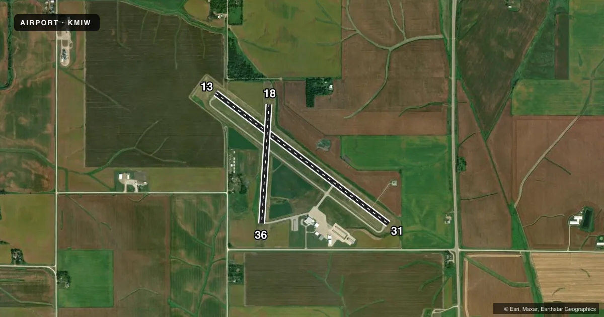
Runways & pattern
Full pagePattern entry · RWY 31
LEFT TRAFFIC| Runway | Heading (°M) | Length | Surface | Traffic |
|---|---|---|---|---|
| 13/31Favored | 126° / 306° | 5,007 ft | ASPH | Standard L |
| 18/36 | 183° / 3° | 2,759 ft | ASPH | Standard L |
Runway end performance
| End | TORA | TODA | ASDA | LDA | VGSI | Approach lights | Obstruction |
|---|---|---|---|---|---|---|---|
| 13 | — | — | — | — | VASI 4-box left(3°) | — | — |
| 31 | — | — | — | — | VASI 4-box left(3°) | — | — |
| 18 | — | — | — | — | — | — | 15', road, 580' from thr, 0' R of cntrln, slope 25 |
| 36 | — | — | — | — | — | — | 19', road, 595' from thr, 0' R of cntrln, slope 20 |
Declared distances in feet. TORA = takeoff run available, TODA = takeoff distance, ASDA = accelerate-stop, LDA = landing distance.
Airport sketch
Runways drawn to scale from FAA survey coordinates, rendered over satellite imagery. Not for navigation.
Approaches & charts
Services on the field
Fuel grades, oxygen, maintenance, ramp storage and lighting — as declared to the FAA by the airport operator.
Fuel & services
- Fuel
- 100LLA
- Oxygen (bottled)
- Low pressure
- Airframe repair
- Major
- Power plant repair
- Major
- Other services
- CHTR,INSTR,RNTL,SALES
Ramp & ground
- Transient storage
- Tie-down
- Hangar
- Landing fee
- No fee published
- Customs
- Not available
- Lighting schedule
- SEE RMK
- Beacon schedule
- SS-SR
- Beacon
- White / Green (civil land)(WG)
- Wind indicator
- Lighted
- Segmented circle
- No
Fuel & FBOs
Cheapest 100LL and Jet A on the field and nearby. Always confirm with the FBO before taxi.
Airport notes
Surface conditions, obstructions, local procedures, lighting outages and other notes published with each FAA cycle.
General notes
- FOR CD CTC DES MOINES APCH ON FREQ 120.9. WHEN DES MOINES APCH CLSD, FOR CD CTC MINNEAPOLIS ARTCC AT 651-463-5588.
Lighting notes
- ACTVT MIRL RY 13/31 & RY 18/36; REIL & VASI RYS 13 & 31 - CTAF.
Approach & departure obstructions
- 13CROPS
Other notes
- 1FOR ARPT ATTENDANT AFTER HRS CALL 641-521-6832.
- MANAGERSTEVE
VFR map & nearby airports
VFR sectional. Tap any ICAO chip to open that airport.
Key facts · KMIW
Answer card- ICAO
- KMIW
- Name
- MARSHALLTOWN MUNI
- Location
- MARSHALLTOWN, IOWA
- Elevation
- 974.6 ft MSL
- Traffic pattern altitude
- 1,974.6 ft MSL (1,000 AGL)
- Control tower
- Non-towered (use CTAF)
- Total runways
- 2
- Longest runway
- 13/31 · 5,007 ft
- Published ILS approaches
- 0
- Published frequencies
- 4
- Magnetic variation
- 1°
- Current flight rules
- VFR
- Current wind
- 250° at 9 kt
- Favored runway now
- RWY 31
Marshalltown Muni (KMIW) sits in Marshalltown, Iowa. Field elevation is 974.6 ft MSL. The airport has two asphalt runways. The longest is runway 13/31 at 5,007 ft. Runway 18/36 is 2,759 ft.
This is a non-towered field. CTAF and UNICOM are both 122.8. For clearance delivery, contact Des Moines Approach on 120.9. When Des Moines Approach is closed, clearance delivery goes through Minneapolis ARTCC. No ILS approaches are published here. Pattern altitude is not published, so light piston traffic should plan for the standard 1,000 ft AGL unless the current FAA Chart Supplement says otherwise.
Marshalltown Aviation is on the field. It carries 100LL and Jet A. Medium intensity runway lights are available on both runways. Runways 13 and 31 also have runway end identifier lights and visual approach slope indicators on CTAF. One operational item to watch is crops near the runway 13 end. That matters on short final and during go-arounds. If you need after-hours help, the published airport attendant number is in the remarks. First-time visitors should brief the non-towered pattern, confirm the runway lighting setup and check the current FAA Chart Supplement for any changes before departure.