METAR & TAF 27P
27P does not publish a METAR.
Showing the nearest reporting station: KIFA (IOWA FALLS MUNI) · 11.0 NM away. Conditions at 27P may differ.
METAR · KIFA
Observed 17:15Z
KIFA 261715Z AUTO 13004KT 10SM CLR 33/23 A2992 RMK AO2 T03340226
- Wind
- 130° @ 4 kt
- Visibility
- 10 SM
- Temp / Dew
- 33°C / 23°C
- Altimeter
- 29.92 inHg
- Clouds
- CLR
- Density alt
- 3,369 ft
- Ceiling
- Unlimited
- Rules
- VFR
Airport info & contacts
Manager on record, flight service, ARTCC, attendance schedule and pattern altitude — published by the FAA and refreshed every 28 days.
Location
- From city
- 2 NM SW
- VFR sectional
- OMAHA
- ARTCC
- ZMP · MINNEAPOLIS
- NOTAM facility
- FOD (NOTAM-D)
Airport manager
- Name
- MARC BROER
- Phone
- 515-729-5119
- Address
- 1505 SANFORD AVENUE, MARSHALLTOWN IA 50158
Flight service · Hours
- FSS FOD
- FORT DODGE1-800-WX-BRIEF
Frequencies
Tap any row to copy the frequency to your clipboard.
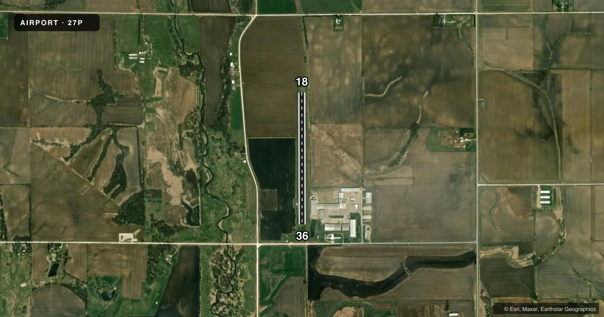
Runways & pattern
Full pagePattern entry · RWY 18
LEFT TRAFFICRunway end performance
| End | TORA | TODA | ASDA | LDA | VGSI | Approach lights | Obstruction |
|---|---|---|---|---|---|---|---|
| 18 | — | — | — | — | — | — | 56', tree, 803' from thr, 110' R of cntrln, slope 14 |
| 36 | — | — | — | — | — | — | 27', pole, 514' from thr, 25' R of cntrln, slope 19 |
Declared distances in feet. TORA = takeoff run available, TODA = takeoff distance, ASDA = accelerate-stop, LDA = landing distance.
Airport sketch
Runways drawn to scale from FAA survey coordinates, rendered over satellite imagery. Not for navigation.
Approaches & charts
Services on the field
Fuel grades, oxygen, maintenance, ramp storage and lighting — as declared to the FAA by the airport operator.
Fuel & services
- Fuel
- Not available
Ramp & ground
- Transient storage
- Not published
- Wind indicator
- Yes
Fuel & FBOs
Cheapest 100LL and Jet A on the field and nearby. Always confirm with the FBO before taxi.
Airport notes
Surface conditions, obstructions, local procedures, lighting outages and other notes published with each FAA cycle.
General notes
- OPEN FOR DALGT OPS ONLY.
- RWY 36 APCH 21:1 TO DSPLCD THR. DSPLCD THR IS NOW 80'.
- FOR CD CTC DES MOINES APCH AT 515-974-8016. WHEN DES MOINES APP CLSD, FOR CD CTC MINNEAPOLIS ARTCC AT 651-463-5588.
- ARPT CLSD FM DEC 1 TO APR 1.
Other notes
- MANAGEROR 515-249-8511
VFR map & nearby airports
VFR sectional. Tap any ICAO chip to open that airport.
Key facts · 27P
Answer card- ICAO
- 27P
- Name
- ELDORA
- Location
- ELDORA, IOWA
- Elevation
- 975 ft MSL
- Traffic pattern altitude
- 1,975 ft MSL (1,000 AGL)
- Control tower
- Non-towered (use CTAF)
- Total runways
- 1
- Longest runway
- 18/36 · 3,035 ft
- Published ILS approaches
- 0
- Published frequencies
- 1
- Magnetic variation
- –
- Current flight rules
- VFR
- Current wind
- 130° at 4 kt
- Favored runway now
- RWY 18
Eldora Airport sits in Eldora, Iowa. Field elevation is 975 ft MSL. It has one runway. The longest is runway 18/36 at 3,035 ft on turf. There is no control tower. CTAF is 122.9. No ILS approaches are published.
Pattern altitude is not published. Use the standard 1,000 ft AGL pattern unless the current Chart Supplement says otherwise. That puts the traffic pattern at 1,975 ft MSL based on the field elevation, but verify the published pattern before you go. The airport is open for daylight operations only. It is also closed from December 1 to April 1.
Runway 36 has a steep approach to the displaced threshold. The displaced threshold is 80 ft. That is worth planning for on arrival. For clearance delivery, contact Des Moines Approach at 515-974-8016. When Des Moines Approach is closed, use Minneapolis ARTCC at 651-463-5588. There are no on-field FBOs listed, so call the airport operator directly before arrival if you need services. The manager phone number is 515-249-8511.