METAR & TAF 0E9
0E9 does not publish a METAR.
Showing the nearest reporting station: KTVK (CENTERVILLE MUNI) · 16.0 NM away. Conditions at 0E9 may differ.
METAR · KTVK
Observed 13:15Z
KTVK 271315Z AUTO 20007KT 10SM CLR 28/25 A2983 RMK A01
- Wind
- 200° @ 7 kt
- Visibility
- 10 SM
- Temp / Dew
- 28°C / 25°C
- Altimeter
- 29.83 inHg
- Clouds
- CLR
- Density alt
- 2,967 ft
- Ceiling
- Unlimited
- Rules
- VFR
Airport info & contacts
Manager on record, flight service, ARTCC, attendance schedule and pattern altitude — published by the FAA and refreshed every 28 days.
Location
- From city
- 4 NM E
- VFR sectional
- OMAHA
- ARTCC
- ZAU · CHICAGO
- NOTAM facility
- FOD (NOTAM-D)
Airport manager
- Name
- JOEL WELLS
- Phone
- 641-344-0250
- Address
- 2644 HIGHWAY 2, CORYDON IA 50060
Flight service · Hours
- FSS FOD
- FORT DODGE1-800-WX-BRIEF
- Attendance
- Unattended
Frequencies
Tap any row to copy the frequency to your clipboard.
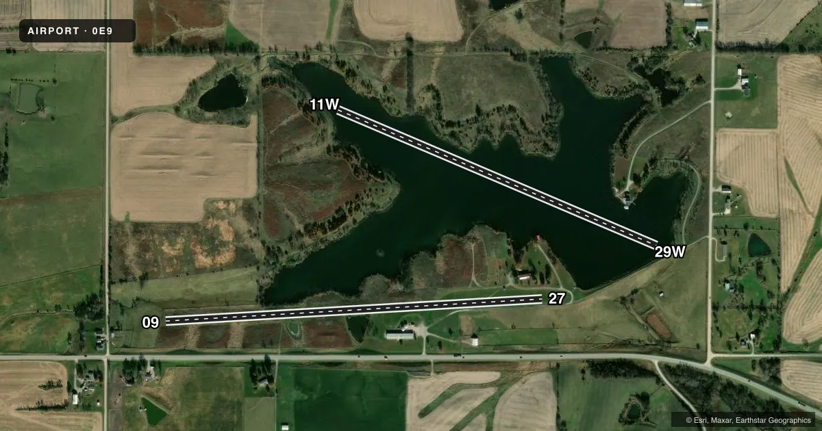
Runways & pattern
Full pagePattern entry · RWY 27
LEFT TRAFFIC| Runway | Heading (°M) | Length | Surface | Traffic |
|---|---|---|---|---|
| 09/27Favored | 83° / 263° | 3,270 ft | TURF | Standard L |
| 11W/29W | 109° / 289° | 3,000 ft | WATER | Standard L |
Runway end performance
| End | TORA | TODA | ASDA | LDA | VGSI | Approach lights | Obstruction |
|---|---|---|---|---|---|---|---|
| 09 | — | — | — | — | — | — | 62', tree, 550' from thr, 80' R of cntrln, slope 8 |
| 27 | — | — | — | — | — | — | 4', road, 120' from thr, 0' R of cntrln, slope 30 |
Declared distances in feet. TORA = takeoff run available, TODA = takeoff distance, ASDA = accelerate-stop, LDA = landing distance.
Airport sketch
Runways drawn to scale from FAA survey coordinates, rendered over satellite imagery. Not for navigation.
Approaches & charts
Services on the field
Fuel grades, oxygen, maintenance, ramp storage and lighting — as declared to the FAA by the airport operator.
Fuel & services
- Fuel
- MOGAS
Ramp & ground
- Transient storage
- Not published
- Landing fee
- No fee published
- Wind indicator
- Yes
- Segmented circle
- No
Fuel & FBOs
Cheapest 100LL and Jet A on the field and nearby. Always confirm with the FBO before taxi.
Airport notes
Surface conditions, obstructions, local procedures, lighting outages and other notes published with each FAA cycle.
General notes
- RY 09 HAS TALL GRASS & WEEDS HIDING DSPLCD THLD MARKER CONES.
Approach & departure obstructions
- 0909/27 ENDS & DSPLCD THLD MARKED WITH YELLOW CONES; TWO OUTBOARD CONES EACH SIDE OF RY MARK DSPLCD THLD.
- 09APCH SLOPE 26:1 TO DSPLCD THLD.
Other notes
- PROVIDED APPROACHES ARE MAINTAINED FOR A 20:1 GLIDE SLOPE AND TRANSITIONAL SURFACES FOR A 7:1 SLOPE.
VFR map & nearby airports
VFR sectional. Tap any ICAO chip to open that airport.
Key facts · 0E9
Answer card- ICAO
- 0E9
- Name
- CORYDON
- Location
- CORYDON, IOWA
- Elevation
- 1,045 ft MSL
- Traffic pattern altitude
- 2,045 ft MSL (1,000 AGL)
- Control tower
- Non-towered (use CTAF)
- Total runways
- 2
- Longest runway
- 09/27 · 3,270 ft
- Published ILS approaches
- 0
- Published frequencies
- 2
- Magnetic variation
- 4°
- Current flight rules
- VFR
- Current wind
- 200° at 7 kt
- Favored runway now
- RWY 27
Corydon Airport sits in Corydon, Iowa. Field elevation is 1,045 ft MSL. The airport has two runways. The longest is 3,270 ft on 09/27. The other runway is 11W/29W at 3,000 ft on water. There is no control tower. CTAF and UNICOM are both 122.8.
No ILS approaches are published here. Pattern altitude is not published. Use the standard 1,000 ft AGL pattern for light piston traffic unless the current Chart Supplement says otherwise. That puts the traffic pattern at about 2,045 ft MSL based on the field elevation, but verify the published pattern before you fly it.
There are no on-field FBOs listed, so plan to confirm services directly with the airport operator or by calling the field on CTAF or UNICOM before arrival. Published remarks matter here. Runway 09 has tall grass and weeds that can hide the displaced threshold cones. The runway ends and displaced thresholds on 09/27 are marked with yellow cones. The approach to the displaced threshold is steep enough to pay attention to on short final. The published approach surfaces are maintained for 20 to 1 glide slope protection, with transitional surfaces at 7 to 1. This is a non-towered field with limited published instrument support, so a current chart check and a careful look at the runway markings are smart before you go in.