METAR & TAF KBNW
Current METAR
Observed 20:15Z
KBNW 272015Z AUTO VRB06G11KT 10SM FEW033 35/28 A2975 RMK AO2
- Wind
- VAR @ 6G11 kt
- Visibility
- 10 SM
- Temp / Dew
- 35°C / 28°C
- Altimeter
- 29.75 inHg
- Clouds
- FEW
- Density alt
- 4,050 ft
- Ceiling
- Unlimited
- Rules
- VFR
Airport info & contacts
Manager on record, flight service, ARTCC, attendance schedule and pattern altitude — published by the FAA and refreshed every 28 days.
Location
- From city
- 2 NM SE
- VFR sectional
- OMAHA
- ARTCC
- ZMP · MINNEAPOLIS
- NOTAM facility
- BNW (NOTAM-D)
Airport manager
- Name
- DALE FARNHAM
- Phone
- 515-432-1018
- Address
- 424 CPL ROGER SNEDDEN DR, BOONE IA 50036-7520
Flight service · Hours
- FSS FOD
- FORT DODGE1-800-WX-BRIEF
- Attendance
- 0800-1700
Frequencies
Tap any row to copy the frequency to your clipboard.
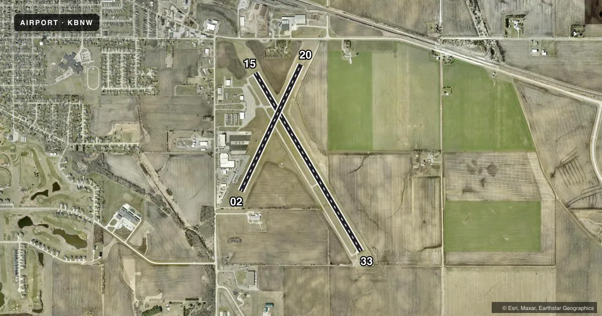
Runways & pattern
Full pagePattern entry · RWY 02
RIGHT TRAFFIC| Runway | Heading (°M) | Length | Surface | Traffic |
|---|---|---|---|---|
| 15/33 | 146° / 326° | 4,808 ft | CONC | 33 R |
| 02/20Favored | 22° / 202° | 3,248 ft | TURF | 02 R |
Runway end performance
| End | TORA | TODA | ASDA | LDA | VGSI | Approach lights | Obstruction |
|---|---|---|---|---|---|---|---|
| 15 | 4,807' | 4,807' | 4,807' | 4,667' | PAPI 2-box left(3°) | — | 41', tree, 1026' from thr, 164' R of cntrln, slope 20 |
| 33 | 4,667' | 4,807' | 4,807' | 4,807' | PAPI 2-box left(3°) | — | — |
| 20 | — | — | — | — | — | — | 50', tree, 1430' from thr, 0' R of cntrln, slope 28 |
Declared distances in feet. TORA = takeoff run available, TODA = takeoff distance, ASDA = accelerate-stop, LDA = landing distance.
Airport sketch
Runways drawn to scale from FAA survey coordinates, rendered over satellite imagery. Not for navigation.
Approaches & charts
Services on the field
Fuel grades, oxygen, maintenance, ramp storage and lighting — as declared to the FAA by the airport operator.
Fuel & services
- Fuel
- 100LLAMOGAS
- Airframe repair
- Minor
- Power plant repair
- Minor
- Other services
- INSTR,RNTL
Ramp & ground
- Transient storage
- Tie-down
- Hangar
- Landing fee
- No fee published
- Customs
- Not available
- Lighting schedule
- SEE RMK
- Beacon schedule
- SS-SR
- Beacon
- White / Green (civil land)(WG)
- Wind indicator
- Lighted
- Segmented circle
- No
Fuel & FBOs
Cheapest 100LL and Jet A on the field and nearby. Always confirm with the FBO before taxi.
Airport notes
Surface conditions, obstructions, local procedures, lighting outages and other notes published with each FAA cycle.
General notes
- ANG OPS AV946-2388 - 515-432-6351 OR 36.7/142.6/143.25/231.55.
- UNATNDD HOL & WHEN CEILING LESS THAN 400 FT OR VIS LESS THAN 1 MI.
- FOR CD CTC DES MOINES ATCT AT 515-974- 8016.
- FUEL AFT HR OR HOL - 515-291-5094.
- RWY 02/20 NO SNOW REMOVAL, RWY CLSD WHEN SNOW CONDITIONS EXIST.
Lighting notes
- ACTVT REIL RWY 15; PAPI RWY 15 & 33; MIRL RWY 15/33 - CTAF.
Approach & departure obstructions
- 02YELLOW CONES.
- 20YELLOW CONES.
- 1528:1 TO DTHR.
Other notes
- 3AFT HR - 515-291-5094 OR 515-460-3892.
- OWNERJOE PUNDZAK
VFR map & nearby airports
VFR sectional. Tap any ICAO chip to open that airport.
Key facts · KBNW
Answer card- ICAO
- KBNW
- Name
- BOONE MUNI
- Location
- BOONE, IOWA
- Elevation
- 1,160.3 ft MSL
- Traffic pattern altitude
- 2,160.3 ft MSL (1,000 AGL)
- Control tower
- Non-towered (use CTAF)
- Total runways
- 2
- Longest runway
- 15/33 · 4,808 ft
- Published ILS approaches
- 0
- Published frequencies
- 4
- Magnetic variation
- 3°
- Current flight rules
- VFR
- Current wind
- 000° at 6 kt
- Favored runway now
- RWY 02
Boone Muni sits in Boone, Iowa. Field elevation is 1,160.3 ft MSL. The airport has two runways. The longest is 15/33 at 4,808 ft of concrete. The other runway is 02/20 at 3,248 ft of turf. There is no control tower. No ILS approaches are published here.
Pattern altitude is not published. For a light piston, plan on the standard 1,000 ft AGL pattern unless the current Chart Supplement says otherwise. Runway 15 has a displaced-threshold obstacle note. Runway 02 is marked with yellow cones. Runway 20 is marked with yellow cones. Runway 02/20 has no snow removal. It is closed when snow conditions exist.
Farnham Aviation is on the field. It carries 100LL, Jet A and MOGAS. After hours fuel is available by calling the numbers in the Chart Supplement. Lighting is pilot controlled on CTAF. Runways 15 and 33 have PAPI. Runway 15 also has REIL. The airport is unattended on holidays and when the ceiling is below 400 ft or visibility is less than 1 mile. Des Moines provides approach and departure service on the published frequencies. Check the current Chart Supplement for any local procedures before you go.