METAR & TAF 2Y4
2Y4 does not publish a METAR.
Showing the nearest reporting station: KFOD (FORT DODGE RGNL) · 21.3 NM away. Conditions at 2Y4 may differ.
METAR · KFOD
Observed 20:56Z
KFOD 272056Z AUTO 31006KT 10SM CLR 33/20 A2979 RMK AO2 SLP087 T03330200 51004 $
- Wind
- 310° @ 6 kt
- Visibility
- 10 SM
- Temp / Dew
- 33°C / 20°C
- Altimeter
- 29.79 inHg
- Clouds
- CLR
- Density alt
- 3,829 ft
- Ceiling
- Unlimited
- Rules
- VFR
Airport info & contacts
Manager on record, flight service, ARTCC, attendance schedule and pattern altitude — published by the FAA and refreshed every 28 days.
Location
- From city
- 1 NM SE
- VFR sectional
- OMAHA
- ARTCC
- ZMP · MINNEAPOLIS
- NOTAM facility
- FOD (NOTAM-D)
Airport manager
- Name
- PHILIP HAMMEN
- Phone
- 712-297-7041
- Address
- 335 MAIN, ROCKWELL CITY IA 50579
Flight service · Hours
- FSS FOD
- FORT DODGE1-800-WX-BRIEF
- Attendance
- Unattended
Frequencies
Tap any row to copy the frequency to your clipboard.
Runways & pattern
Full pagePattern entry · RWY 30
LEFT TRAFFICRunway end performance
| End | TORA | TODA | ASDA | LDA | VGSI | Approach lights | Obstruction |
|---|---|---|---|---|---|---|---|
| 12 | 3,500' | 3,500' | 3,500' | 2,300' | — | — | 16', pole, 372' from thr, 82' R of cntrln, slope 10 |
| 30 | 3,500' | 3,500' | 3,500' | 3,500' | — | — | 12', road, 395' from thr, 125' R of cntrln, slope 16 |
Declared distances in feet. TORA = takeoff run available, TODA = takeoff distance, ASDA = accelerate-stop, LDA = landing distance.
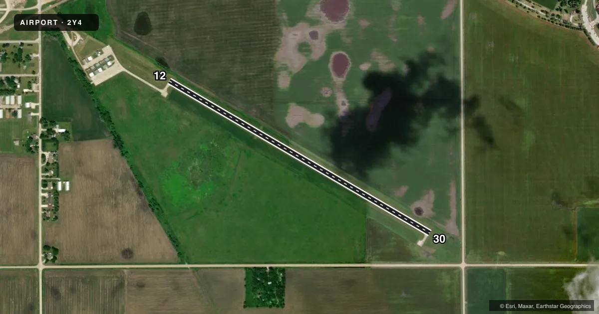
Airport sketch
Runways drawn to scale from FAA survey coordinates, rendered over satellite imagery. Not for navigation.
Approaches & charts
Services on the field
Fuel grades, oxygen, maintenance, ramp storage and lighting — as declared to the FAA by the airport operator.
Fuel & services
- Fuel
- 100LL
- Oxygen (bottled)
- Not available
- Oxygen (bulk)
- Not available
- Airframe repair
- Not available
- Power plant repair
- Not available
Ramp & ground
- Transient storage
- Tie-down
- Landing fee
- No fee published
- Lighting schedule
- SEE RMK
- Wind indicator
- Lighted
- Segmented circle
- No
Fuel & FBOs
Cheapest 100LL and Jet A on the field and nearby. Always confirm with the FBO before taxi.
Airport notes
Surface conditions, obstructions, local procedures, lighting outages and other notes published with each FAA cycle.
General notes
- RADIO CTLD ACFT INVOF ARPT.
- FOR CD CTC MINNEAPOLIS ARTCC AT 651-463-5588.
Lighting notes
- DUSK-DAWN. FOR MIRL RY 12/30 KEY 122.8 3 TIMES HIGH INTST ONLY.
Fuel notes
- 100LLFOR FUEL CALL POLICE AT (712) 297-7583.
Approach & departure obstructions
- 12APCH RATIO 50:1 FM DSPLCD THR.
VFR map & nearby airports
VFR sectional. Tap any ICAO chip to open that airport.
Key facts · 2Y4
Answer card- ICAO
- 2Y4
- Name
- ROCKWELL CITY MUNI
- Location
- ROCKWELL CITY, IOWA
- Elevation
- 1,215.9 ft MSL
- Traffic pattern altitude
- 2,215.9 ft MSL (1,000 AGL)
- Control tower
- Non-towered (use CTAF)
- Total runways
- 1
- Longest runway
- 12/30 · 3,503 ft
- Published ILS approaches
- 0
- Published frequencies
- 2
- Magnetic variation
- 5°
- Current flight rules
- VFR
- Current wind
- 310° at 6 kt
- Favored runway now
- RWY 30
Rockwell City Muni sits in Rockwell City, Iowa. Field elevation is 1,215.9 ft MSL. The airport has one runway. Runway 12/30 is 3,503 ft long with concrete pavement. There is no control tower. CTAF and UNICOM are both 122.8. No ILS approaches are published here.
Pattern altitude is not published. Use the standard 1,000 ft AGL pattern for light piston traffic unless the current Chart Supplement or local traffic calls for something different. The field is not busy in the way a metro airport is, but the published remarks say aircraft in the vicinity are radio controlled. Make your calls early and stay alert for other traffic.
The on-field FBO is Rockwell City Municipal Airport. It carries 100LL. For fuel, the published remarks direct pilots to call police at (712) 297-7583. Lighting is available from dusk to dawn. For medium intensity runway lights on runway 12/30, key 122.8 three times for high intensity only. There is also a published note on runway 12 about the approach ratio from the displaced threshold. Check the current Chart Supplement before you go if you need the exact details. Clearance delivery is handled through Minneapolis ARTCC at 651-463-5588.