METAR & TAF KDNS
Current METAR
Observed 18:15Z
KDNS 271815Z AUTO 08008G13KT 050V110 CLR 34/28 A2980 RMK AO2
- Wind
- 080° @ 8G13 kt
- Visibility
- —
- Temp / Dew
- 34°C / 28°C
- Altimeter
- 29.80 inHg
- Clouds
- CLR
- Density alt
- 4,009 ft
- Ceiling
- Unlimited
- Rules
- VFR
Airport info & contacts
Manager on record, flight service, ARTCC, attendance schedule and pattern altitude — published by the FAA and refreshed every 28 days.
Location
- From city
- 2 NM SW
- VFR sectional
- OMAHA
- ARTCC
- ZMP · MINNEAPOLIS
- NOTAM facility
- DNS (NOTAM-D)
Airport manager
- Name
- RYAN LEED
- Phone
- 712-263-6424
- Address
- 2582 AIRPORT ST, DENISON IA 51442
Flight service · Hours
- FSS FOD
- FORT DODGE1-800-WX-BRIEF
- Attendance
- MON - FRI · 0800-1700
Frequencies
Tap any row to copy the frequency to your clipboard.
Runways & pattern
Full pagePattern entry · RWY 12
LEFT TRAFFIC| Runway | Heading (°M) | Length | Surface | Traffic |
|---|---|---|---|---|
| 12/30Favored | 120° / 300° | 5,000 ft | CONC | Standard L |
| 18/36 | 175° / 355° | 3,200 ft | TURF | Standard L |
Runway end performance
| End | TORA | TODA | ASDA | LDA | VGSI | Approach lights | Obstruction |
|---|---|---|---|---|---|---|---|
| 12 | — | — | — | — | PAPI 2-box left(3°) | — | — |
| 30 | — | — | — | — | PAPI 2-box left(3.5°) | — | 10', gnd, 399' from thr, 244' R of cntrln, slope 20 |
Declared distances in feet. TORA = takeoff run available, TODA = takeoff distance, ASDA = accelerate-stop, LDA = landing distance.
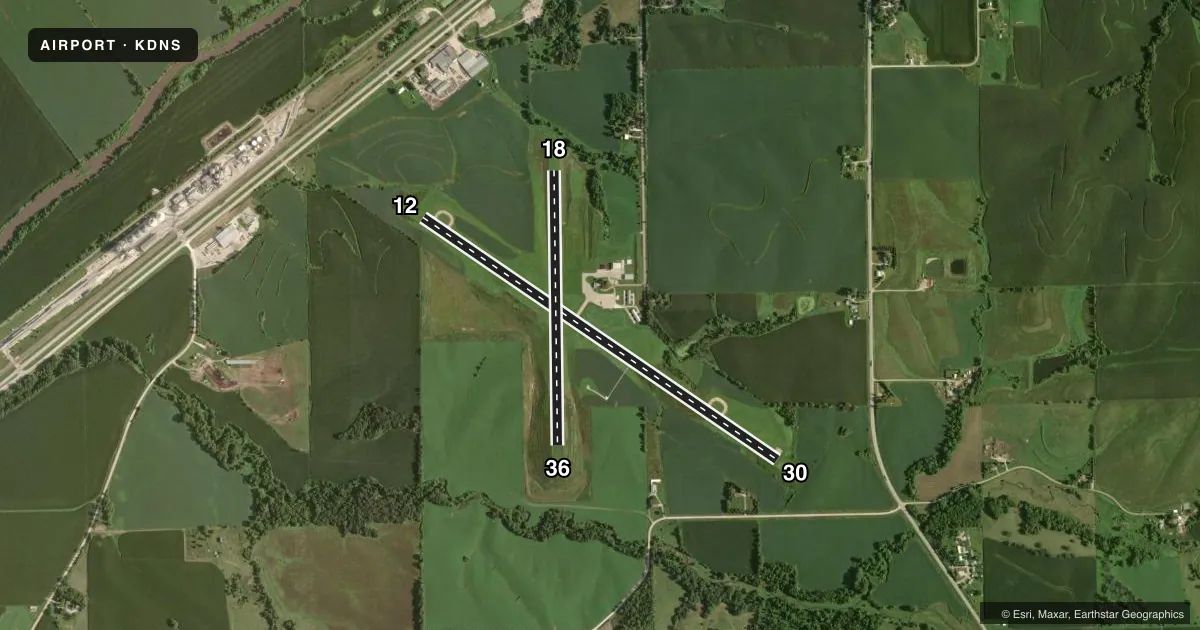
Airport sketch
Runways drawn to scale from FAA survey coordinates, rendered over satellite imagery. Not for navigation.
Approaches & charts
Services on the field
Fuel grades, oxygen, maintenance, ramp storage and lighting — as declared to the FAA by the airport operator.
Fuel & services
- Fuel
- 100LLA
- Oxygen (bottled)
- Not available
- Oxygen (bulk)
- Not available
- Airframe repair
- Not available
- Power plant repair
- Not available
Ramp & ground
- Transient storage
- Tie-down
- Hangar
- Landing fee
- No fee published
- Customs
- Not available
- Lighting schedule
- SEE RMK
- Beacon schedule
- SS-SR
- Beacon
- White / Green (civil land)(WG)
- Wind indicator
- Lighted
- Segmented circle
- No
Fuel & FBOs
Cheapest 100LL and Jet A on the field and nearby. Always confirm with the FBO before taxi.
Airport notes
Surface conditions, obstructions, local procedures, lighting outages and other notes published with each FAA cycle.
General notes
- RWY 30 IS CALM WIND RWY.
- CAUTION FOR WILDLIFE IN VICINITY.
- FOR CD IF UNA TO CTC ON FSS FREQ, CTC MINNEAPOLIS ARTCC AT 651-463-5588.
Lighting notes
- MIRL RWY 12/30 PRESET ON LOW INTST; TO INCR INTST AND ACTVT PAPI RWYS 12 AND 30 AND REIL RWYS 12 AND 30 - CTAF.
Fuel notes
- 100LLFOR FUEL CALL AMGR 712-263-6424 OR (CELL) 712-210-1900.
Runway surface & condition
- 18/36CLSD NOV-APR.
Approach & departure obstructions
- 306 FT BRUSH 55 FT FROM RWY END 125 FT RIGHT ON APPROACH 1:1 APPROACH SLOPE.
- 1818/36 THRS & SIDES MARKED WITH YELLOW CONES.
Other notes
- 1AFTER 1700 CALL 712-210-1900
- 18/36ROUGH SURFACE
VFR map & nearby airports
VFR sectional. Tap any ICAO chip to open that airport.
Key facts · KDNS
Answer card- ICAO
- KDNS
- Name
- DENISON MUNI
- Location
- DENISON, IOWA
- Elevation
- 1,274.3 ft MSL
- Traffic pattern altitude
- 2,274.3 ft MSL (1,000 AGL)
- Control tower
- Non-towered (use CTAF)
- Total runways
- 2
- Longest runway
- 12/30 · 5,000 ft
- Published ILS approaches
- 0
- Published frequencies
- 2
- Magnetic variation
- 4°
- Current flight rules
- VFR
- Current wind
- 080° at 8 kt
- Favored runway now
- RWY 12
Denison Muni is in Denison, Iowa. The field elevation is 1,274.3 ft MSL. It has two runways. The longest is runway 12/30 at 5,000 ft of concrete. Runway 18/36 is 3,200 ft of turf. There is no control tower. CTAF and UNICOM are both 122.8.
No ILS approaches are published here. Pattern altitude is not published, so use standard light piston pattern planning unless the current FAA Chart Supplement says otherwise. The field sits in the low plains of western Iowa, so wind and surface conditions matter more than terrain. Runway 30 is the calm wind runway. Runway 18/36 is closed from November through April. The 18/36 thresholds and sides are marked with yellow cones. That runway also has a rough surface.
Denison Municipal Airport is on the field. It carries 100LL and Jet A. For fuel or after 1700, call the airport manager or the posted cell number before you go. Lighting on 12/30 is preset to low intensity. Use the CTAF to raise intensity and activate the PAPI and runway end identifier lights for 12 and 30. Watch for wildlife in the area. There is also a brush obstruction near the approach end of runway 30, so plan your landing and departure with that in mind.