METAR & TAF 1Y9
1Y9 does not publish a METAR.
Showing the nearest reporting station: KSHL (SHELDON RGNL) · 15.2 NM away. Conditions at 1Y9 may differ.
METAR · KSHL
Observed 11:15Z
KSHL 271115Z AUTO RMK AO2 PNO PWINO
- Wind
- Calm
- Visibility
- —
- Temp / Dew
- —
- Altimeter
- —
- Clouds
- Clear
- Density alt
- —
- Ceiling
- Unlimited
- Rules
- VFR
Airport info & contacts
Manager on record, flight service, ARTCC, attendance schedule and pattern altitude — published by the FAA and refreshed every 28 days.
Location
- From city
- 1 NM E
- VFR sectional
- OMAHA
- ARTCC
- ZMP · MINNEAPOLIS
- NOTAM facility
- FOD (NOTAM-D)
Airport manager
- Name
- BRIAN FISCH
- Phone
- 712-448-2522
- Address
- 4217 ROOSEVELT AVE, PAULLINA IA 51046
Flight service · Hours
- FSS FOD
- FORT DODGE1-800-WX-BRIEF
- Attendance
- Unattended
Frequencies
Tap any row to copy the frequency to your clipboard.
Runways & pattern
Full pagePattern entry · RWY 17
LEFT TRAFFICRunway end performance
| End | TORA | TODA | ASDA | LDA | VGSI | Approach lights | Obstruction |
|---|---|---|---|---|---|---|---|
| 17 | — | — | — | — | — | — | 30', tree, 5' from thr, 125' R of cntrln, slope 0 |
| 35 | — | — | — | — | — | — | 12', road, 350' from thr, 0' R of cntrln, slope 29 |
Declared distances in feet. TORA = takeoff run available, TODA = takeoff distance, ASDA = accelerate-stop, LDA = landing distance.
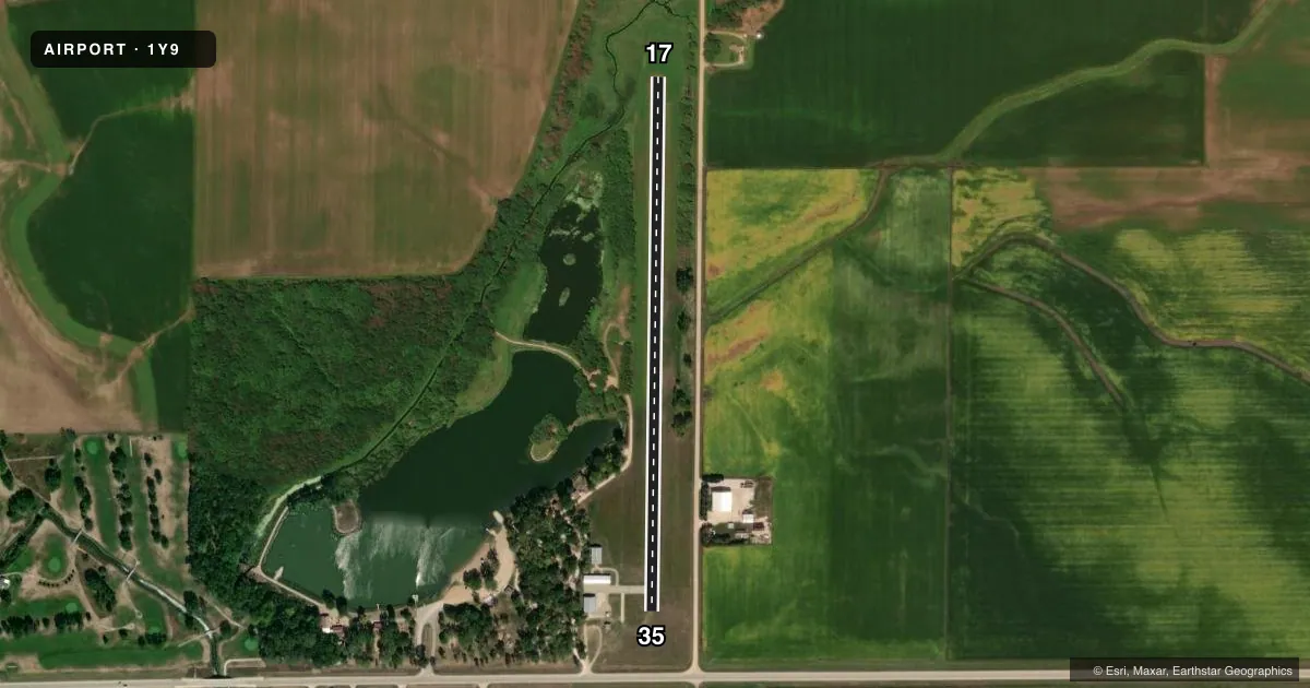
Airport sketch
Runways drawn to scale from FAA survey coordinates, rendered over satellite imagery. Not for navigation.
Approaches & charts
Services on the field
Fuel grades, oxygen, maintenance, ramp storage and lighting — as declared to the FAA by the airport operator.
Fuel & services
- Fuel
- 100LL
- Oxygen (bottled)
- Not available
- Oxygen (bulk)
- Not available
- Airframe repair
- Not available
- Power plant repair
- Not available
Ramp & ground
- Transient storage
- Tie-down
- Hangar
- Landing fee
- No fee published
- Lighting schedule
- SEE RMK
- Wind indicator
- Lighted
- Segmented circle
- No
Fuel & FBOs
Cheapest 100LL and Jet A on the field and nearby. Always confirm with the FBO before taxi.
Airport notes
Surface conditions, obstructions, local procedures, lighting outages and other notes published with each FAA cycle.
General notes
- NUMEROUS WINDMILLS 2 NM NORTH AND EAST OF AIRPORT
- FOR CD CTC MINNEAPOLIS ARTCC AT 651-463-5588.
Lighting notes
- ACTVT LIRL RY 17/35 - CTAF.
Fuel notes
- 100LLFOR FUEL CALL (712) 448-2522.
Runway surface & condition
- 17/35NSTD LIRL; RY LGTS 60 FT FM CNTRLN.
- 17/3528 FT ASPH IN CENTER OF 120 FT WIDE TURF STRIP.
Approach & departure obstructions
- 17CONTROLLING OBSTN EXCEEDS A 45 DEG SLP.
VFR map & nearby airports
VFR sectional. Tap any ICAO chip to open that airport.
Key facts · 1Y9
Answer card- ICAO
- 1Y9
- Name
- PAULLINA MUNI
- Location
- PAULLINA, IOWA
- Elevation
- 1,385 ft MSL
- Traffic pattern altitude
- 2,385 ft MSL (1,000 AGL)
- Control tower
- Non-towered (use CTAF)
- Total runways
- 1
- Longest runway
- 17/35 · 2,800 ft
- Published ILS approaches
- 0
- Published frequencies
- 1
- Magnetic variation
- 6°
- Current flight rules
- VFR
- Current wind
- Calm / unavailable
- Favored runway now
- –
Paullina Muni sits in Paullina, Iowa. Field elevation is 1,385 ft MSL. The airport has one runway. Runway 17/35 is 2,800 ft long with asphalt-turf construction. The magnetic headings are 181° and 1°. This is an uncontrolled field with no tower. CTAF is 122.9.
No ILS approaches are published here. Pattern altitude is not published, so use the standard 1,000 ft AGL for light piston traffic unless the current Chart Supplement says otherwise. The on-field airport contact is Paullina Municipal Airport. Call (712) 448-2522 for fuel and current field details. Published remarks note low intensity runway lights on 17/35. They are activated on CTAF. The lights are installed 60 feet from the centerline. There is also a 28 foot wide asphalt strip in the center of a 120 foot wide turf strip.
A first-time pilot should pay attention to the obstruction note on runway 17. The controlling obstruction exceeds a 45 degree slope. There are also numerous windmills about 2 NM north and east of the airport. For clearance delivery, contact Minneapolis ARTCC at 651-463-5588. Check the current FAA Chart Supplement before you go. That is the place to confirm lighting use. It is also the place to confirm pattern details. Check any current operational notes.