METAR & TAF KLRJ
Current METAR
Observed 20:15Z
KLRJ 272015Z AUTO 33005KT 10SM CLR A2980 RMK AO2
- Wind
- 330° @ 5 kt
- Visibility
- 10 SM
- Temp / Dew
- —
- Altimeter
- 29.80 inHg
- Clouds
- CLR
- Density alt
- —
- Ceiling
- Unlimited
- Rules
- VFR
Airport info & contacts
Manager on record, flight service, ARTCC, attendance schedule and pattern altitude — published by the FAA and refreshed every 28 days.
Location
- From city
- 2 NM SW
- VFR sectional
- OMAHA
- ARTCC
- ZMP · MINNEAPOLIS
- NOTAM facility
- LRJ (NOTAM-D)
Airport manager
- Name
- TOM MULLALLY
- Phone
- (712) 540-1665
- Address
- 1621 AIRPORT DRIVE, LE MARS IA 51031
Flight service · Hours
- FSS FOD
- FORT DODGE1-800-WX-BRIEF
- Attendance
- MON-FRI · 0800-1730
- SAT- SUN · PRIOR REQUEST
Frequencies
Tap any row to copy the frequency to your clipboard.
Runways & pattern
Full pagePattern entry · RWY 36
LEFT TRAFFICRunway end performance
| End | TORA | TODA | ASDA | LDA | VGSI | Approach lights | Obstruction |
|---|---|---|---|---|---|---|---|
| 18 | — | — | — | — | PAPI 2-box left(3°) | — | 16', tree, 282' from thr, 54' R of cntrln, slope 5 |
| 36 | — | — | — | — | PAPI 2-box right(3°) | — | 15', road, 500' from thr, 250' R of cntrln, slope 20 |
Declared distances in feet. TORA = takeoff run available, TODA = takeoff distance, ASDA = accelerate-stop, LDA = landing distance.
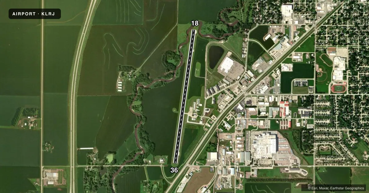
Airport sketch
Runways drawn to scale from FAA survey coordinates, rendered over satellite imagery. Not for navigation.
Approaches & charts
Services on the field
Fuel grades, oxygen, maintenance, ramp storage and lighting — as declared to the FAA by the airport operator.
Fuel & services
- Fuel
- 100LLA+
- Oxygen (bottled)
- Not available
- Oxygen (bulk)
- Not available
- Airframe repair
- Minor
- Power plant repair
- Minor
- Other services
- SALES
Ramp & ground
- Transient storage
- Tie-down
- Hangar
- Landing fee
- No fee published
- Customs
- Not available
- Lighting schedule
- SEE RMK
- Beacon schedule
- SS-SR
- Beacon
- White / Green (civil land)(WG)
- Wind indicator
- Lighted
- Segmented circle
- Yes
Fuel & FBOs
Cheapest 100LL and Jet A on the field and nearby. Always confirm with the FBO before taxi.
Airport notes
Surface conditions, obstructions, local procedures, lighting outages and other notes published with each FAA cycle.
General notes
- AFT HRS SVC FEE.
- RY 36 IS CALM WIND RY.
- FOR CD CTC SIOUX CITY ATCT ON 124.6 OR CALL 712-293-2482.
- COLD TEMPERATURE AIRPORT. ALTITUDE CORRECTION REQUIRED AT OR BELOW -23C.
Lighting notes
- ACTVT REIL RWYS 18 & 36; PAPI RWY 18 & 36; MIRL RWY 18/36 - CTAF.
Approach & departure obstructions
- 188 FT SHRUBS 25 FT FROM RWY END 85 FT RIGHT ON APCH.
- 1836:1 CLEARANCE TO DTHR.
- 18OBSTN SLOPE 50:1 TO DTHR.
- 36APCH SLOPE 33:1 TO DTHR.
Other notes
- PRVDD APCH TO EACH RWY IS MAINTD FOR A MIN 20:1 GLIDE SLOPE AND THE TRSNL SFC BE MAINTD FOR A 7:1 SLOPE.
- MANAGEREMAIL ADDRESS: ULTRAFLIGHTLLC51031@GMAIL.COM (ALL LOWER CASE)
- MANAGERAFTER HRS NMBR IS 712-540-1665
VFR map & nearby airports
VFR sectional. Tap any ICAO chip to open that airport.
Key facts · KLRJ
Answer card- ICAO
- KLRJ
- Name
- LE MARS MUNI
- Location
- LE MARS, IOWA
- Elevation
- 1,197 ft MSL
- Traffic pattern altitude
- 2,197 ft MSL (1,000 AGL)
- Control tower
- Non-towered (use CTAF)
- Total runways
- 1
- Longest runway
- 18/36 · 5,056 ft
- Published ILS approaches
- 0
- Published frequencies
- 4
- Magnetic variation
- 3°
- Current flight rules
- VFR
- Current wind
- 330° at 5 kt
- Favored runway now
- RWY 36
Le Mars Muni is in Le Mars, Iowa. The field elevation is 1,197 ft MSL. It has one runway. Runway 18/36 is 5,056 ft long with a concrete surface. The airport is non-towered. CTAF and UNICOM are both 122.8. Sioux City Approach and Departure are on 124.6 and 307.0 for IFR services and clearance delivery. No ILS approaches are published here.
Pattern altitude is not published. Use 1,000 ft AGL for light piston traffic unless the current Chart Supplement says otherwise. That puts the standard pattern around 2,197 ft MSL. Runway 36 is the calm wind runway. The runway has REILs, PAPI and medium intensity runway lights. That helps for night work and marginal visibility.
Ultra Flight is on the field. It carries 100LL and Jet A. After-hours service fee applies. The airport also has published cold temperature correction guidance. Altitude correction is required at or below minus 23 degrees Celsius. Watch the runway end areas on 18. There are shrubs near the departure end and on the right side of the approach path. Runway 36 also has a displaced threshold with a published approach slope note. A first-time pilot should brief the displaced thresholds. Brief the obstacle notes. Brief the non-towered traffic flow before arrival.