METAR & TAF 7G9
7G9 does not publish a METAR.
Showing the nearest reporting station: KFSD (JOE FOSS FLD) · 18.0 NM away. Conditions at 7G9 may differ.
METAR · KFSD
Observed 13:56Z
KFSD 241356Z 18014KT 10SM BKN010 OVC017 20/18 A3002 RMK AO2 SLP159 T02000178
- Wind
- 180° @ 14 kt
- Visibility
- 10 SM
- Temp / Dew
- 20°C / 18°C
- Altimeter
- 30.02 inHg
- Clouds
- OVC
- Density alt
- 2,076 ft
- Ceiling
- 1,000 ft AGL
- Rules
- MVFR
Airport info & contacts
Manager on record, flight service, ARTCC, attendance schedule and pattern altitude — published by the FAA and refreshed every 28 days.
Location
- From city
- 1 NM NE
- VFR sectional
- OMAHA
- ARTCC
- ZMP · MINNEAPOLIS
- NOTAM facility
- HON (NOTAM-D)
Airport manager
- Name
- MARSHALL CHRISTENSEN
- Phone
- 605-359-4219
- Address
- 1000 RIVERVIEW RD., CANTON SD 57013
Flight service · Hours
- FSS HON
- HURON1-800-WX-BRIEF
- Attendance
- MON-FRI · 0900-1700
Frequencies
Tap any row to copy the frequency to your clipboard.
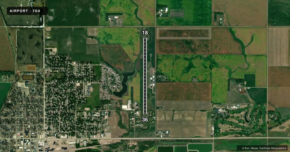
Runways & pattern
Full pagePattern entry · RWY 18
LEFT TRAFFICRunway end performance
| End | TORA | TODA | ASDA | LDA | VGSI | Approach lights | Obstruction |
|---|---|---|---|---|---|---|---|
| 18 | — | — | — | — | PAPI 2-box left(3°) | — | 132', road, 550' from thr, 0' R of cntrln, slope 26 |
| 36 | — | — | — | — | PAPI 2-box left(3°) | — | 34', trees, 770' from thr, 41' R of cntrln, slope 16 |
Declared distances in feet. TORA = takeoff run available, TODA = takeoff distance, ASDA = accelerate-stop, LDA = landing distance.
Airport sketch
Runways drawn to scale from FAA survey coordinates, rendered over satellite imagery. Not for navigation.
Approaches & charts
Services on the field
Fuel grades, oxygen, maintenance, ramp storage and lighting — as declared to the FAA by the airport operator.
Fuel & services
- Fuel
- 100LL
- Oxygen (bottled)
- Not available
- Oxygen (bulk)
- Not available
- Airframe repair
- Minor
- Power plant repair
- Not available
- Other services
- AGRI
Ramp & ground
- Transient storage
- Tie-down
- Hangar
- Landing fee
- No fee published
- Customs
- Not available
- Beacon schedule
- SS-SR
- Beacon
- White / Green (civil land)(WG)
- Wind indicator
- Lighted
- Segmented circle
- Yes
Fuel & FBOs
Cheapest 100LL and Jet A on the field and nearby. Always confirm with the FBO before taxi.
Airport notes
Surface conditions, obstructions, local procedures, lighting outages and other notes published with each FAA cycle.
General notes
- DEER & WATERFOWL ON & INVOF OF ARPT.
- FOR CD CTC SIOUX FALLS APCH AT 605-336-8602; WHEN APCH CLSD CTC MINNEAPOLIS ARTCC AT 651-463-5588.
VFR map & nearby airports
VFR sectional. Tap any ICAO chip to open that airport.
Key facts · 7G9
Answer card- ICAO
- 7G9
- Name
- CANTON MUNI
- Location
- CANTON, SOUTH DAKOTA
- Elevation
- 1,290 ft MSL
- Traffic pattern altitude
- 2,290 ft MSL (1,000 AGL)
- Control tower
- Non-towered (use CTAF)
- Total runways
- 1
- Longest runway
- 18/36 · 3,600 ft
- Published ILS approaches
- 0
- Published frequencies
- 2
- Magnetic variation
- 6°
- Current flight rules
- MVFR
- Current wind
- 180° at 14 kt
- Favored runway now
- RWY 18
Canton Muni sits in Canton, South Dakota. The field elevation is 1,290 ft MSL. It has one runway, 18/36, which is 3,600 ft long and asphalt. There is no control tower. CTAF and UNICOM are both 123.0. No ILS approaches are published here.
Pattern altitude is not published. Use the standard 1,000 ft AGL pattern unless the current Chart Supplement says otherwise. For this field, that works out to about 2,290 ft MSL. The on-field FBO is Canton Municipal Airport. It carries AVGAS 100LL. Call (605) 987-9010 before you go if you need current service details.
A couple of operational notes matter here. Deer and waterfowl are reported on and near the airport. Keep a sharp scan on departure, arrival and in the pattern. For clearance delivery, contact Sioux Falls Approach at 605-336-8602. When approach is closed, contact Minneapolis ARTCC at 651-463-5588. If you are planning a first stop here, expect a simple non-towered airport with one short-to-medium asphalt runway and no published ILS backup. Check current weather, runway condition and any local procedures before you launch.