METAR & TAF KLYV
Current METAR
Observed 12:55Z
KLYV 271255Z AUTO 00000KT 5SM BR SCT001 25/25 A2981 RMK AO2
- Wind
- 000° @ 0 kt
- Visibility
- 5 SM
- Temp / Dew
- 25°C / 25°C
- Altimeter
- 29.81 inHg
- Clouds
- SCT
- Density alt
- 3,116 ft
- Ceiling
- Unlimited
- Rules
- MVFR
Airport info & contacts
Manager on record, flight service, ARTCC, attendance schedule and pattern altitude — published by the FAA and refreshed every 28 days.
Location
- From city
- 2 NM S
- VFR sectional
- OMAHA
- ARTCC
- ZMP · MINNEAPOLIS
- NOTAM facility
- LYV (NOTAM-D)
Airport manager
- Name
- BEN BAUM
- Phone
- 507-283-5041
- Address
- 941 US HIGHWAY 75, PO BOX 659, LUVERNE MN 56156-4197
Flight service · Hours
- FSS PNM
- PRINCETON1-800-WX-BRIEF
- Attendance
- MON-FRI · 0800-1700
Frequencies
Tap any row to copy the frequency to your clipboard.
Runways & pattern
Full pagePattern entry · RWY 18
LEFT TRAFFICRunway end performance
| End | TORA | TODA | ASDA | LDA | VGSI | Approach lights | Obstruction |
|---|---|---|---|---|---|---|---|
| 18 | — | — | — | — | PAPI 4-box left(3°) | — | — |
| 36 | — | — | — | — | PAPI 4-box left(3°) | — | — |
Declared distances in feet. TORA = takeoff run available, TODA = takeoff distance, ASDA = accelerate-stop, LDA = landing distance.
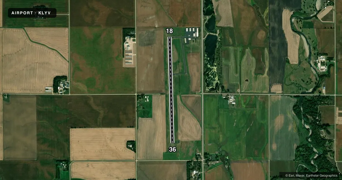
Airport sketch
Runways drawn to scale from FAA survey coordinates, rendered over satellite imagery. Not for navigation.
Approaches & charts
Services on the field
Fuel grades, oxygen, maintenance, ramp storage and lighting — as declared to the FAA by the airport operator.
Fuel & services
- Fuel
- 100LLA
- Oxygen (bottled)
- Not available
- Oxygen (bulk)
- Not available
- Airframe repair
- Major
- Power plant repair
- Major
- Other services
- AGRI
Ramp & ground
- Transient storage
- Tie-down
- Landing fee
- No fee published
- Customs
- Not available
- Lighting schedule
- SEE RMK
- Beacon schedule
- SS-SR
- Beacon
- White / Green (civil land)(WG)
- Wind indicator
- Lighted
- Segmented circle
- No
Fuel & FBOs
Cheapest 100LL and Jet A on the field and nearby. Always confirm with the FBO before taxi.
Airport notes
Surface conditions, obstructions, local procedures, lighting outages and other notes published with each FAA cycle.
General notes
- LRG WATERFOWL INVOF ARPT.
- FOR CD CTC SIOUX FALLS APCH AT 605-336-8651, WHEN APCH CLSD CTC MINNEAPOLIS ARTCC AT 651-463-5588.
Lighting notes
- ABN LWR THAN BLDG NNE.
- ACTVT OR INCR INTST REIL RWY 18 & 36; PAPI RWY 18 & 36; MIRL RWY 18/36 - CTAF. RWY LGT PRESET LOW INTST DUSK-DAWN.
Fuel notes
- 100LLFUEL AVBL H24 SELF SVC VIA CREDIT CARD.
Other notes
- MANAGERARPT FONE.
VFR map & nearby airports
VFR sectional. Tap any ICAO chip to open that airport.
Key facts · KLYV
Answer card- ICAO
- KLYV
- Name
- QUENTIN AANENSON FLD
- Location
- LUVERNE, MINNESOTA
- Elevation
- 1,435 ft MSL
- Traffic pattern altitude
- 2,435 ft MSL (1,000 AGL)
- Control tower
- Non-towered (use CTAF)
- Total runways
- 1
- Longest runway
- 18/36 · 4,200 ft
- Published ILS approaches
- 0
- Published frequencies
- 4
- Magnetic variation
- 3°
- Current flight rules
- MVFR
- Current wind
- 000° at 0 kt
- Favored runway now
- –
Quentin Aanenson Fld sits in Luverne, Minnesota. The field elevation is 1,435 ft MSL. It has one runway, 18/36, at 4,200 ft of asphalt. There is no control tower. Pattern altitude is not published, so use the standard 1,000 ft AGL for light piston traffic unless the current chart supplement says otherwise.
No ILS approaches are published here. For radio work, CTAF and UNICOM are both 122.7. Sioux Falls Approach handles clearance delivery, with the published contact numbers in the Chart Supplement. If approach is closed, Minneapolis ARTCC is the backup contact.
Tailwinds Aircraft Services is on the field. It carries 100LL and Jet A Prist. Fuel is available 24 hours a day through self-serve credit card. Runway lighting is pilot-controlled on 18/36. The lights are preset to low intensity from dusk to dawn. The PAPI and runway end identifier lights are also active on both ends.
First-time arrivals should plan for the field elevation and keep an eye out for large waterfowl in the area. The abandoned beacon is lower than the building to the north-northeast, which is worth a look on taxi in and out. Check the current FAA Chart Supplement for any updated remarks before you fly in.