METAR & TAF KPQN
Current METAR
Observed 16:15Z
KPQN 271615Z AUTO 01005KT 10SM CLR 30/18 A2987 RMK AO2 T02970181
- Wind
- 010° @ 5 kt
- Visibility
- 10 SM
- Temp / Dew
- 30°C / 18°C
- Altimeter
- 29.87 inHg
- Clouds
- CLR
- Density alt
- 4,016 ft
- Ceiling
- Unlimited
- Rules
- VFR
Airport info & contacts
Manager on record, flight service, ARTCC, attendance schedule and pattern altitude — published by the FAA and refreshed every 28 days.
Location
- From city
- 1 NM SE
- VFR sectional
- OMAHA
- ARTCC
- ZMP · MINNEAPOLIS
- NOTAM facility
- PQN (NOTAM-D)
Airport manager
- Name
- ROBERT DYKSTRA
- Phone
- 605-360-2233
- Address
- 1302 13TH ST SE, PIPESTONE MN 56164-2294
Flight service · Hours
- FSS PNM
- PRINCETON1-800-WX-BRIEF
- Attendance
- MON-FRI · 0800-1700
Frequencies
Tap any row to copy the frequency to your clipboard.
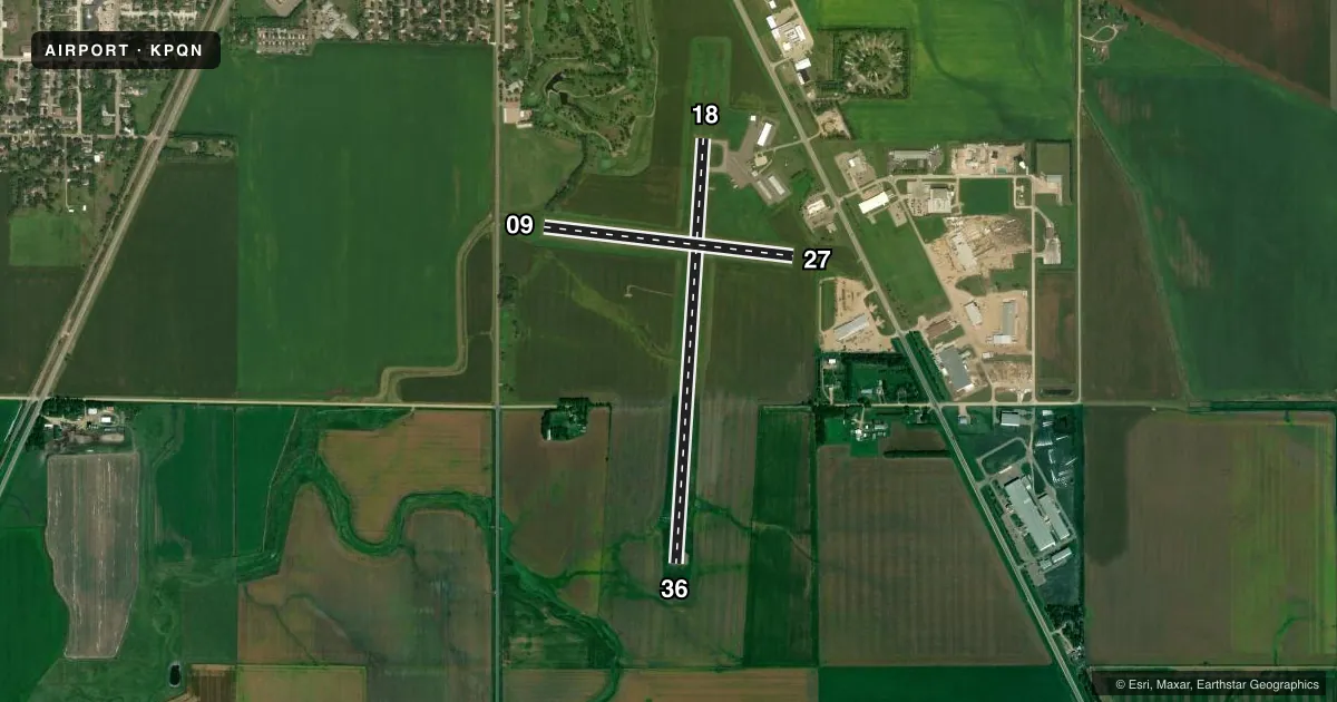
Runways & pattern
Full pagePattern entry · RWY 36
LEFT TRAFFIC| Runway | Heading (°M) | Length | Surface | Traffic |
|---|---|---|---|---|
| 18/36Favored | 181° / 1° | 4,306 ft | ASPH | Standard L |
| 09/27 | 94° / 274° | 2,522 ft | TURF | Standard L |
Runway end performance
| End | TORA | TODA | ASDA | LDA | VGSI | Approach lights | Obstruction |
|---|---|---|---|---|---|---|---|
| 18 | — | — | — | — | PAPI 4-box left(3°) | — | 13', brush, 412' from thr, 145' R of cntrln, slope 16 |
| 36 | — | — | — | — | PAPI 4-box left(3°) | — | — |
| 27 | — | — | — | — | — | — | 10', crops, 22' from thr, 0' R of cntrln, slope 2 |
Declared distances in feet. TORA = takeoff run available, TODA = takeoff distance, ASDA = accelerate-stop, LDA = landing distance.
Airport sketch
Runways drawn to scale from FAA survey coordinates, rendered over satellite imagery. Not for navigation.
Approaches & charts
Services on the field
Fuel grades, oxygen, maintenance, ramp storage and lighting — as declared to the FAA by the airport operator.
Fuel & services
- Fuel
- 100LLA
- Oxygen (bottled)
- Not available
- Oxygen (bulk)
- Not available
- Airframe repair
- Not available
- Power plant repair
- Not available
- Other services
- AGRI,SALES
Ramp & ground
- Transient storage
- Tie-down
- Hangar
- Landing fee
- No fee published
- Customs
- Not available
- Lighting schedule
- SEE RMK
- Beacon schedule
- SS-SR
- Beacon
- White / Green (civil land)(WG)
- Wind indicator
- Lighted
- Segmented circle
- No
Fuel & FBOs
Cheapest 100LL and Jet A on the field and nearby. Always confirm with the FBO before taxi.
Airport notes
Surface conditions, obstructions, local procedures, lighting outages and other notes published with each FAA cycle.
General notes
- GCO AVBL ON FREQ 121.725 THRU MINNEAPOLIS ARTCC & FLT SVCS.
- FOR CD IF UNA VIA GCO CTC MINNEAPOLIS ARTCC AT 651-463-5588.
Lighting notes
- ACTVT REIL RWY 18 & 36; PAPI RWY 18 & 36; MIRL RWY 18/36 - CTAF.
Fuel notes
- 100LLFUEL AVBL H24 VIA CREDIT CARD.
Runway surface & condition
- 09/27NOT PLOWED WINTER MONTHS.
Approach & departure obstructions
- 09YELLOW CONES.
- 27YELLOW CONES.
Other notes
- FOR HNGR CALL AMGR OR OWNER.
- MANAGERRDYKS@AOL.COM.
VFR map & nearby airports
VFR sectional. Tap any ICAO chip to open that airport.
Key facts · KPQN
Answer card- ICAO
- KPQN
- Name
- PIPESTONE MUNI
- Location
- PIPESTONE, MINNESOTA
- Elevation
- 1,736.8 ft MSL
- Traffic pattern altitude
- 2,736.8 ft MSL (1,000 AGL)
- Control tower
- Non-towered (use CTAF)
- Total runways
- 2
- Longest runway
- 18/36 · 4,306 ft
- Published ILS approaches
- 0
- Published frequencies
- 2
- Magnetic variation
- 3°
- Current flight rules
- VFR
- Current wind
- 010° at 5 kt
- Favored runway now
- RWY 36
Pipestone Muni sits in Pipestone, Minnesota. Field elevation is 1,736.7 ft MSL. The airport has two runways. The longest is 18/36 at 4,306 ft on asphalt. The other runway is 09/27 at 2,539 ft on turf. There is no control tower. CTAF and UNICOM are both 122.8.
No ILS approaches are published here. Runway 18 and Runway 36 have REIL lighting, PAPI and medium intensity runway lighting controlled by CTAF. Runway 09/27 is not plowed during winter months. Yellow cones mark Runway 09 and Runway 27. Pattern altitude is not published, so use the standard 1,000 ft AGL for light piston traffic unless the current Chart Supplement says otherwise.
Country Aire is on the field. It carries 100LL and Jet A. 100LL is available 24 hours via credit card. If you need hangar information, contact the airport manager or owner. The airport manager can be reached at rdyks@aol.com. For clearance delivery if GCO is not usable, contact Minneapolis ARTCC at 651-463-5588. This is a non-towered field with a modest runway setup. Plan your radio work early. Verify current conditions before you go.