METAR & TAF 63Y
63Y does not publish a METAR.
Showing the nearest reporting station: KMML (SOUTHWEST MINNESOTA RGNL MARSHALL/RYAN FLD) · 17.1 NM away. Conditions at 63Y may differ.
METAR · KMML
Observed 14:56Z
KMML 271456Z AUTO 30008KT 9SM CLR 26/18 A2982 RMK AO2 SLP089 T02610178 51008
- Wind
- 300° @ 8 kt
- Visibility
- 9 SM
- Temp / Dew
- 26°C / 18°C
- Altimeter
- 29.82 inHg
- Clouds
- CLR
- Density alt
- 3,604 ft
- Ceiling
- Unlimited
- Rules
- VFR
Airport info & contacts
Manager on record, flight service, ARTCC, attendance schedule and pattern altitude — published by the FAA and refreshed every 28 days.
Location
- From city
- 1 NM NW
- VFR sectional
- OMAHA
- ARTCC
- ZMP · MINNEAPOLIS
- NOTAM facility
- PNM (NOTAM-D)
Airport manager
- Name
- TERRY EAST
- Phone
- 507-247-5556
- Address
- CITY OF TYLER, 230 N TYLER ST, TYLER MN 56178
Flight service · Hours
- FSS PNM
- PRINCETON1-800-WX-BRIEF
- Attendance
- Unattended
Frequencies
Tap any row to copy the frequency to your clipboard.
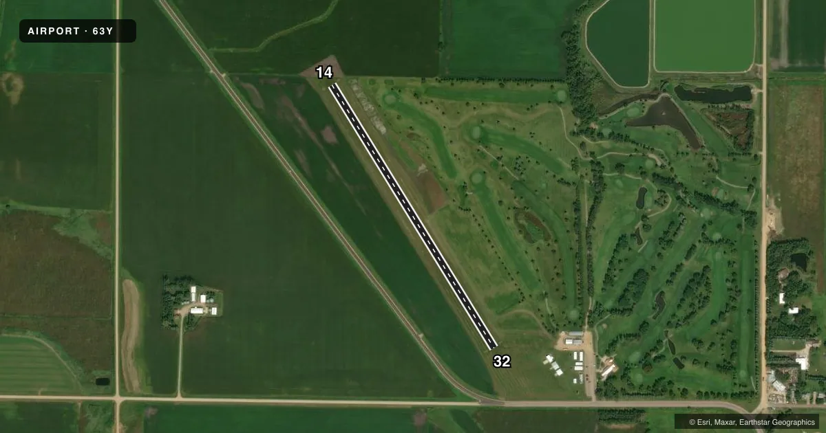
Runways & pattern
Full pagePattern entry · RWY 32
LEFT TRAFFICAirport sketch
Runways drawn to scale from FAA survey coordinates, rendered over satellite imagery. Not for navigation.
Approaches & charts
Services on the field
Fuel grades, oxygen, maintenance, ramp storage and lighting — as declared to the FAA by the airport operator.
Fuel & services
- Fuel
- Not available
- Oxygen (bottled)
- Not available
- Oxygen (bulk)
- Not available
- Airframe repair
- Not available
- Power plant repair
- Not available
- Other services
- AGRI
Ramp & ground
- Transient storage
- Tie-down
- Landing fee
- No fee published
- Customs
- Not available
- Lighting schedule
- SS-SR
- Beacon schedule
- SS-SR
- Beacon
- White / Green (civil land)(WG)
- Wind indicator
- Lighted
- Segmented circle
- No
Fuel & FBOs
Cheapest 100LL and Jet A on the field and nearby. Always confirm with the FBO before taxi.
Airport notes
Surface conditions, obstructions, local procedures, lighting outages and other notes published with each FAA cycle.
General notes
- ARPT CLSD WINTER MONTHS. CK NOTAMS FOR STATUS.
- FOR CD CTC MINNEAPOLIS ARTCC AT 651-463-5588.
Approach & departure obstructions
- 14YELLOW CONES.
- 32YELLOW CONES.
Other notes
- ESTABD BFR 1959.
- 14/32BARE SPOTS, DEPRESSIONS & HOLES.
VFR map & nearby airports
VFR sectional. Tap any ICAO chip to open that airport.
Key facts · 63Y
Answer card- ICAO
- 63Y
- Name
- TYLER MUNI
- Location
- TYLER, MINNESOTA
- Elevation
- 1,742 ft MSL
- Traffic pattern altitude
- 2,742 ft MSL (1,000 AGL)
- Control tower
- Non-towered (use CTAF)
- Total runways
- 1
- Longest runway
- 14/32 · 2,517 ft
- Published ILS approaches
- 0
- Published frequencies
- 1
- Magnetic variation
- –
- Current flight rules
- VFR
- Current wind
- 300° at 8 kt
- Favored runway now
- RWY 32
Tyler Muni (63Y) sits in Tyler, Minnesota. The field elevation is 1,742 ft MSL. It has one runway. Runway 14/32 is 2,517 ft long and is turf. No tower is published, so use CTAF 122.9 for local traffic calls. No ILS approaches are published here.
The pattern altitude is not published. Use the standard 1,000 ft AGL pattern unless the current Chart Supplement or local procedures say otherwise. This field is a simple turf strip, but the published remarks matter. The airport is closed during winter months. Check NOTAMs before you go. The runway surface is reported with bare spots, depressions and holes. Runway 14 and Runway 32 are both marked with yellow cones. That is a good cue to keep your scan tight on rollout and during taxi.
There are no on-field FBOs listed. Plan fuel and service stops elsewhere. Contact the airport operator or the FBO directly before departure if you need current availability. For clearance delivery, Minneapolis ARTCC is listed in the remarks at 651-463-5588. If you are filing IFR or planning a night arrival, verify the current Chart Supplement and NOTAMs first. This is a small, high-elevation Minnesota strip with no published precision approach support, so treat it as a VFR, daylight, condition-check-before-you-go airport.