METAR & TAF KTKC
Current METAR
Observed 13:35Z
KTKC 271335Z AUTO 31007KT 10SM CLR 25/22 A2982 RMK AO2
- Wind
- 310° @ 7 kt
- Visibility
- 10 SM
- Temp / Dew
- 25°C / 22°C
- Altimeter
- 29.82 inHg
- Clouds
- CLR
- Density alt
- 2,980 ft
- Ceiling
- Unlimited
- Rules
- VFR
Airport info & contacts
Manager on record, flight service, ARTCC, attendance schedule and pattern altitude — published by the FAA and refreshed every 28 days.
Location
- From city
- 1 NM NE
- VFR sectional
- OMAHA
- ARTCC
- ZMP · MINNEAPOLIS
- NOTAM facility
- TKC (NOTAM-D)
Airport manager
- Name
- SHANE DANIELS
- Phone
- 507-629-5545
- Address
- 336 MORGAN ST, PO BOX 1218, TRACY MN 56175-0218
Flight service · Hours
- FSS PNM
- PRINCETON1-800-WX-BRIEF
- Attendance
- Unattended
Frequencies
Tap any row to copy the frequency to your clipboard.
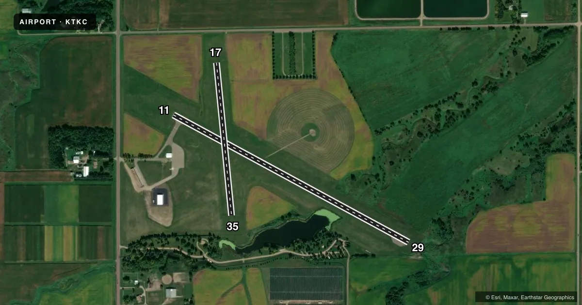
Runways & pattern
Full pagePattern entry · RWY 29
LEFT TRAFFIC| Runway | Heading (°M) | Length | Surface | Traffic |
|---|---|---|---|---|
| 11/29Favored | 113° / 293° | 3,098 ft | ASPH | Standard L |
| 17/35 | 169° / 349° | 1,778 ft | TURF | Standard L |
Runway end performance
| End | TORA | TODA | ASDA | LDA | VGSI | Approach lights | Obstruction |
|---|---|---|---|---|---|---|---|
| 11 | — | — | — | — | — | — | 26', road, 483' from thr, 286' R of cntrln, slope 10 |
Declared distances in feet. TORA = takeoff run available, TODA = takeoff distance, ASDA = accelerate-stop, LDA = landing distance.
Airport sketch
Runways drawn to scale from FAA survey coordinates, rendered over satellite imagery. Not for navigation.
Approaches & charts
Services on the field
Fuel grades, oxygen, maintenance, ramp storage and lighting — as declared to the FAA by the airport operator.
Fuel & services
- Fuel
- 100LL
- Oxygen (bottled)
- Not available
- Oxygen (bulk)
- Not available
- Airframe repair
- Not available
- Power plant repair
- Not available
- Other services
- AGRI
Ramp & ground
- Transient storage
- Tie-down
- Landing fee
- No fee published
- Customs
- Not available
- Lighting schedule
- SEE RMK
- Beacon schedule
- SS-SR
- Beacon
- White / Green (civil land)(WG)
- Wind indicator
- Lighted
- Segmented circle
- No
Fuel & FBOs
Cheapest 100LL and Jet A on the field and nearby. Always confirm with the FBO before taxi.
Airport notes
Surface conditions, obstructions, local procedures, lighting outages and other notes published with each FAA cycle.
General notes
- FOR CD CTC MINNEAPOLIS ARTCC AT 651-463-5588.
Lighting notes
- INCR INTST MIRL RWY 11/29 - CTAF. MIRL RWY 11/29 PRESET LOW INTST.
Fuel notes
- 100LL100LL AVBL H24 VIA CREDIT CARD.
Runway surface & condition
- 17/35NOT PLOWED WINTER MONTHS.
Approach & departure obstructions
- 29LN OF 7 FT BRUSH, 107 FT FM RWY END, LEFT SIDE OF CNTRLN.
- 17YELLOW CONES.
- 35YELLOW CONES.
Other notes
- MANAGERSDANIELS@TRACYMN.ORG.
VFR map & nearby airports
VFR sectional. Tap any ICAO chip to open that airport.
Key facts · KTKC
Answer card- ICAO
- KTKC
- Name
- TRACY MUNI
- Location
- TRACY, MINNESOTA
- Elevation
- 1,335.7 ft MSL
- Traffic pattern altitude
- 2,335.7 ft MSL (1,000 AGL)
- Control tower
- Non-towered (use CTAF)
- Total runways
- 2
- Longest runway
- 11/29 · 3,098 ft
- Published ILS approaches
- 0
- Published frequencies
- 1
- Magnetic variation
- 5°
- Current flight rules
- VFR
- Current wind
- 310° at 7 kt
- Favored runway now
- RWY 29
Tracy Muni sits in Tracy, Minnesota. The field elevation is 1,335.7 ft MSL. It has 2 runways. The longest is runway 11/29 at 3,098 ft. There is no control tower, so expect CTAF traffic on 122.9 and self-announced position reports. No ILS approaches are published here.
The pattern altitude is not published. Use the standard 1,000 ft AGL pattern unless the current Chart Supplement or local traffic calls for something different. Runway 11/29 has increased intensity lights that are controlled on CTAF. The lights are preset to low intensity. Runway 17/35 is turf at 1,778 ft. Yellow cones mark the ends of runways 17 and 35. Runways 17 and 35 are not plowed in winter, so plan for seasonal surface limits.
There are no on-field FBOs listed. 100LL is available 24 hours a day by credit card. One published obstruction note says there is a line of 7 ft brush 107 ft from the runway end on the left side of the centerline. For clearance delivery, contact Minneapolis ARTCC at 651-463-5588. The airport manager contact is sdaniels@tracymn.org. With no tower and no ILS, a first-time pilot should brief the turf condition. Brief the lighting use. Brief the runway length before arrival.