METAR & TAF KMWM
Current METAR
Observed 01:55Z
KMWM 130155Z AUTO 34024G34KT 10SM OVC100 23/12 A2984 RMK AO2
- Wind
- 340° @ 24G34 kt
- Visibility
- 10 SM
- Temp / Dew
- 23°C / 12°C
- Altimeter
- 29.84 inHg
- Clouds
- OVC
- Density alt
- 2,809 ft
- Ceiling
- 10,000 ft AGL
- Rules
- VFR
Airport info & contacts
Manager on record, flight service, ARTCC, attendance schedule and pattern altitude — published by the FAA and refreshed every 28 days.
Location
- From city
- 3 NM N
- VFR sectional
- OMAHA
- ARTCC
- ZMP · MINNEAPOLIS
- NOTAM facility
- MWM (NOTAM-D)
Airport manager
- Name
- SCOTT BENSON
- Phone
- 507-822-0782
- Address
- 444 9TH ST., PO BOX 38, WINDOM MN 56101
Flight service · Hours
- FSS PNM
- PRINCETON1-800-WX-BRIEF
- Attendance
- Unattended
Frequencies
Tap any row to copy the frequency to your clipboard.
Runways & pattern
Full pagePattern entry · RWY 35
LEFT TRAFFICRunway end performance
| End | TORA | TODA | ASDA | LDA | VGSI | Approach lights | Obstruction |
|---|---|---|---|---|---|---|---|
| 17 | — | — | — | — | PAPI 4-box left(3°) | — | — |
| 35 | — | — | — | — | PAPI 4-box left(3°) | — | — |
Declared distances in feet. TORA = takeoff run available, TODA = takeoff distance, ASDA = accelerate-stop, LDA = landing distance.
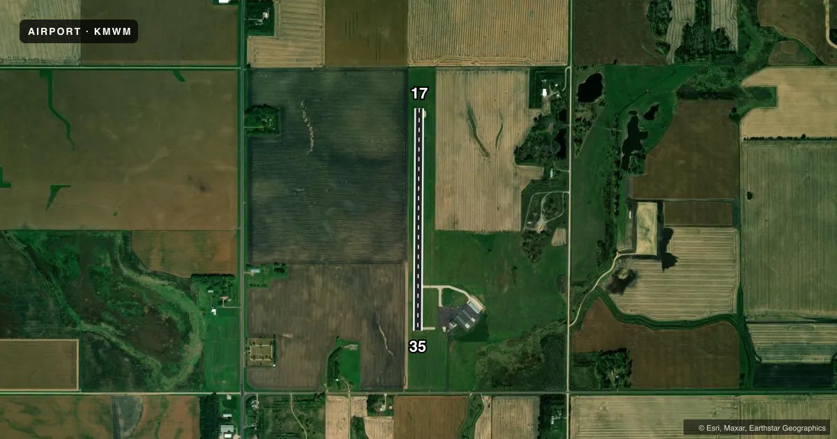
Airport sketch
Runways drawn to scale from FAA survey coordinates, rendered over satellite imagery. Not for navigation.
Approaches & charts
Services on the field
Fuel grades, oxygen, maintenance, ramp storage and lighting — as declared to the FAA by the airport operator.
Fuel & services
- Fuel
- 100LLA
- Oxygen (bottled)
- Not available
- Oxygen (bulk)
- Not available
- Airframe repair
- Not available
- Power plant repair
- Not available
- Other services
- AGRI
Ramp & ground
- Transient storage
- Tie-down
- Landing fee
- No fee published
- Customs
- Not available
- Lighting schedule
- SEE RMK
- Beacon schedule
- SS-SR
- Beacon
- White / Green (civil land)(WG)
- Wind indicator
- Lighted
- Segmented circle
- No
Fuel & FBOs
Cheapest 100LL and Jet A on the field and nearby. Always confirm with the FBO before taxi.
Airport notes
Surface conditions, obstructions, local procedures, lighting outages and other notes published with each FAA cycle.
General notes
- BIRDS ON & INVOF ARPT.
- FOR CD CTC MINNEAPOLIS ARTCC AT 651-463-5588.
Lighting notes
- ACTVT REIL RWY 17 & 35; PAPI RWY 17 & 35; MIRL RWY 17/35 - CTAF.
Fuel notes
- 100LLFUEL AVAIL 24 HRS WITH CREDIT CARD.
Runway surface & condition
- 17/35RWY 17/35 NSTD MIRL & THLD LIGHT CONFIG FOR RWYS SERVED BY IAPS
Approach & departure obstructions
- 17RWY 17 HAS 2 FT CROPS 59 FT FROM RWY END AND ON BOTH SIDES OF THE EXTENDED CNTRLN.
Other notes
- PROVIDED ANY OBSTRUCTION IN RY APCH SLOPE BE REMOVED OR LOWERED TO PROVIDE 20:1 CLEARANCE. LTR OF AGREEMENT BTWN SKYHAVEN & PHEASANT RUN ARPTS REFERRING TO TRAFFIC PATTERN.
VFR map & nearby airports
VFR sectional. Tap any ICAO chip to open that airport.
Key facts · KMWM
Answer card- ICAO
- KMWM
- Name
- WINDOM MUNI
- Location
- WINDOM, MINNESOTA
- Elevation
- 1,410.8 ft MSL
- Traffic pattern altitude
- 2,410.8 ft MSL (1,000 AGL)
- Control tower
- Non-towered (use CTAF)
- Total runways
- 1
- Longest runway
- 17/35 · 3,598 ft
- Published ILS approaches
- 0
- Published frequencies
- 1
- Magnetic variation
- 3°
- Current flight rules
- VFR
- Current wind
- 340° at 24 kt
- Favored runway now
- RWY 35
Windom Muni sits in Windom, Minnesota. Field elevation is 1,410.8 ft MSL. The airport has one runway, 17/35, which is 3,598 ft long. There is no control tower. CTAF is 122.9. No ILS approaches are published here.
The pattern altitude is not published in the facts, so use the standard 1,000 ft AGL for light piston operations unless the current Chart Supplement says otherwise. The field has one on-field FBO, Windom Municipal Airport. It carries 100LL and Jet A. Fuel is available 24 hours with credit card. Runway 17 has a small crop obstruction near the departure end. The published remarks also note birds in and near the airport. Runway 17/35 has medium intensity lighting, runway end identifier lights and PAPI on both ends. The lights are controlled by CTAF.
For a first-time arrival, the main things to watch are the nonstandard lighting setup, the obstruction note on runway 17 and the bird activity. Clearance delivery is handled through Minneapolis ARTCC if you need it. Check the current Chart Supplement for any updated pattern, lighting, or operational notes before you go.