METAR & TAF D42
D42 does not publish a METAR.
Showing the nearest reporting station: KRWF (REDWOOD FALLS MUNI) · 19.3 NM away. Conditions at D42 may differ.
METAR · KRWF
Observed 18:53Z
KRWF 121853Z AUTO 24017G25KT 10SM FEW065 25/11 A2987 RMK AO2 PK WND 25027/1810 SLP111 T02500111
- Wind
- 240° @ 17G25 kt
- Visibility
- 10 SM
- Temp / Dew
- 25°C / 11°C
- Altimeter
- 29.87 inHg
- Clouds
- FEW
- Density alt
- 2,593 ft
- Ceiling
- Unlimited
- Rules
- VFR
Airport info & contacts
Manager on record, flight service, ARTCC, attendance schedule and pattern altitude — published by the FAA and refreshed every 28 days.
Location
- From city
- 1 NM SW
- VFR sectional
- OMAHA
- ARTCC
- ZMP · MINNEAPOLIS
- NOTAM facility
- PNM (NOTAM-D)
Airport manager
- Name
- JUSTTINA ERICKSON
- Phone
- 507-723-3500
- Address
- 2 E CENTRAL ST, SPRINGFIELD MN 56087
Flight service · Hours
- FSS PNM
- PRINCETON1-800-WX-BRIEF
- Attendance
- Unattended
Frequencies
Tap any row to copy the frequency to your clipboard.
Runways & pattern
Full pagePattern entry · RWY 31
LEFT TRAFFICRunway end performance
| End | TORA | TODA | ASDA | LDA | VGSI | Approach lights | Obstruction |
|---|---|---|---|---|---|---|---|
| 13 | — | — | — | — | PAPI 2-box left(3°) | — | — |
| 31 | — | — | — | — | PAPI 2-box left(3°) | — | — |
Declared distances in feet. TORA = takeoff run available, TODA = takeoff distance, ASDA = accelerate-stop, LDA = landing distance.
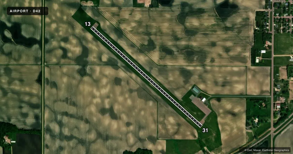
Airport sketch
Runways drawn to scale from FAA survey coordinates, rendered over satellite imagery. Not for navigation.
Approaches & charts
Services on the field
Fuel grades, oxygen, maintenance, ramp storage and lighting — as declared to the FAA by the airport operator.
Fuel & services
- Fuel
- 100LL
- Oxygen (bottled)
- Not available
- Oxygen (bulk)
- Not available
- Airframe repair
- Not available
- Power plant repair
- Not available
Ramp & ground
- Transient storage
- Tie-down
- Hangar
- Landing fee
- No fee published
- Customs
- Not available
- Lighting schedule
- SEE RMK
- Beacon schedule
- SS-SR
- Beacon
- White / Green (civil land)(WG)
- Wind indicator
- Lighted
- Segmented circle
- No
Fuel & FBOs
Cheapest 100LL and Jet A on the field and nearby. Always confirm with the FBO before taxi.
Airport notes
Surface conditions, obstructions, local procedures, lighting outages and other notes published with each FAA cycle.
General notes
- ULTRALIGHT TRAFFIC ON & INVOF ARPT.
- FOR CD CTC MINNEAPOLIS ARTCC AT 651-463-5588.
Lighting notes
- MIRL SS-SR, ACTVT MIRL RWY 13/31, REIL RWY 13/31, AND PAPI RWY 13/31 - CTAF.
Fuel notes
- 100LLSELF SVC AVBL H24 VIA CREDIT CARD.
Runway surface & condition
- 13/31NO CAUTION ZONE LIGHTING PRESENT FOR LAST HALF OF RWY IN BOTH DIRECTIONS
Other notes
- CTC 507-723-3500 FOR HNGR.
- 3FOR SVC CALL 507-723-3524.
VFR map & nearby airports
VFR sectional. Tap any ICAO chip to open that airport.
Key facts · D42
Answer card- ICAO
- D42
- Name
- SPRINGFIELD MUNI
- Location
- SPRINGFIELD, MINNESOTA
- Elevation
- 1,073 ft MSL
- Traffic pattern altitude
- 2,073 ft MSL (1,000 AGL)
- Control tower
- Non-towered (use CTAF)
- Total runways
- 1
- Longest runway
- 13/31 · 3,402 ft
- Published ILS approaches
- 0
- Published frequencies
- 2
- Magnetic variation
- 2°
- Current flight rules
- VFR
- Current wind
- 240° at 17 kt
- Favored runway now
- RWY 31
Springfield Muni sits in Springfield, Minnesota. The field elevation is 1,073 ft MSL. It has one runway, 13/31, which is 3,402 ft long and paved with asphalt. There is no control tower. CTAF and UNICOM are both 122.8.
No ILS approaches are published here. Pattern altitude is not published, so use the standard 1,000 ft AGL for light piston traffic unless the current Chart Supplement says otherwise. The airport uses medium intensity runway lights. They operate from sunset to sunrise. The runway end identifier lights and PAPI for runway 13/31 are activated by CTAF.
Springfield Municipal Airport is the on-field FBO. It carries 100LL. Self-serve 100LL is available 24 hours by credit card. For service, the published number is 507-723-3524. Ultralight traffic is also on and near the airport, so keep a sharp scan in the pattern and on taxi. For clearance delivery, contact Minneapolis ARTCC at 651-463-5588. If you need hangar info, the published contact is 507-723-3500.