METAR & TAF KRWF
Current METAR
Observed 22:53Z
KRWF 272253Z AUTO 33010KT 8SM CLR 31/22 A2977 RMK AO2 SLP072 T03110222
- Wind
- 330° @ 10 kt
- Visibility
- 8 SM
- Temp / Dew
- 31°C / 22°C
- Altimeter
- 29.77 inHg
- Clouds
- CLR
- Density alt
- 3,375 ft
- Ceiling
- Unlimited
- Rules
- VFR
Airport info & contacts
Manager on record, flight service, ARTCC, attendance schedule and pattern altitude — published by the FAA and refreshed every 28 days.
Location
- From city
- 2 NM NE
- VFR sectional
- TWIN CITIES
- ARTCC
- ZMP · MINNEAPOLIS
- NOTAM facility
- RWF (NOTAM-D)
Airport manager
- Name
- WINSTON VENABLE
- Phone
- 507-430-8872
- Address
- 500 AIRPORT RD, REDWOOD FALLS MN 56283-2848
Flight service · Hours
- FSS PNM
- PRINCETON1-800-WX-BRIEF
- Attendance
- MON-FRI · 0800-1700
Frequencies
Tap any row to copy the frequency to your clipboard.
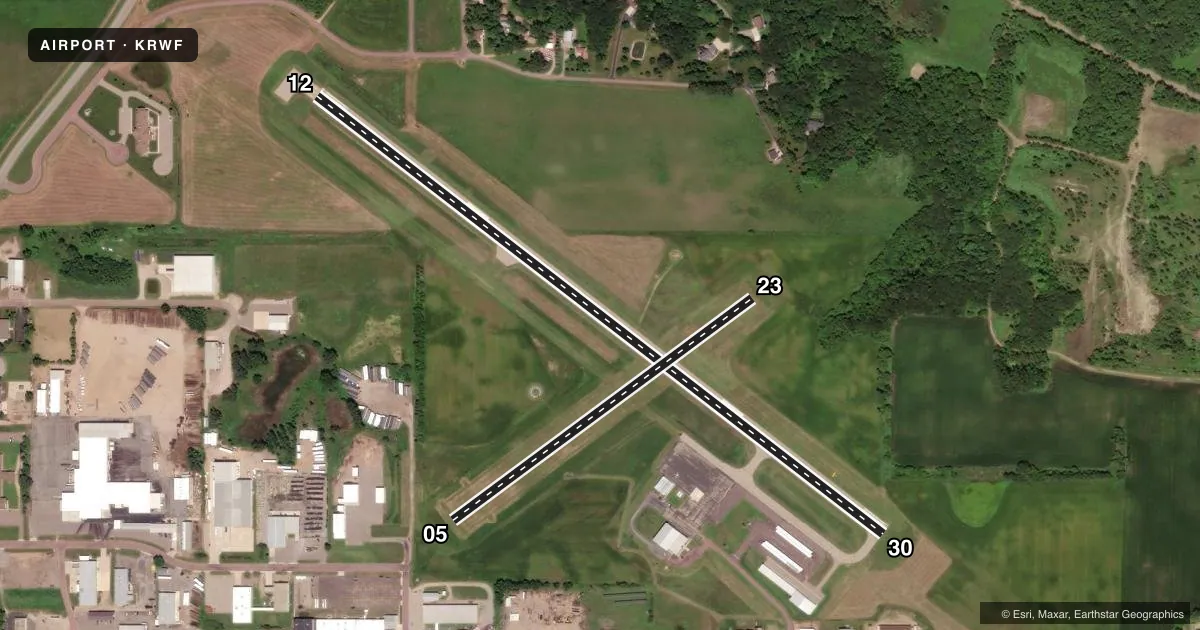
Runways & pattern
Full pagePattern entry · RWY 30
LEFT TRAFFIC| Runway | Heading (°M) | Length | Surface | Traffic |
|---|---|---|---|---|
| 12/30Favored | 124° / 304° | 4,001 ft | ASPH | Standard L |
| 05/23 | 50° / 230° | 2,081 ft | TURF | Standard L |
Runway end performance
| End | TORA | TODA | ASDA | LDA | VGSI | Approach lights | Obstruction |
|---|---|---|---|---|---|---|---|
| 12 | — | — | — | — | PAPI 2-box left(3°) | — | — |
| 30 | — | — | — | — | PAPI 2-box left(3°) | — | — |
| 05 | — | — | — | — | — | — | 18', road, 188' from thr, 134' R of cntrln, slope 10 |
Declared distances in feet. TORA = takeoff run available, TODA = takeoff distance, ASDA = accelerate-stop, LDA = landing distance.
Airport sketch
Runways drawn to scale from FAA survey coordinates, rendered over satellite imagery. Not for navigation.
Approaches & charts
Services on the field
Fuel grades, oxygen, maintenance, ramp storage and lighting — as declared to the FAA by the airport operator.
Fuel & services
- Fuel
- 100LLA
- Oxygen (bottled)
- Not available
- Oxygen (bulk)
- Not available
- Airframe repair
- Not available
- Power plant repair
- Not available
- Other services
- SURV
Ramp & ground
- Transient storage
- Tie-down
- Hangar
- Landing fee
- No fee published
- Customs
- Not available
- Lighting schedule
- SEE RMK
- Beacon schedule
- SS-SR
- Beacon
- White / Green (civil land)(WG)
- Wind indicator
- Lighted
- Segmented circle
- Yes
Fuel & FBOs
Cheapest 100LL and Jet A on the field and nearby. Always confirm with the FBO before taxi.
Airport notes
Surface conditions, obstructions, local procedures, lighting outages and other notes published with each FAA cycle.
General notes
- DEER & WATERFOWL INVOF ARPT.
- FOR CD IF UNA TO CTC ON FSS FREQ, CTC MINNEAPOLIS ARTCC AT 651-463-5588.
Lighting notes
- ACTVT OR INCR INTST REIL RWY 12 & 30; PAPI RWY 12 & 30; MIRL RWY 12/30 - CTAF. MIRL RWY 12/30 PRESET LOW INTST.
Fuel notes
- 100LL100LL & JET A AVBL H24 SELF SVC VIA CREDIT CARD.
Runway surface & condition
- 05/23NOT PLOWED WINTER MONTHS.
Approach & departure obstructions
- 306 FT CROPS, 98 FT DIST, 138 FT R.
- 05YELLOW CONES.
- 23YELLOW CONES.
- 12PAPI UNUSBL BYD 7 DEGS RIGHT OF CNTRLN.
- 30PAPI UNUSBL BYD 5 DEGS RIGHT OF CNTRLN.
Other notes
- MANAGERCELL.
VFR map & nearby airports
VFR sectional. Tap any ICAO chip to open that airport.
Key facts · KRWF
Answer card- ICAO
- KRWF
- Name
- REDWOOD FALLS MUNI
- Location
- REDWOOD FALLS, MINNESOTA
- Elevation
- 1,023.6 ft MSL
- Traffic pattern altitude
- 2,023.6 ft MSL (1,000 AGL)
- Control tower
- Non-towered (use CTAF)
- Total runways
- 2
- Longest runway
- 12/30 · 4,001 ft
- Published ILS approaches
- 0
- Published frequencies
- 2
- Magnetic variation
- 4°
- Current flight rules
- VFR
- Current wind
- 330° at 10 kt
- Favored runway now
- RWY 30
Redwood Falls Muni (KRWF) sits in Redwood Falls, Minnesota. Field elevation is 1,023.6 ft MSL. The airport has two runways. The longest is Runway 12/30 at 4,001 ft asphalt. Runway 05/23 is 2,081 ft turf. There is no control tower. CTAF and UNICOM are both 123.0.
No ILS approaches are published here. Pattern altitude is not published, so use the standard 1,000 ft AGL for light piston operations unless the current Chart Supplement says otherwise. The on-field FBO is Redwood Falls Municipal Airport. It carries 100LL and Jet A. Fuel is available 24 hours a day by self-service credit card.
A few field notes matter here. Runway 12 and Runway 30 lighting is controlled by CTAF. The runway lights are preset to low intensity. Runway 30 has a PAPI limit beyond 5 degrees right of centerline. Runway 12 has a PAPI limit beyond 7 degrees right of centerline. Runways 05 and 23 are not plowed in winter. Yellow cones mark Runways 05 and 23. Deer and waterfowl are reported in the area. If you need clearance delivery and cannot reach Flight Service, contact Minneapolis ARTCC. This is a good field to brief carefully before arrival.