METAR & TAF KGDB
Current METAR
Observed 03:35Z
KGDB 270335Z AUTO 18004KT 10SM CLR A2978 RMK AO2
- Wind
- 180° @ 4 kt
- Visibility
- 10 SM
- Temp / Dew
- —
- Altimeter
- 29.78 inHg
- Clouds
- CLR
- Density alt
- —
- Ceiling
- Unlimited
- Rules
- VFR
Airport info & contacts
Manager on record, flight service, ARTCC, attendance schedule and pattern altitude — published by the FAA and refreshed every 28 days.
Location
- From city
- 4 NM S
- VFR sectional
- TWIN CITIES
- ARTCC
- ZMP · MINNEAPOLIS
- NOTAM facility
- GDB (NOTAM-D)
Airport manager
- Name
- LOIS PROCTOR
- Phone
- 507-476-5939
- Address
- 641 PRENTICE ST, GRANITE FALLS MN 56241-1598
Flight service · Hours
- FSS PNM
- PRINCETON1-800-WX-BRIEF
- Attendance
- Unattended
Frequencies
Tap any row to copy the frequency to your clipboard.
Runways & pattern
Full pagePattern entry · RWY 15
LEFT TRAFFICRunway end performance
| End | TORA | TODA | ASDA | LDA | VGSI | Approach lights | Obstruction |
|---|---|---|---|---|---|---|---|
| 15 | — | — | — | — | PAPI 4-box left(3°) | — | — |
| 33 | — | — | — | — | PAPI 4-box left(3°) | — | 21', road, 239' from thr, 244' R of cntrln, slope 1 |
Declared distances in feet. TORA = takeoff run available, TODA = takeoff distance, ASDA = accelerate-stop, LDA = landing distance.
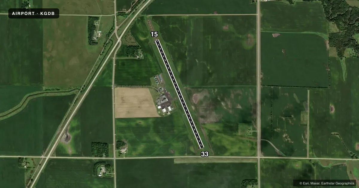
Airport sketch
Runways drawn to scale from FAA survey coordinates, rendered over satellite imagery. Not for navigation.
Approaches & charts
Services on the field
Fuel grades, oxygen, maintenance, ramp storage and lighting — as declared to the FAA by the airport operator.
Fuel & services
- Fuel
- 100LL
- Other services
- AGRI
Ramp & ground
- Transient storage
- Tie-down
- Lighting schedule
- SEE RMK
- Beacon schedule
- SS-SR
- Beacon
- White / Green (civil land)(WG)
- Wind indicator
- Lighted
- Segmented circle
- No
Fuel & FBOs
Cheapest 100LL and Jet A on the field and nearby. Always confirm with the FBO before taxi.
Airport notes
Surface conditions, obstructions, local procedures, lighting outages and other notes published with each FAA cycle.
General notes
- DEER ON & INVOF AIRPORT.
- NOISE SENSITIVE AREA 1.5 MI IN RADIUS OFF NORTH END OF RY 15/33.
- GCO AVBL ON FREQ 121.725 THRU MINNEAPOLIS ARTCC AND PRINCETON FSS.
- ARPT INFO PHONE NUMBER: 320-564-5665.
- FOR CD IF UNA VIA GCO CTC MINNEAPOLIS ARTCC AT 651-463-5588.
Lighting notes
- MIRL RY 15/33 PRESET ON LOW INTST; TO INCR INTST, ACTVT REIL RY 15 & 33 & PAPI RY 15 & 33 - CTAF.
Fuel notes
- 100LLSELF SERVICE FUEL AVAIL 24 HOURS WITH CREDIT CARD.
VFR map & nearby airports
VFR sectional. Tap any ICAO chip to open that airport.
Key facts · KGDB
Answer card- ICAO
- KGDB
- Name
- GRANITE FALLS MUNI/LENZEN-ROE-FAGEN MEML FLD
- Location
- GRANITE FALLS, MINNESOTA
- Elevation
- 1,047.5 ft MSL
- Traffic pattern altitude
- 2,047.5 ft MSL (1,000 AGL)
- Control tower
- Non-towered (use CTAF)
- Total runways
- 1
- Longest runway
- 15/33 · 4,357 ft
- Published ILS approaches
- 0
- Published frequencies
- 2
- Magnetic variation
- 4°
- Current flight rules
- VFR
- Current wind
- 180° at 4 kt
- Favored runway now
- RWY 15
KGDB sits in Granite Falls, Minnesota. The field elevation is 1,047.5 ft MSL. It has one runway, 15/33, at 4,357 ft. The airport is non-towered. CTAF and UNICOM are both 122.8. No ILS approaches are published here.
Pattern altitude is not published. Use the standard 1,000 ft AGL for light piston traffic unless the current Chart Supplement or local procedures say otherwise. The on-field FBO is Granite Falls Municipal Airport. It carries AVGAS 100LL. Self-service fuel is available 24 hours with credit card. The airport information phone number is 320-564-5665. The FBO phone is (320) 564-1831.
A few operational items matter here. Deer are reported on and near the airport. There is a noise sensitive area within 1.5 miles north of runway 15/33. The runway lights are medium intensity and start on low. To increase intensity, activate the runway end identifier lights and the PAPI on runways 15 and 33 via CTAF. If you need clearance delivery and ground communications are not available, contact Minneapolis ARTCC at 651-463-5588. For a first time arrival, plan for a quiet non-towered field with local traffic on 122.8 and check the current Chart Supplement for any changes before you go.