METAR & TAF KBDH
Current METAR
Observed 21:35Z
KBDH 272135Z AUTO 31010KT 8SM CLR 31/24 A2978 RMK AO2
- Wind
- 310° @ 10 kt
- Visibility
- 8 SM
- Temp / Dew
- 31°C / 24°C
- Altimeter
- 29.78 inHg
- Clouds
- CLR
- Density alt
- 3,490 ft
- Ceiling
- Unlimited
- Rules
- VFR
Airport info & contacts
Manager on record, flight service, ARTCC, attendance schedule and pattern altitude — published by the FAA and refreshed every 28 days.
Location
- From city
- 2 NM W
- VFR sectional
- TWIN CITIES
- Pattern altitude
- 974 ft AGL · 2,100 ft MSL
- ARTCC
- ZMP · MINNEAPOLIS
- NOTAM facility
- BDH (NOTAM-D)
Airport manager
- Name
- ERIC RUDNINGEN
- Phone
- 320-894-1872
- Address
- PO BOX 755, 6600 HIGHWAY 40 W, WILLMAR MN 56201-0755
Flight service · Hours
- FSS PNM
- PRINCETON1-800-WX-BRIEF
- Attendance
- 0800-1700
Frequencies
Tap any row to copy the frequency to your clipboard.
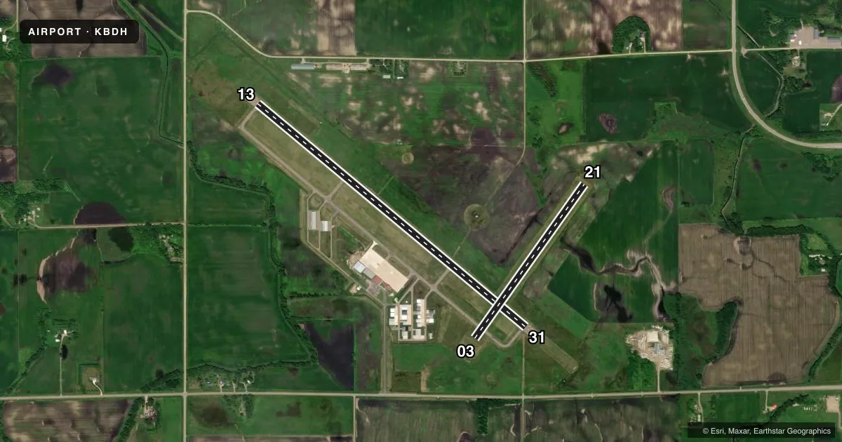
Runways & pattern
Full pagePattern entry · RWY 31
LEFT TRAFFIC| Runway | Heading (°M) | Length | Surface | Traffic |
|---|---|---|---|---|
| 13/31Favored | 126° / 306° | 5,500 ft | ASPH | Standard L |
| 03/21 | 31° / 211° | 2,980 ft | TURF | Standard L |
Runway end performance
| End | TORA | TODA | ASDA | LDA | VGSI | Approach lights | Obstruction |
|---|---|---|---|---|---|---|---|
| 13 | — | — | — | — | PAPI 4-box right(3°) | MALSR | — |
| 31 | — | — | — | — | PAPI 4-box left(3°) | — | — |
Declared distances in feet. TORA = takeoff run available, TODA = takeoff distance, ASDA = accelerate-stop, LDA = landing distance.
Airport sketch
Runways drawn to scale from FAA survey coordinates, rendered over satellite imagery. Not for navigation.
Approaches & charts
ILS · 1
Services on the field
Fuel grades, oxygen, maintenance, ramp storage and lighting — as declared to the FAA by the airport operator.
Fuel & services
- Fuel
- 100LLA
- Oxygen (bulk)
- HIGH/LOW
- Airframe repair
- Major
- Power plant repair
- Major
- Other services
- INSTR,SALES
Ramp & ground
- Transient storage
- Tie-down
- Hangar
- Lighting schedule
- SEE RMK
- Beacon schedule
- SS-SR
- Beacon
- White / Green (civil land)(WG)
- Wind indicator
- Lighted
- Segmented circle
- No
Fuel & FBOs
Cheapest 100LL and Jet A on the field and nearby. Always confirm with the FBO before taxi.
Airport notes
Surface conditions, obstructions, local procedures, lighting outages and other notes published with each FAA cycle.
General notes
- ABNDD ARPT 1 NM EAST.
- FOR CD IF UNA TO CTC ON FSS FREQ, CTC MINNEAPOLIS ARTCC AT 651-463-5588.
Lighting notes
- ACTVT OR INCR INTST MALSR RWY 13; REIL RWY 31; PAPI RWY 13 & 31; HIRL RWY 13/31 - CTAF. HIRL RWY 13/31 PRESET LOW INTST SS-SR.
Fuel notes
- 100LLAVBL H24 SELF SVC VIA CREDIT CARD.
- AFOR SVC AFT HRS CALL FBO AT 320-214-9669.
Runway surface & condition
- 03/21NOT PLOWED WINTER MONTHS.
- 13/31200 FT UNUSBL PAVEMENT BYD RWY, BOTH ENDS.
Approach & departure obstructions
- 03YELLOW CONES.
- 21YELLOW CONES.
Other notes
- FOR TSNT HNGR CALL FBO AT 320-214-9669.
VFR map & nearby airports
VFR sectional. Tap any ICAO chip to open that airport.
Key facts · KBDH
Answer card- ICAO
- KBDH
- Name
- WILLMAR MUNI/JOHN L RICE FLD
- Location
- WILLMAR, MINNESOTA
- Elevation
- 1,126 ft MSL
- Traffic pattern altitude
- 2,100 ft MSL (974 AGL)
- Control tower
- Non-towered (use CTAF)
- Total runways
- 2
- Longest runway
- 13/31 · 5,500 ft
- Published ILS approaches
- 1
- Published frequencies
- 2
- Magnetic variation
- 4°
- Current flight rules
- VFR
- Current wind
- 310° at 10 kt
- Favored runway now
- RWY 31
KBDH sits in Willmar, Minnesota. The field elevation is 1,126 ft MSL. It has two runways. The longest is runway 13/31 at 5,500 ft. Runway 03/21 is turf at 2,980 ft. This is a non-towered airport. CTAF and UNICOM are both 122.8.
The pattern altitude is 974 ft AGL, which is 2,100 ft MSL. Runway 13 has an ILS approach. That makes 13/31 the runway to plan around when the weather goes down. The published remarks also note 200 ft of unusable pavement beyond both ends of runway 13/31. Runways 03/21 are not plowed in winter. Yellow cones mark runway 03 and runway 21.
Oasis Aero is on the field. It carries 100LL and Jet A. 100LL is available 24 hours a day by self-serve credit card. After-hours service and transient hangar requests go through the FBO by phone. The runway lighting on 13/31 is pilot-controlled on CTAF. MALS is on runway 13. REIL is on runway 31. PAPI is available on both 13 and 31. If you need clearance delivery help, the published remarks say to contact Minneapolis ARTCC if Flight Service is not available. Watch for the abandoned airport 1 NM east.