METAR & TAF 6D1
6D1 does not publish a METAR.
Showing the nearest reporting station: KGHW (GLENWOOD MUNI) · 12.7 NM away. Conditions at 6D1 may differ.
METAR · KGHW
Observed 23:35Z
KGHW 272335Z AUTO 32010KT 10SM CLR 30/23 A2980 RMK AO2 T03020233
- Wind
- 320° @ 10 kt
- Visibility
- 10 SM
- Temp / Dew
- 30°C / 23°C
- Altimeter
- 29.80 inHg
- Clouds
- CLR
- Density alt
- 3,566 ft
- Ceiling
- Unlimited
- Rules
- VFR
Airport info & contacts
Manager on record, flight service, ARTCC, attendance schedule and pattern altitude — published by the FAA and refreshed every 28 days.
Location
- From city
- 1 NM SE
- VFR sectional
- TWIN CITIES
- ARTCC
- ZMP · MINNEAPOLIS
- NOTAM facility
- PNM (NOTAM-D)
Airport manager
- Name
- DAVID BOHMER
- Phone
- 320-346-2234
- Address
- 1080 FRONT ST, PO BOX 400, BROOTEN MN 56316-9512
Flight service · Hours
- FSS PNM
- PRINCETON1-800-WX-BRIEF
- Attendance
- Unattended
Frequencies
Tap any row to copy the frequency to your clipboard.
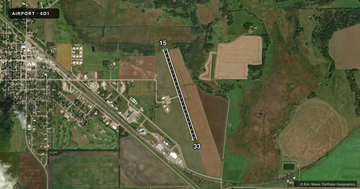
Runways & pattern
Full pagePattern entry · RWY 33
LEFT TRAFFICAirport sketch
Runways drawn to scale from FAA survey coordinates, rendered over satellite imagery. Not for navigation.
Approaches & charts
Services on the field
Fuel grades, oxygen, maintenance, ramp storage and lighting — as declared to the FAA by the airport operator.
Fuel & services
- Fuel
- 100LL
- Other services
- AGRI,SALES
Ramp & ground
- Transient storage
- Tie-down
- Landing fee
- No fee published
- Lighting schedule
- SEE RMK
- Beacon schedule
- SS-SR
- Beacon
- White / Green (civil land)(WG)
- Wind indicator
- Lighted
- Segmented circle
- No
Fuel & FBOs
Cheapest 100LL and Jet A on the field and nearby. Always confirm with the FBO before taxi.
Airport notes
Surface conditions, obstructions, local procedures, lighting outages and other notes published with each FAA cycle.
General notes
- AGRICULTURE OPS DURG SUMMER MONTHS.
- FOR CD CTC MINNEAPOLIS ARTCC AT 651-463-5588.
Lighting notes
- ACTVT OR INCR INTST MIRL RWY 15/33 - CTAF. MIRL RWY 15/33 PRESET LOW INTST.
Fuel notes
- 100LLAVBL H24 VIA CREDIT CARD.
Approach & departure obstructions
- 33CROPS; 5 FT HIGH LCTD 69 FT FM RWY 33 END, 50 FT L OF RWY CNTRLN. PENETRATES THE PRIM SFC BY 3 FT.
Other notes
- PRVDD RWY ENDS ARE ESTABD OR THRS DSPLCD TO PRVD 20:1 CLNC OVR OBSTS IN APCH SFC.
- OWNER320-346-2524
VFR map & nearby airports
VFR sectional. Tap any ICAO chip to open that airport.
Key facts · 6D1
Answer card- ICAO
- 6D1
- Name
- BROOTEN MUNI/JOHN O BOHMER FLD
- Location
- BROOTEN, MINNESOTA
- Elevation
- 1,304 ft MSL
- Traffic pattern altitude
- 2,304 ft MSL (1,000 AGL)
- Control tower
- Non-towered (use CTAF)
- Total runways
- 1
- Longest runway
- 15/33 · 3,500 ft
- Published ILS approaches
- 0
- Published frequencies
- 1
- Magnetic variation
- 5°
- Current flight rules
- VFR
- Current wind
- 320° at 10 kt
- Favored runway now
- RWY 33
Brooten Muni/John O Bohmer Fld sits in Brooten, Minnesota. Field elevation is 1,304 ft MSL. The airport has one runway. Runway 15/33 is 3,500 ft long and asphalt. There is no control tower. CTAF is 122.9. No ILS approaches are published here.
Pattern altitude is not published. Use the standard 1,000 ft AGL pattern for light piston traffic unless local procedures or current chart data say otherwise. The field has 100LL available 24 hours a day by credit card. Runway lights on 15/33 are preset to low intensity. Pilot activation or a higher setting is on the CTAF. The published remarks also note crop obstruction near the runway 33 end. That matters on departure and on the final segment when using that end. Clearance delivery goes through Minneapolis ARTCC at 651-463-5588.
This is an uncontrolled field with a single runway, so self-announce early and keep a close scan in the pattern. Summer agriculture operations are published too. Expect local traffic and field work to share the area during those months. Check the current FAA Chart Supplement before you go for any updates to remarks or procedures.