METAR & TAF KAXN
Current METAR
Observed 18:53Z
KAXN 271853Z AUTO 30007G15KT 10SM FEW028 31/22 A2982 RMK AO2 SLP088 T03060217
- Wind
- 300° @ 7G15 kt
- Visibility
- 10 SM
- Temp / Dew
- 31°C / 22°C
- Altimeter
- 29.82 inHg
- Clouds
- FEW
- Density alt
- 3,811 ft
- Ceiling
- Unlimited
- Rules
- VFR
Airport info & contacts
Manager on record, flight service, ARTCC, attendance schedule and pattern altitude — published by the FAA and refreshed every 28 days.
Location
- From city
- 2 NM SW
- VFR sectional
- TWIN CITIES
- ARTCC
- ZMP · MINNEAPOLIS
- NOTAM facility
- AXN (NOTAM-D)
Airport manager
- Name
- KREG ANDERSON
- Phone
- 320-762-2111
- Address
- 2604 AGA DRIVE, ALEXANDRIA MN 56308
Flight service · Hours
- FSS PNM
- PRINCETON1-800-WX-BRIEF
- Attendance
- JUN-AUG · MON-FRI · 0700-2000
- SEP-MAY · MON-FRI · 0800-1800
- SAT-SUN · 0900-1700
Frequencies
Tap any row to copy the frequency to your clipboard.
Runways & pattern
Full pagePattern entry · RWY 31
LEFT TRAFFIC| Runway | Heading (°M) | Length | Surface | Traffic |
|---|---|---|---|---|
| 13/31Favored | 135° / 315° | 5,099 ft | ASPH | Standard L |
| 04/22 | 45° / 225° | 4,098 ft | ASPH | Standard L |
Runway end performance
| End | TORA | TODA | ASDA | LDA | VGSI | Approach lights | Obstruction |
|---|---|---|---|---|---|---|---|
| 13 | — | — | — | — | PAPI 4-box left(3°) | — | — |
| 31 | — | — | — | — | PAPI 4-box left(3°) | ODALS | 59', tree, 2033' from thr, 544' R of cntrln, slope 31 |
| 04 | — | — | — | — | PAPI 4-box left(3°) | — | — |
| 22 | — | — | — | — | PAPI 4-box left(3°) | — | — |
Declared distances in feet. TORA = takeoff run available, TODA = takeoff distance, ASDA = accelerate-stop, LDA = landing distance.
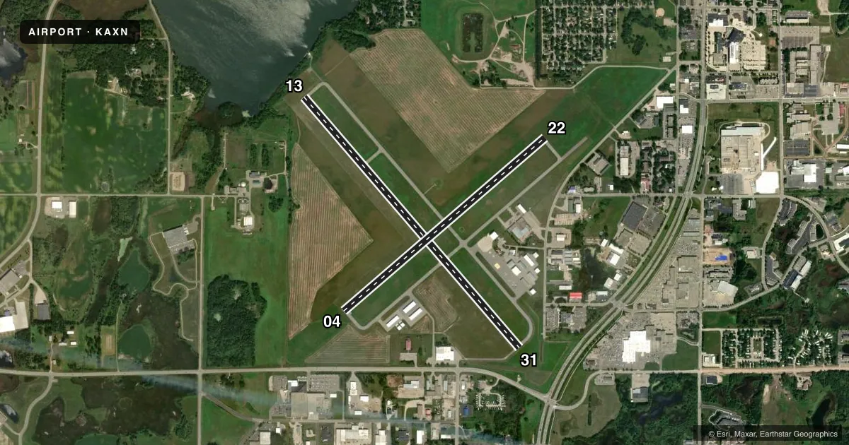
Airport sketch
Runways drawn to scale from FAA survey coordinates, rendered over satellite imagery. Not for navigation.
Approaches & charts
ILS · 1
Services on the field
Fuel grades, oxygen, maintenance, ramp storage and lighting — as declared to the FAA by the airport operator.
Fuel & services
- Fuel
- 100LLA
- Oxygen (bottled)
- Not available
- Oxygen (bulk)
- Not available
- Airframe repair
- Major
- Power plant repair
- Major
- Other services
- AFRT,AMB,CHTR,INSTR,RNTL,SALES
Ramp & ground
- Transient storage
- Tie-down
- Hangar
- Landing fee
- No fee published
- Customs
- Not available
- Lighting schedule
- SEE RMK
- Beacon schedule
- SS-SR
- Beacon
- White / Green (civil land)(WG)
- Wind indicator
- Lighted
- Segmented circle
- Yes
Fuel & FBOs
Cheapest 100LL and Jet A on the field and nearby. Always confirm with the FBO before taxi.
Airport notes
Surface conditions, obstructions, local procedures, lighting outages and other notes published with each FAA cycle.
General notes
- WATERFOWL & JACKRABBITS ON & INVOF RY.
- ULTRALIGHT TRAFFIC ON & INVOF ARPT.
- YELLOW BOX ON RAMP RESD FOR MED HEL - BEWARE OF ROTOR BLAST AT TIEDOWNS.
- FOR CD IF UNA TO CTC ON FSS FREQ, CTC MINNEAPOLIS ARTCC AT 651-463-5588.
Lighting notes
- MIRL RY 13/31 PRESET ON LOW INTST; TO INCR INTST & ACTVT REIL RY 04/22; PAPI RY 04/22; MIRL RY 04/22; ODALS RY31; REIL RY 13; PAPI RY 13/31; MIRL RY 13/31 - CTAF.
Fuel notes
- AFOR FUEL SVC AFT HRS, CTC 320-760-7175.
Approach & departure obstructions
- 31RWY 31 HAS A ROAD IN PRIM SFC 55 FT FM THE RWY END AND 469 FT R
VFR map & nearby airports
VFR sectional. Tap any ICAO chip to open that airport.
Key facts · KAXN
Answer card- ICAO
- KAXN
- Name
- ALEXANDRIA RGNL/CHANDLER FLD
- Location
- ALEXANDRIA, MINNESOTA
- Elevation
- 1,425.3 ft MSL
- Traffic pattern altitude
- 2,425.3 ft MSL (1,000 AGL)
- Control tower
- Non-towered (use CTAF)
- Total runways
- 2
- Longest runway
- 13/31 · 5,099 ft
- Published ILS approaches
- 1
- Published frequencies
- 2
- Magnetic variation
- 4°
- Current flight rules
- VFR
- Current wind
- 300° at 7 kt
- Favored runway now
- RWY 31
KAXN is in Alexandria, Minnesota. The field elevation is 1,425.3 ft MSL. It has 2 asphalt runways. The longest is Runway 13/31 at 5,099 ft. There is no control tower. CTAF and UNICOM are both 123.0. One ILS approach is published for Runway 31.
Pattern altitude is not published. Use the standard 1,000 ft AGL for light piston operations unless local procedures or ATC say otherwise. Alexandria Aviation is on the field. It carries 100LL and Jet A. Call (320) 762-2111 for current service details.
A few remarks matter here. Runway 31 has a road in the primary surface near the departure end. Ultralight traffic is on and in the vicinity of the airport. A yellow box on the ramp is reserved for the medical helicopter. Watch for rotor blast near tiedowns. Waterfowl and jackrabbits are also reported near the runways. The runway lights and approach lighting are activated or brightened by keying the CTAF, so brief your lighting plan before night or low-vis arrivals. For clearance delivery, if Flight Service is not available, Minneapolis ARTCC can be reached at 651-463-5588.