METAR & TAF 05Y
05Y does not publish a METAR.
Showing the nearest reporting station: KADC (WADENA MUNI) · 12.9 NM away. Conditions at 05Y may differ.
METAR · KADC
Observed 06:36Z
KADC 270636Z AUTO 24007KT 10SM CLR 27/24 A2972 RMK AO2
- Wind
- 240° @ 7 kt
- Visibility
- 10 SM
- Temp / Dew
- 27°C / 24°C
- Altimeter
- 29.72 inHg
- Clouds
- CLR
- Density alt
- 3,492 ft
- Ceiling
- Unlimited
- Rules
- VFR
Airport info & contacts
Manager on record, flight service, ARTCC, attendance schedule and pattern altitude — published by the FAA and refreshed every 28 days.
Location
- From city
- 1 NM S
- VFR sectional
- TWIN CITIES
- ARTCC
- ZMP · MINNEAPOLIS
- NOTAM facility
- PNM (NOTAM-D)
Airport manager
- Name
- TED STRAND
- Phone
- 218-583-2402
- Address
- 612 FRONT ST, PO BOX 55, HENNING MN 56551
Flight service · Hours
- FSS PNM
- PRINCETON1-800-WX-BRIEF
- Attendance
- Unattended
Frequencies
Tap any row to copy the frequency to your clipboard.
Runways & pattern
Full pagePattern entry · RWY 17
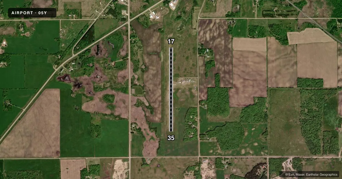
LEFT TRAFFICAirport sketch
Runways drawn to scale from FAA survey coordinates, rendered over satellite imagery. Not for navigation.
Approaches & charts
Services on the field
Fuel grades, oxygen, maintenance, ramp storage and lighting — as declared to the FAA by the airport operator.
Fuel & services
- Fuel
- 100LL
- Oxygen (bottled)
- Not available
- Oxygen (bulk)
- Not available
- Airframe repair
- Not available
- Power plant repair
- Not available
- Other services
- INSTR,RNTL
Ramp & ground
- Transient storage
- Tie-down
- Landing fee
- No fee published
- Customs
- Not available
- Lighting schedule
- SS-SR
- Beacon schedule
- SS-SR
- Beacon
- White / Green (civil land)(WG)
- Wind indicator
- Lighted
- Segmented circle
- No
Fuel & FBOs
Cheapest 100LL and Jet A on the field and nearby. Always confirm with the FBO before taxi.
Airport notes
Surface conditions, obstructions, local procedures, lighting outages and other notes published with each FAA cycle.
General notes
- FOR CD CTC MINNEAPOLIS ARTCC AT 651-463-5588.
Fuel notes
- 100LLFUEL AVBL 24 HRS WITH CREDIT CARD.
Approach & departure obstructions
- 17MKD WITH YELLOW CONES.
- 35MKD WITH YELLOW CONES.
Other notes
- ESTABD BFR 1959.
- 17/35LRG RUTS/HOLES ON TURF RWY.
VFR map & nearby airports
VFR sectional. Tap any ICAO chip to open that airport.
Key facts · 05Y
Answer card- ICAO
- 05Y
- Name
- HENNING MUNI
- Location
- HENNING, MINNESOTA
- Elevation
- 1,455 ft MSL
- Traffic pattern altitude
- 2,455 ft MSL (1,000 AGL)
- Control tower
- Non-towered (use CTAF)
- Total runways
- 1
- Longest runway
- 17/35 · 3,199 ft
- Published ILS approaches
- 0
- Published frequencies
- 1
- Magnetic variation
- 5°
- Current flight rules
- VFR
- Current wind
- 240° at 7 kt
- Favored runway now
- RWY 17
Henning Muni sits in Henning, Minnesota. Field elevation is 1,455 ft MSL. The airport has one runway. Runway 17/35 is 3,199 ft of turf. The field is not towered. CTAF is 122.9. No ILS approaches are published.
Pattern altitude is not published. Use the standard 1,000 ft AGL pattern unless the current Chart Supplement says otherwise. The airport is a simple turf strip, but the published remarks matter here. Runway 17 and Runway 35 are marked with yellow cones. The turf also has large ruts and holes. That is worth a careful walk or a slow taxi before you commit to landing.
Henning Municipal Airport is the on-field FBO. It carries 100LL. Fuel is available 24 hours with credit card. If you need clearance delivery, Minneapolis ARTCC is listed in the remarks. This is a low-complexity airport, but the turf surface and the published runway condition notes make it one to respect. Check the current FAA Chart Supplement before departure for any updates on pattern work, runway condition, or local procedures.