METAR & TAF 16D
16D does not publish a METAR.
Showing the nearest reporting station: KDTL (DETROIT LAKES/WETHING FLD) · 17.1 NM away. Conditions at 16D may differ.
METAR · KDTL
Observed 13:35Z
KDTL 271335Z AUTO 33006KT 10SM OVC005 21/21 A2978 RMK AO2 T02150215
- Wind
- 330° @ 6 kt
- Visibility
- 10 SM
- Temp / Dew
- 21°C / 21°C
- Altimeter
- 29.78 inHg
- Clouds
- OVC
- Density alt
- 2,600 ft
- Ceiling
- 500 ft AGL
- Rules
- IFR
Airport info & contacts
Manager on record, flight service, ARTCC, attendance schedule and pattern altitude — published by the FAA and refreshed every 28 days.
Location
- From city
- 2 NM NW
- VFR sectional
- TWIN CITIES
- ARTCC
- ZMP · MINNEAPOLIS
- NOTAM facility
- PNM (NOTAM-D)
Airport manager
- Name
- JOHNATHAN SMITH
- Phone
- (218) 346-4455
- Address
- 125 2ND ST NE,, P.O. BOX 130, PERHAM MN 56573
Flight service · Hours
- FSS PNM
- PRINCETON1-800-WX-BRIEF
- Attendance
- Unattended
Frequencies
Tap any row to copy the frequency to your clipboard.
Runways & pattern
Full pagePattern entry · RWY 31
LEFT TRAFFICRunway end performance
| End | TORA | TODA | ASDA | LDA | VGSI | Approach lights | Obstruction |
|---|---|---|---|---|---|---|---|
| 13 | — | — | — | — | PAPI 4-box left(3°) | — | — |
| 31 | — | — | — | — | PAPI 4-box left(3°) | — | — |
Declared distances in feet. TORA = takeoff run available, TODA = takeoff distance, ASDA = accelerate-stop, LDA = landing distance.
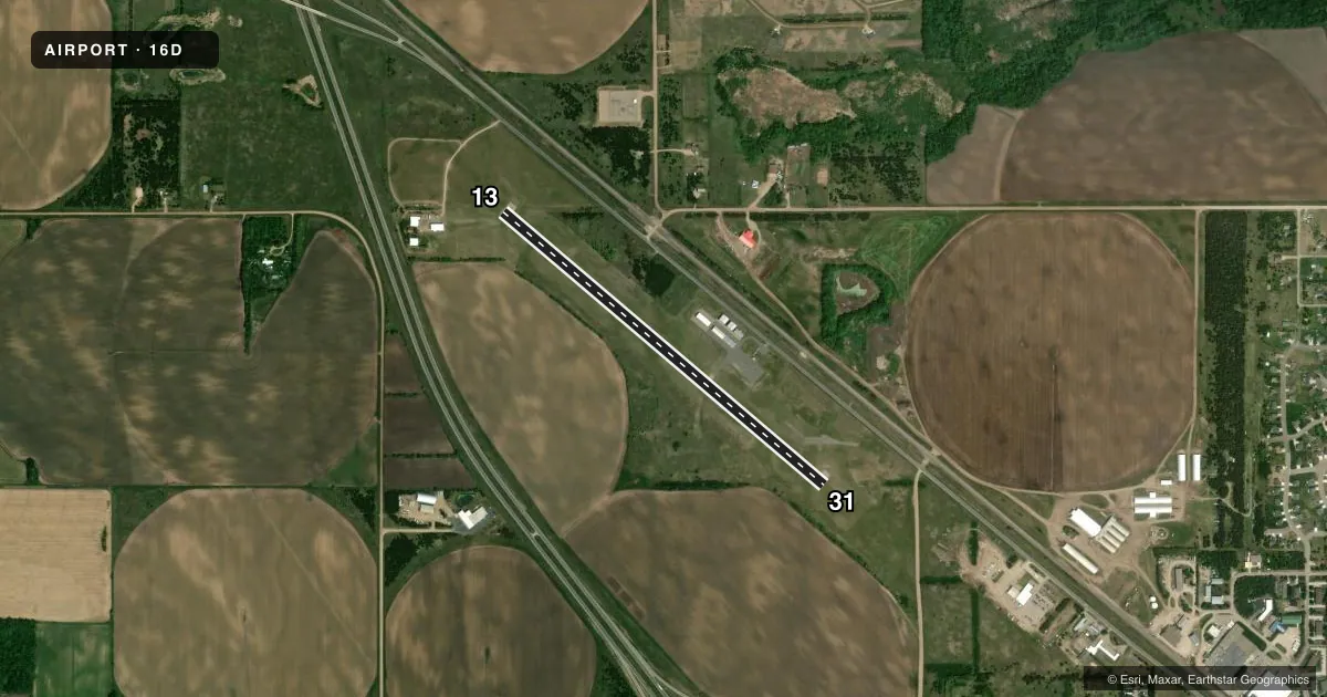
Airport sketch
Runways drawn to scale from FAA survey coordinates, rendered over satellite imagery. Not for navigation.
Approaches & charts
Services on the field
Fuel grades, oxygen, maintenance, ramp storage and lighting — as declared to the FAA by the airport operator.
Fuel & services
- Fuel
- 100LL
- Oxygen (bottled)
- Not available
- Oxygen (bulk)
- Not available
- Airframe repair
- Not available
- Power plant repair
- Not available
- Other services
- AGRI,SALES
Ramp & ground
- Transient storage
- Tie-down
- Hangar
- Landing fee
- No fee published
- Customs
- Not available
- Lighting schedule
- SEE RMK
- Beacon schedule
- SS-SR
- Beacon
- White / Green (civil land)(WG)
- Wind indicator
- Lighted
- Segmented circle
- No
Fuel & FBOs
Cheapest 100LL and Jet A on the field and nearby. Always confirm with the FBO before taxi.
Airport notes
Surface conditions, obstructions, local procedures, lighting outages and other notes published with each FAA cycle.
General notes
- ULTRALIGHTS ON & INVOF ARPT.
- HEL OPS, NW CORNER OF ARPT.
- GCO AVBL ON FREQ 121.725.
- FOR CD IF UNA VIA GCO CTC MINNEAPOLIS ARTCC AT 651-463-5588.
Lighting notes
- MIRL RY 13/31 PRESET TO LOW INTENSITY; TO INCREASE INTENSITY AND ACTVT PAPI RY 13 & RY 31 AND REIL RY 13 & RY 31 - CTAF.
Fuel notes
- 100LLFUEL AVAIL 24 HRS W CREDIT CARD.
VFR map & nearby airports
VFR sectional. Tap any ICAO chip to open that airport.
Key facts · 16D
Answer card- ICAO
- 16D
- Name
- PERHAM MUNI
- Location
- PERHAM, MINNESOTA
- Elevation
- 1,376 ft MSL
- Traffic pattern altitude
- 2,376 ft MSL (1,000 AGL)
- Control tower
- Non-towered (use CTAF)
- Total runways
- 1
- Longest runway
- 13/31 · 4,102 ft
- Published ILS approaches
- 0
- Published frequencies
- 1
- Magnetic variation
- 2°
- Current flight rules
- IFR
- Current wind
- 330° at 6 kt
- Favored runway now
- RWY 31
Perham Muni sits in Perham, Minnesota. Field elevation is 1,376 ft MSL. The airport has one runway. Runway 13/31 is 4,102 ft long with asphalt pavement. There is no control tower. CTAF is 122.9. No ILS approaches are published here.
The pattern altitude is not published. Use the standard 1,000 ft AGL pattern unless the current Chart Supplement says otherwise. The published remarks also note medium intensity runway lights on 13/31. They are preset to low intensity. Use the CTAF to increase intensity and to activate the PAPI on runway 13 and runway 31. Runway end identifier lights on both ends are also tied to CTAF activation. Fuel is available 24 hours with credit card. The on-field FBO is Perham Municipal Airport. It carries AVGAS 100LL. Call (218) 346-4455 if you need current details before arrival.
A few operational notes matter here. Helicopter operations are on the northwest corner of the airport. Ultralights are on and near the field. There is also a ground communications outlet on 121.725. If you need clearance delivery and ground comms are not available, contact Minneapolis ARTCC at 651-463-5588. For a first-time arrival, plan for an uncontrolled field with mixed traffic and use standard self-announced procedures.