METAR & TAF 47Y
47Y does not publish a METAR.
Showing the nearest reporting station: KDTL (DETROIT LAKES/WETHING FLD) · 14.2 NM away. Conditions at 47Y may differ.
METAR · KDTL
Observed 23:55Z
KDTL 272355Z AUTO 33007KT 10SM FEW060 31/22 A2980 RMK AO2 T03070224 10322 20289 50002
- Wind
- 330° @ 7 kt
- Visibility
- 10 SM
- Temp / Dew
- 31°C / 22°C
- Altimeter
- 29.80 inHg
- Clouds
- FEW
- Density alt
- 3,791 ft
- Ceiling
- Unlimited
- Rules
- VFR
Airport info & contacts
Manager on record, flight service, ARTCC, attendance schedule and pattern altitude — published by the FAA and refreshed every 28 days.
Location
- From city
- 4 NM N
- VFR sectional
- TWIN CITIES
- ARTCC
- ZMP · MINNEAPOLIS
- NOTAM facility
- PNM (NOTAM-D)
Airport manager
- Name
- BRIAN OLSON
- Phone
- 218-863-6571
- Address
- 315 N BROADWAY, BOX 350, PELICAN RAPIDS MN 56572
Flight service · Hours
- FSS PNM
- PRINCETON1-800-WX-BRIEF
- Attendance
- Unattended
Frequencies
Tap any row to copy the frequency to your clipboard.
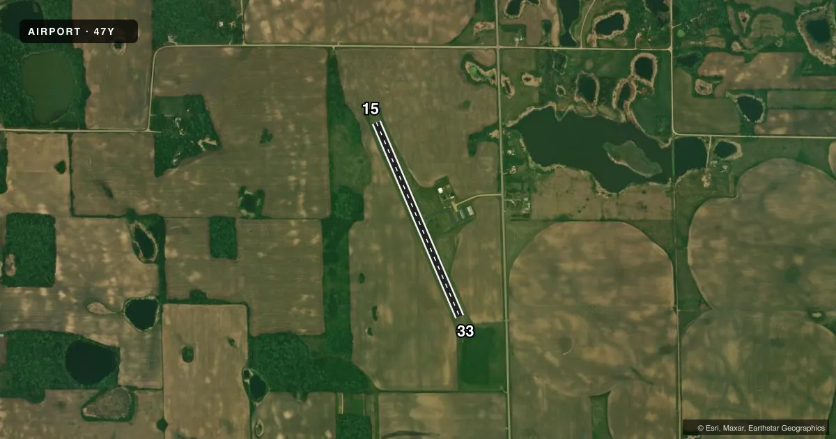
Runways & pattern
Full pagePattern entry · RWY 33
LEFT TRAFFICAirport sketch
Runways drawn to scale from FAA survey coordinates, rendered over satellite imagery. Not for navigation.
Approaches & charts
Services on the field
Fuel grades, oxygen, maintenance, ramp storage and lighting — as declared to the FAA by the airport operator.
Fuel & services
- Fuel
- Not available
Ramp & ground
- Transient storage
- Tie-down
- Landing fee
- No fee published
- Customs
- Not available
- Lighting schedule
- SS-SR
- Beacon schedule
- SS-SR
- Beacon
- White / Green (civil land)(WG)
- Wind indicator
- Lighted
- Segmented circle
- No
Fuel & FBOs
Cheapest 100LL and Jet A on the field and nearby. Always confirm with the FBO before taxi.
Airport notes
Surface conditions, obstructions, local procedures, lighting outages and other notes published with each FAA cycle.
General notes
- DEER ON & INVOF AIRPORT.
- FOR CD CTC MINNEAPOLIS ARTCC AT 651-463-5588.
- CTC 218-731-4050 FOR FUEL.
Approach & departure obstructions
- 15RWY 15 /33 MARKED WITH YELLOW CONES.
Other notes
- ADDITIONAL TIE DOWNS IN GRASS CALL APT MANAGER FOR STATUS
VFR map & nearby airports
VFR sectional. Tap any ICAO chip to open that airport.
Key facts · 47Y
Answer card- ICAO
- 47Y
- Name
- PELICAN RAPIDS MUNI-LYON'S FLD
- Location
- PELICAN RAPIDS, MINNESOTA
- Elevation
- 1,389 ft MSL
- Traffic pattern altitude
- 2,389 ft MSL (1,000 AGL)
- Control tower
- Non-towered (use CTAF)
- Total runways
- 1
- Longest runway
- 15/33 · 3,260 ft
- Published ILS approaches
- 0
- Published frequencies
- 1
- Magnetic variation
- 5°
- Current flight rules
- VFR
- Current wind
- 330° at 7 kt
- Favored runway now
- RWY 33
Pelican Rapids Muni-Lyon's Fld (47Y) sits in Pelican Rapids, Minnesota. Field elevation is 1,389 ft MSL. The airport has one runway. Runway 15/33 is 3,260 ft long and turf. The longest runway is 3,260 ft. This is an untowered field, so expect self-announce traffic on CTAF 122.9. No ILS approaches are published here.
Pattern altitude is not published. Use the standard 1,000 ft AGL pattern unless the current FAA Chart Supplement says otherwise. Deer are reported on and near the airport. Keep a sharp scan on taxi, takeoff and final. Runways 15 and 33 are marked with yellow cones. The field also has additional tie-downs in the grass. Call the airport manager for current status before you count on them.
Pelican Rapids Municipal Airport is the on-field FBO. It carries AVGAS 100LL. For fuel, the published contact is 218-731-4050. For clearance delivery, contact Minneapolis ARTCC at 651-463-5588. With a turf runway, check surface condition before you go. That matters here, especially after rain or when the grass is soft.