METAR & TAF KBWP
Current METAR
Observed 21:55Z
KBWP 272155Z AUTO VRB05KT 10SM CLR 32/22 A2979 RMK AO2
- Wind
- VAR @ 5 kt
- Visibility
- 10 SM
- Temp / Dew
- 32°C / 22°C
- Altimeter
- 29.79 inHg
- Clouds
- CLR
- Density alt
- 3,402 ft
- Ceiling
- Unlimited
- Rules
- VFR
Airport info & contacts
Manager on record, flight service, ARTCC, attendance schedule and pattern altitude — published by the FAA and refreshed every 28 days.
Location
- From city
- 1 NM S
- VFR sectional
- TWIN CITIES
- ARTCC
- ZMP · MINNEAPOLIS
- NOTAM facility
- GFK (NOTAM-D)
Airport manager
- Name
- JON KLEIN
- Phone
- 701-642-5777
- Address
- 1251 PEGASUS ROAD, WAHPETON ND 58075
Flight service · Hours
- FSS GFK
- GRAND FORKS1-800-WX-BRIEF
- Attendance
- MON-FRI · 0800-1700
- SAT-SUN · ON CALL
Frequencies
Tap any row to copy the frequency to your clipboard.
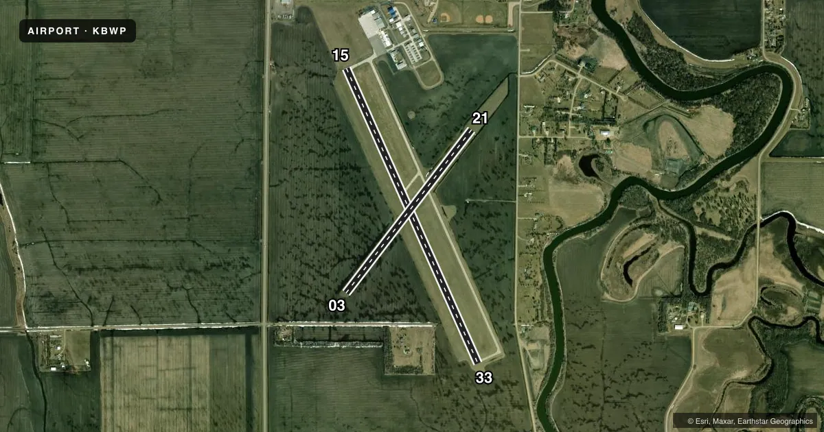
Runways & pattern
Full pagePattern entry · RWY 33
LEFT TRAFFIC| Runway | Heading (°M) | Length | Surface | Traffic |
|---|---|---|---|---|
| 15/33Favored | 151° / 331° | 5,100 ft | CONC | Standard L |
| 03/21 | 33° / 213° | 3,254 ft | TURF | Standard L |
Runway end performance
| End | TORA | TODA | ASDA | LDA | VGSI | Approach lights | Obstruction |
|---|---|---|---|---|---|---|---|
| 15 | — | — | — | — | PAPI 2-box left(3°) | — | 45', trees, 1400' from thr, 80' R of cntrln, slope 26 |
| 33 | — | — | — | — | PAPI 2-box left(3°) | — | 42', trees, 1410' from thr, 130' R of cntrln, slope 28 |
| 03 | — | — | — | — | — | — | 49', trees, 886' from thr, 138' R of cntrln, slope 18 |
Declared distances in feet. TORA = takeoff run available, TODA = takeoff distance, ASDA = accelerate-stop, LDA = landing distance.
Airport sketch
Runways drawn to scale from FAA survey coordinates, rendered over satellite imagery. Not for navigation.
Approaches & charts
Services on the field
Fuel grades, oxygen, maintenance, ramp storage and lighting — as declared to the FAA by the airport operator.
Fuel & services
- Fuel
- 100LLA
- Oxygen (bottled)
- Not available
- Oxygen (bulk)
- Not available
- Airframe repair
- Major
- Power plant repair
- Major
- Other services
- AGRI
Ramp & ground
- Transient storage
- Tie-down
- Hangar
- Landing fee
- No fee published
- Customs
- Not available
- Lighting schedule
- SEE RMK
- Beacon schedule
- SS-SR
- Beacon
- White / Green (civil land)(WG)
- Wind indicator
- Lighted
- Segmented circle
- Yes
Fuel & FBOs
Cheapest 100LL and Jet A on the field and nearby. Always confirm with the FBO before taxi.
Airport notes
Surface conditions, obstructions, local procedures, lighting outages and other notes published with each FAA cycle.
General notes
- RY 03 SAFETY AREA CULTIVATED UNEVEN DIRT, SOFT WHEN WET.
- DEER AND BIRDS ON OR INVOF ARPT.
- FOR CD CTC MINNEAPOLIS ARTCC AT 651-463-5588.
- CFM ARPT CONDS IN WINTER MONTHS BFR USE CALL 701-642-5777.
Lighting notes
- MIRL RWY 15/33 PRESET LOW INTST TO INCR INTST & ACTVT REIL RWY 15 & 33; PAPI RWY 15 & 33 - CTAF.
Fuel notes
- 100LL100LL 24 HR SELF-SERVICE WITH CREDIT CARD.
Runway surface & condition
- 03/21RWY 03/21 CLSD WINTER MONTHS.
Approach & departure obstructions
- 03RWY 03/21 MKD WITH EDGE & CORNER DALGT METAL MKRS PAINTED ORANGE.
- 1532 FT TREES 1250 FT FROM THLD BOTH SIDES OF EXTDD CNTRLN APCH RATIO 32:1.
Other notes
- 1FOR SVC AFT HRS CALL AMGR 701-361-0230.
- MANAGERADDNL PHONE 701-361-0230 OR CITY POLICE 701-642-7777.
VFR map & nearby airports
VFR sectional. Tap any ICAO chip to open that airport.
Key facts · KBWP
Answer card- ICAO
- KBWP
- Name
- HARRY STERN
- Location
- WAHPETON, NORTH DAKOTA
- Elevation
- 968.2 ft MSL
- Traffic pattern altitude
- 1,968.2 ft MSL (1,000 AGL)
- Control tower
- Non-towered (use CTAF)
- Total runways
- 2
- Longest runway
- 15/33 · 5,100 ft
- Published ILS approaches
- 0
- Published frequencies
- 2
- Magnetic variation
- 5°
- Current flight rules
- VFR
- Current wind
- 000° at 5 kt
- Favored runway now
- RWY 33
Harry Stern Airport is in Wahpeton, North Dakota. Field elevation is 968.2 ft MSL. The airport has two runways. The longest is 15/33 at 5,100 ft on concrete. Runway 03/21 is 3,254 ft on turf. There is no control tower. CTAF and UNICOM are both 123.0. No ILS approaches are published here.
Pattern altitude is not published. Use 1,000 ft AGL for light piston traffic unless the current Chart Supplement says otherwise. TriState Aviation is on the field. It carries 100LL and Jet A. 100LL is available 24 hours self-service with credit card. Runway 03/21 is closed during winter months. Runway 03 has a soft safety area when wet. Runway 15/33 has medium intensity lights that start at low intensity. You can raise the intensity and turn on runway end identifier lights by keying the common traffic advisory frequency.
Watch for deer and birds in the area. There are also 32 ft trees 1,250 ft from the threshold on both sides of the extended centerline for runway 15. If you need after-hours help, call the airport manager. For clearance delivery, contact Minneapolis ARTCC. Check winter conditions before you launch.