METAR & TAF K74
K74 does not publish a METAR.
Showing the nearest reporting station: KJKJ (MOORHEAD MUNI/FLORENCE KLINGENSMITH FLD) · 17.9 NM away. Conditions at K74 may differ.
METAR · KJKJ
Observed 21:35Z
KJKJ 272135Z AUTO 36006KT 10SM SCT050 33/22 A2979 RMK AO2
- Wind
- 360° @ 6 kt
- Visibility
- 10 SM
- Temp / Dew
- 33°C / 22°C
- Altimeter
- 29.79 inHg
- Clouds
- SCT
- Density alt
- 3,496 ft
- Ceiling
- Unlimited
- Rules
- VFR
Airport info & contacts
Manager on record, flight service, ARTCC, attendance schedule and pattern altitude — published by the FAA and refreshed every 28 days.
Location
- From city
- 1 NM E
- VFR sectional
- TWIN CITIES
- ARTCC
- ZMP · MINNEAPOLIS
- NOTAM facility
- GFK (NOTAM-D)
Airport manager
- Name
- CASEY ODEGAARD
- Phone
- 701-367-6710
- Address
- 111 1ST AVE N, KINDRED ND 58051
Flight service · Hours
- FSS GFK
- GRAND FORKS1-800-WX-BRIEF
- Attendance
- MON-FRI · 0800-1730
Frequencies
Tap any row to copy the frequency to your clipboard.
Runways & pattern
Full pagePattern entry · RWY 29
LEFT TRAFFICRunway end performance
| End | TORA | TODA | ASDA | LDA | VGSI | Approach lights | Obstruction |
|---|---|---|---|---|---|---|---|
| 11 | — | — | — | — | PAPI 2-box left(3°) | — | — |
| 29 | — | — | — | — | PAPI 2-box left(3°) | — | — |
Declared distances in feet. TORA = takeoff run available, TODA = takeoff distance, ASDA = accelerate-stop, LDA = landing distance.
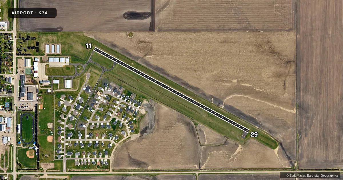
Airport sketch
Runways drawn to scale from FAA survey coordinates, rendered over satellite imagery. Not for navigation.
Approaches & charts
Services on the field
Fuel grades, oxygen, maintenance, ramp storage and lighting — as declared to the FAA by the airport operator.
Fuel & services
- Fuel
- 100LL
- Oxygen (bottled)
- Not available
- Oxygen (bulk)
- Not available
- Airframe repair
- Major
- Power plant repair
- Major
- Other services
- AGRI,INSTR,SALES
Ramp & ground
- Transient storage
- Tie-down
- Hangar
- Landing fee
- No fee published
- Lighting schedule
- SEE RMK
- Wind indicator
- Lighted
- Segmented circle
- Yes
Fuel & FBOs
Cheapest 100LL and Jet A on the field and nearby. Always confirm with the FBO before taxi.
Airport notes
Surface conditions, obstructions, local procedures, lighting outages and other notes published with each FAA cycle.
General notes
- BIRDS & DEER ON OR INVOF ARPT.
- RWY 11/29 CONFIRM WITH AMGR FOR SNOW REMOVAL PRIOR TO USE AFT WINTER STORMS.
- FOR CD CTC FARGO APCH AT 701-239-5188.
Lighting notes
- DUSK-2330; RWY 11/29 ACTVT CTAF 122.9 FOR MIRL AND PAPI AFTER 2330 HOUR.
Fuel notes
- 100LLSELF SVC FUEL AVBL 24 HRS WITH CREDIT CARD.
Approach & departure obstructions
- 11320' LIGHTED TOWER 4100' FM THLD; 2700' R OF EXTDD CNTRLN
Other notes
- AIRCRAFT REPAIR SHOP CTC ODEGAARD WINGS AT 701-428-3457.
- 1FOR SVC AFT HRS CALL (701) 367-6710.
- MANAGERADL CTC KELLY PERHUS (CHAIRMAN): 701-238-2305.
VFR map & nearby airports
VFR sectional. Tap any ICAO chip to open that airport.
Key facts · K74
Answer card- ICAO
- K74
- Name
- ROBERT ODEGAARD FLD
- Location
- KINDRED, NORTH DAKOTA
- Elevation
- 947.3 ft MSL
- Traffic pattern altitude
- 1,947.3 ft MSL (1,000 AGL)
- Control tower
- Non-towered (use CTAF)
- Total runways
- 1
- Longest runway
- 11/29 · 3,300 ft
- Published ILS approaches
- 0
- Published frequencies
- 3
- Magnetic variation
- 4°
- Current flight rules
- VFR
- Current wind
- 360° at 6 kt
- Favored runway now
- RWY 29
Robert Odegaard Fld sits in Kindred, North Dakota. The field elevation is 947.3 ft MSL. It has one runway, 11/29, which is 3,300 ft long and paved concrete. There is no control tower. CTAF is 122.9. Fargo Approach handles clearance delivery and approach or departure services on 120.4 and 377.15. No ILS approaches are published here.
The published pattern altitude is not given, so use the standard 1,000 ft AGL for light piston operations unless the current FAA Chart Supplement says otherwise. That puts the pattern at about 1,947 ft MSL based on the field elevation. The airport remarks also call out birds and deer in the area. There is a lighted tower 4,100 ft from the threshold of runway 11 and 2,700 ft right of the extended centerline. That matters on the 11 arrival path.
Robert Odegaard Field is the on-field FBO. It carries self-serve 100LL. Fuel is available 24 hours with a credit card. For aircraft repair, Odegaard Wings is listed on the field. After winter storms, confirm snow removal with the airport manager before using runway 11/29. If you need administrative help, the published contacts are in the current FAA Chart Supplement.