METAR & TAF 4R6
4R6 does not publish a METAR.
Showing the nearest reporting station: KGWR (GWINNER/ROGER MELROE FLD) · 8.9 NM away. Conditions at 4R6 may differ.
METAR · KGWR
Observed 15:15Z
KGWR 271515Z AUTO 32015KT 7SM CLR 26/24 A2984 RMK A01
- Wind
- 320° @ 15 kt
- Visibility
- 7 SM
- Temp / Dew
- 26°C / 24°C
- Altimeter
- 29.84 inHg
- Clouds
- CLR
- Density alt
- 2,772 ft
- Ceiling
- Unlimited
- Rules
- VFR
Airport info & contacts
Manager on record, flight service, ARTCC, attendance schedule and pattern altitude — published by the FAA and refreshed every 28 days.
Location
- From city
- 1 NM E
- VFR sectional
- TWIN CITIES
- ARTCC
- ZMP · MINNEAPOLIS
- NOTAM facility
- GFK (NOTAM-D)
Airport manager
- Name
- MARK GAINOR
- Phone
- 701-680-1001
- Address
- 7950 141 AVE SE, MILNOR ND 58060
Flight service · Hours
- FSS GFK
- GRAND FORKS1-800-WX-BRIEF
- Attendance
- Unattended
Frequencies
Tap any row to copy the frequency to your clipboard.
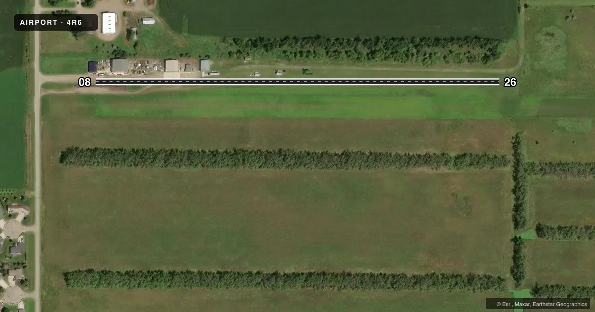
Runways & pattern
Full pagePattern entry · RWY 26
LEFT TRAFFICRunway end performance
| End | TORA | TODA | ASDA | LDA | VGSI | Approach lights | Obstruction |
|---|---|---|---|---|---|---|---|
| 08 | — | — | — | — | — | — | 10', road, 0' from thr, 60' R of cntrln, slope 1 |
Declared distances in feet. TORA = takeoff run available, TODA = takeoff distance, ASDA = accelerate-stop, LDA = landing distance.
Airport sketch
Runways drawn to scale from FAA survey coordinates, rendered over satellite imagery. Not for navigation.
Approaches & charts
Services on the field
Fuel grades, oxygen, maintenance, ramp storage and lighting — as declared to the FAA by the airport operator.
Fuel & services
- Fuel
- Not available
- Airframe repair
- Not available
- Power plant repair
- Not available
- Other services
- AGRI
Ramp & ground
- Transient storage
- Tie-down
- Hangar
- Landing fee
- No fee published
- Customs
- Not available
- Wind indicator
- Yes
- Segmented circle
- No
Fuel & FBOs
Cheapest 100LL and Jet A on the field and nearby. Always confirm with the FBO before taxi.
Airport notes
Surface conditions, obstructions, local procedures, lighting outages and other notes published with each FAA cycle.
General notes
- CONFIRM ARPT COND PRIOR TO LANDING DUE TO IREG SNOW REMOVAL; PHONE REQUEST ONLY 701-680-1001.
- RY 08/26 HAS 250' TURF STWY WEST END.
- RY 08/26 CROSSWIND TURBULENCE DUE TO CLOSE PROXIMITY TREE GROWTH. ADDITIONALLY, TREES TO N AND S, WINDSOCKS AND BUILDINGS TO THE N RY PENETRATE 7:1 TRANSITIONAL SURFACE.
- RY 08 +18 FT RD 300 FT FM THLD ON CNTRLN, APCH RATIO 17:1 AND TREES 1000' FM THLD OFFSET 160' R OF CNTRLN, APCH RATIO 16:1.
- RY 08 HAS 215+ FT GRAIN ELEV 3600' FT FM THLD, OFFSET 240' R OF CNTRLN, APCH RATIO 16:1.
- DEER & BIRDS ON OR INVOF OF ARPT.
- FOR CD CTC MINNEAPOLIS ARTCC AT 651-463-5588.
Other notes
- EXISTED PRIOR TO 1959.
- MANAGERADDL PHONE PAUL ELLEFSON AUTH MEMBER: 701-680-1966.
VFR map & nearby airports
VFR sectional. Tap any ICAO chip to open that airport.
Key facts · 4R6
Answer card- ICAO
- 4R6
- Name
- MILNOR MUNI
- Location
- MILNOR, NORTH DAKOTA
- Elevation
- 1,091 ft MSL
- Traffic pattern altitude
- 2,091 ft MSL (1,000 AGL)
- Control tower
- Non-towered (use CTAF)
- Total runways
- 1
- Longest runway
- 08/26 · 2,210 ft
- Published ILS approaches
- 0
- Published frequencies
- 1
- Magnetic variation
- 7°
- Current flight rules
- VFR
- Current wind
- 320° at 15 kt
- Favored runway now
- RWY 26
Milnor Muni is in Milnor, North Dakota. Field elevation is 1,091 ft MSL. The airport has one runway. Runway 08/26 is 2,210 ft of turf, so plan for a short-field surface and check braking conditions before you go. There is no control tower. CTAF is 122.9. No ILS approaches are published.
The pattern altitude is not published. Use the standard 1,000 ft AGL pattern unless the current FAA Chart Supplement or local traffic calls for something different. That puts the light-aircraft pattern at about 2,091 ft MSL based on the listed field elevation. The published remarks matter here. Runway 08/26 has tree growth close to the strip. That can create crosswind turbulence. Trees, windsocks and buildings north of the runway also penetrate the transitional surface. Runway 08 has a grain elevator, a road and more trees on approach. Deer and birds are also reported in the area.
No on-field FBOs are listed. Check with the airport operator or the FBO directly by phone before arrival. For airport condition updates, the remarks list a phone request number. For clearance delivery, contact Minneapolis ARTCC. If you are planning a first stop here, treat this as a small turf field with obstacles near the approach path and verify surface condition before landing, especially after snow.