METAR & TAF 6L3
6L3 does not publish a METAR.
Showing the nearest reporting station: KGWR (GWINNER/ROGER MELROE FLD) · 14.2 NM away. Conditions at 6L3 may differ.
METAR · KGWR
Observed 18:55Z
KGWR 261855Z AUTO 12009KT 10SM SCT032 SCT060 BKN075 22/18 A2998 RMK A01
- Wind
- 120° @ 9 kt
- Visibility
- 10 SM
- Temp / Dew
- 22°C / 18°C
- Altimeter
- 29.98 inHg
- Clouds
- BKN
- Density alt
- 2,304 ft
- Ceiling
- 7,500 ft AGL
- Rules
- VFR
Airport info & contacts
Manager on record, flight service, ARTCC, attendance schedule and pattern altitude — published by the FAA and refreshed every 28 days.
Location
- From city
- 2 NM W
- VFR sectional
- TWIN CITIES
- ARTCC
- ZMP · MINNEAPOLIS
- NOTAM facility
- GFK (NOTAM-D)
Airport manager
- Name
- BEN HALSTENSON
- Phone
- 701-739-5463
- Address
- 6683 129TH AVE SE, 423 MAIN STREET, LISBON ND 58054
Flight service · Hours
- FSS GFK
- GRAND FORKS1-800-WX-BRIEF
- Attendance
- ON CALL
Frequencies
Tap any row to copy the frequency to your clipboard.
Runways & pattern
Full pagePattern entry · RWY 14
LEFT TRAFFIC| Runway | Heading (°M) | Length | Surface | Traffic |
|---|---|---|---|---|
| 14/32Favored | 146° / 326° | 3,397 ft | ASPH | Standard L |
| 03/21 | 30° / 210° | 1,320 ft | TURF | Standard L |
Runway end performance
| End | TORA | TODA | ASDA | LDA | VGSI | Approach lights | Obstruction |
|---|---|---|---|---|---|---|---|
| 14 | — | — | — | — | PAPI 2-box left(3°) | — | 6', fence, 275' from thr, 260' R of cntrln, slope 12 |
| 32 | — | — | — | — | PAPI 2-box left(3°) | — | 20', road, 590' from thr, 310' R of cntrln, slope 19 |
Declared distances in feet. TORA = takeoff run available, TODA = takeoff distance, ASDA = accelerate-stop, LDA = landing distance.
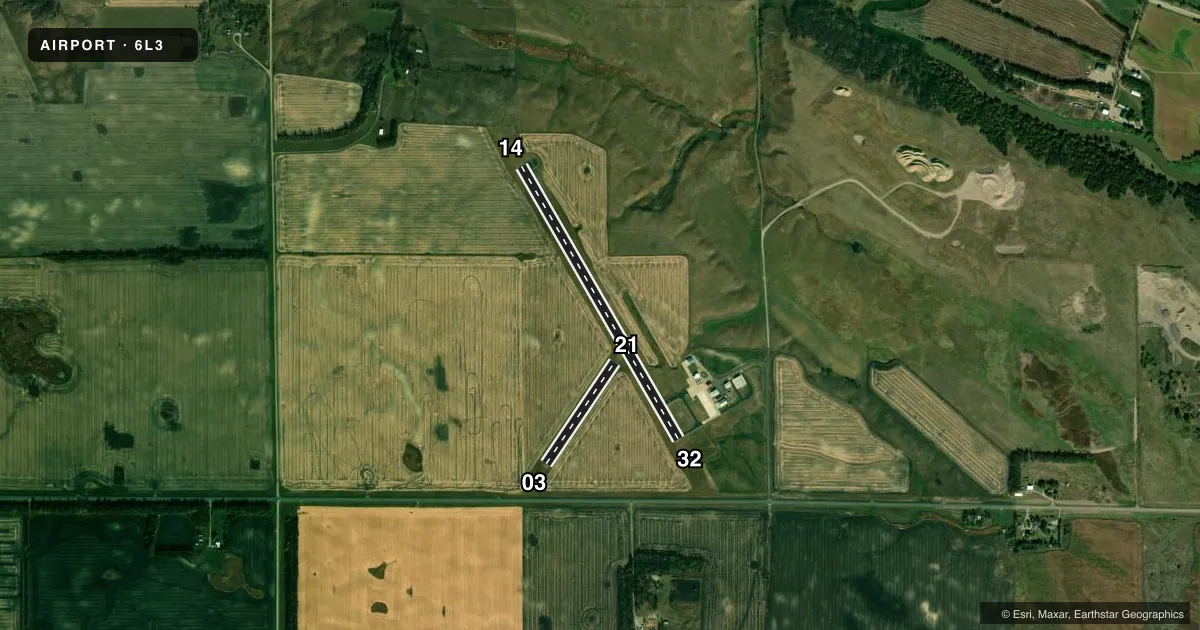
Airport sketch
Runways drawn to scale from FAA survey coordinates, rendered over satellite imagery. Not for navigation.
Approaches & charts
Services on the field
Fuel grades, oxygen, maintenance, ramp storage and lighting — as declared to the FAA by the airport operator.
Fuel & services
- Fuel
- 100LL
- Other services
- AGRI
Ramp & ground
- Transient storage
- Tie-down
- Hangar
- Landing fee
- No fee published
- Customs
- Not available
- Lighting schedule
- SEE RMK
- Beacon schedule
- SS-SR
- Beacon
- White / Green (civil land)(WG)
- Wind indicator
- Lighted
- Segmented circle
- Yes
Fuel & FBOs
Cheapest 100LL and Jet A on the field and nearby. Always confirm with the FBO before taxi.
Airport notes
Surface conditions, obstructions, local procedures, lighting outages and other notes published with each FAA cycle.
General notes
- CTC AMGR BFR USE AFT WINTER STORM DUE TO IREG SN REMOVAL; CALL 701-739-5463.
- ULTRALIGHT ACTIVITY ON OR NEAR VICINITY OF AIRPORT.
- RY 03/21 CLSD WINTER MONTHS DUE TO LACK OF SNOW REMOVAL.
- BIRDS & DEER INVOF AIRPORT.
- FOR CD CTC MINNEAPOLIS ARTCC AT 651-463-5588.
Lighting notes
- ACTVT PAPI RWY 14 & 32; MIRL RWY 14/32 - CTAF.
Fuel notes
- 100LLSELF SVC FUEL AVBL H24 VIA CREDIT CARD.
Other notes
- EXISTED PRIOR TO 1959.
- 1FOR ARPT SVCS OCT-APR CALL 701-683-5501.
- OWNERMEMBER OF ARPT AUTHORITY RICHARD KIRSCH 701-308-1349.
- OWNERCITY HALL OF LISBON.
VFR map & nearby airports
VFR sectional. Tap any ICAO chip to open that airport.
Key facts · 6L3
Answer card- ICAO
- 6L3
- Name
- LISBON MUNI
- Location
- LISBON, NORTH DAKOTA
- Elevation
- 1,240.3 ft MSL
- Traffic pattern altitude
- 2,240.3 ft MSL (1,000 AGL)
- Control tower
- Non-towered (use CTAF)
- Total runways
- 2
- Longest runway
- 14/32 · 3,397 ft
- Published ILS approaches
- 0
- Published frequencies
- 1
- Magnetic variation
- 4°
- Current flight rules
- VFR
- Current wind
- 120° at 9 kt
- Favored runway now
- RWY 14
Lisbon Muni sits in Lisbon, North Dakota. The field elevation is 1,240.3 ft MSL. It has two runways. The longest is 14/32 at 3,397 ft on asphalt. Runway 03/21 is 1,320 ft on turf. There is no control tower. CTAF is 122.9. No ILS approaches are published here.
For pattern work, the published pattern altitude is not listed. Use the standard 1,000 ft AGL pattern for light piston operations unless the current Chart Supplement says otherwise. Runway 14 and 32 have PAPI. Medium intensity runway lights are on 14 and 32. They are controlled by CTAF.
Sunrise Spray Service is on the field. It carries 100LL. Self-serve 100LL is available 24 hours a day by credit card. For airport services from October through April, call the field before you go. The airport also notes birds and deer in the area. Ultralight activity occurs on or near the airport. Runway 03/21 is closed in winter because snow removal is limited, so plan on 14/32 unless the airport says otherwise. If you need clearance delivery, contact Minneapolis ARTCC. Check the current Chart Supplement before flying in after winter storms.