METAR & TAF 4F9
4F9 does not publish a METAR.
Showing the nearest reporting station: KGWR (GWINNER/ROGER MELROE FLD) · 27.6 NM away. Conditions at 4F9 may differ.
METAR · KGWR
Observed 20:35Z
KGWR 272035Z AUTO 34007KT 8SM CLR 30/21 A2983 RMK A01
- Wind
- 340° @ 7 kt
- Visibility
- 8 SM
- Temp / Dew
- 30°C / 21°C
- Altimeter
- 29.83 inHg
- Clouds
- CLR
- Density alt
- 3,536 ft
- Ceiling
- Unlimited
- Rules
- VFR
Airport info & contacts
Manager on record, flight service, ARTCC, attendance schedule and pattern altitude — published by the FAA and refreshed every 28 days.
Location
- From city
- 1 NM SE
- VFR sectional
- TWIN CITIES
- ARTCC
- ZMP · MINNEAPOLIS
- NOTAM facility
- GFK (NOTAM-D)
Airport manager
- Name
- BLANE ROBERT
- Phone
- 701-883-5047
- Address
- 7357 COUNTY ROAD 60, LAMOURE ND 58458
Flight service · Hours
- FSS GFK
- GRAND FORKS1-800-WX-BRIEF
- Attendance
- OCT-APR · ON CALL
- MAY-SEP · ON CALL
Frequencies
Tap any row to copy the frequency to your clipboard.
Runways & pattern
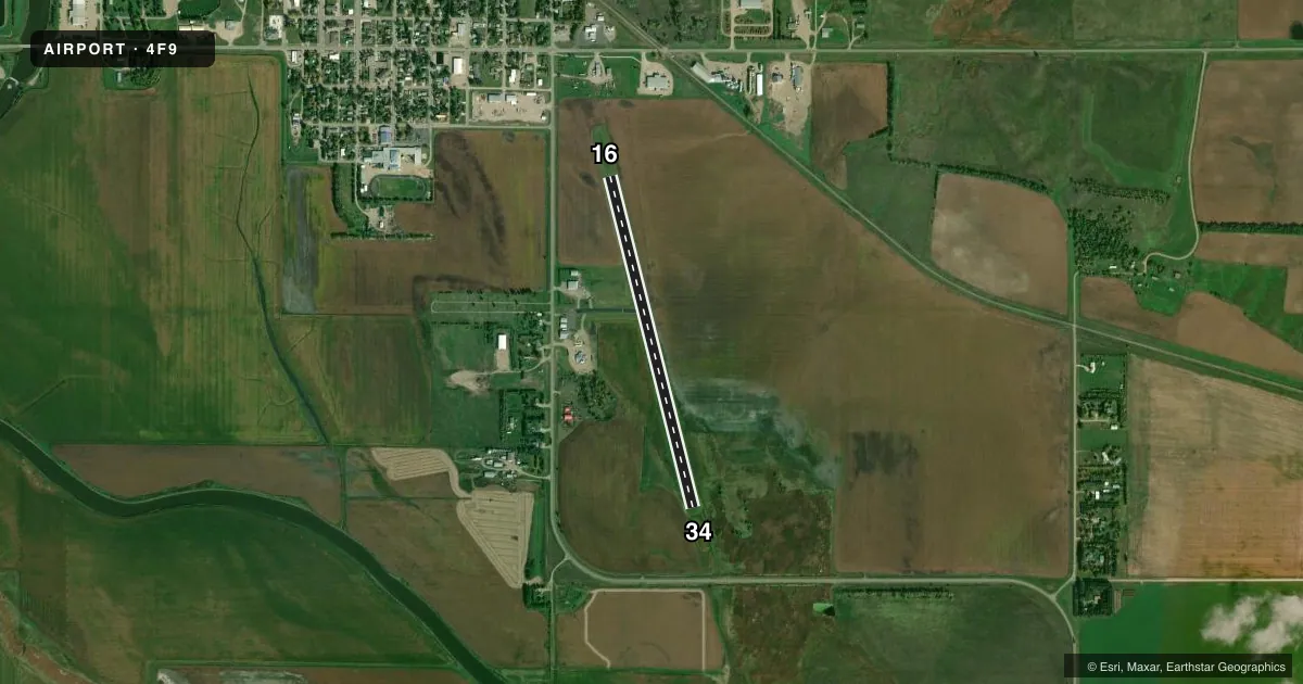
Full pagePattern entry · RWY 34
LEFT TRAFFICRunway end performance
| End | TORA | TODA | ASDA | LDA | VGSI | Approach lights | Obstruction |
|---|---|---|---|---|---|---|---|
| 16 | — | — | — | — | — | — | 14', other, 200' from thr, 120' R of cntrln, slope 0 |
Declared distances in feet. TORA = takeoff run available, TODA = takeoff distance, ASDA = accelerate-stop, LDA = landing distance.
Airport sketch
Runways drawn to scale from FAA survey coordinates, rendered over satellite imagery. Not for navigation.
Approaches & charts
Services on the field
Fuel grades, oxygen, maintenance, ramp storage and lighting — as declared to the FAA by the airport operator.
Fuel & services
- Fuel
- Not available
- Oxygen (bottled)
- Not available
- Oxygen (bulk)
- Not available
- Airframe repair
- Not available
- Power plant repair
- Not available
- Other services
- AGRI
Ramp & ground
- Transient storage
- Tie-down
- Landing fee
- No fee published
- Customs
- Not available
- Lighting schedule
- SEE RMK
- Wind indicator
- Lighted
- Segmented circle
- No
Fuel & FBOs
Cheapest 100LL and Jet A on the field and nearby. Always confirm with the FBO before taxi.
Airport notes
Surface conditions, obstructions, local procedures, lighting outages and other notes published with each FAA cycle.
General notes
- DEER & BIRDS INVOF ARPT.
- IRRIGATION SPRINKLER PIVOT SYSTEM 160 FT E CNTRLN RWY 16/34 AT 14 FT AGL VIOLATES 7:1 TRANS SFC.
- CONFIRM WINTER CONDS & SNOW REMOVAL WITH AMGR.
- FOR CD CTC MINNEAPOLIS ARTCC AT 651-463-5588.
Lighting notes
- ACTVT NSTD LIRL RWY 16/34 - CTAF.
Runway surface & condition
- 16/34NSTD LOW INTENSITY LGTS.
Approach & departure obstructions
- 1614 FT AGL MOBILE IRRIGATOR IN APCH 200 FT FM RWY THR 120 FT L.
- 1614 FT AGL MOBILE IRRIGATOR E OF RWY SWINGS INTO APCH 0:1 CLNC SLOPE.
- 1614 FT AGL MOBILE IRRIGATOR E OF RWY SWINGS INTO APCH 0:1 CLNC SLOPE.
Other notes
- MANAGERAMGR ALT CTC 701-320-4189.
VFR map & nearby airports
VFR sectional. Tap any ICAO chip to open that airport.
Key facts · 4F9
Answer card- ICAO
- 4F9
- Name
- LA MOURE ROTT MUNI
- Location
- LA MOURE, NORTH DAKOTA
- Elevation
- 1,310 ft MSL
- Traffic pattern altitude
- 2,310 ft MSL (1,000 AGL)
- Control tower
- Non-towered (use CTAF)
- Total runways
- 1
- Longest runway
- 16/34 · 3,400 ft
- Published ILS approaches
- 0
- Published frequencies
- 1
- Magnetic variation
- 7°
- Current flight rules
- VFR
- Current wind
- 340° at 7 kt
- Favored runway now
- RWY 34
La Moure Rott Muni is in La Moure, North Dakota. The field elevation is 1,310 ft MSL. It has one runway, 16/34, which is 3,400 ft long and asphalt. There is no control tower. CTAF is 122.9.
No ILS approaches are published here. The pattern altitude is not published in the facts, so use the standard 1,000 ft AGL pattern unless the current FAA Chart Supplement says otherwise. The runway has nonstandard low-intensity lights. They are activated by CTAF. Published remarks also call out deer and birds in the area. Winter conditions and snow removal should be confirmed with the airport manager before you go.
There are no on-field FBOs listed in the facts. Plan to call the airport manager or the field directly for current services before arrival. The remarks also note a mobile irrigator east of runway 16/34. It can swing into the approach near the threshold. There is also an irrigation pivot system east of the centerline that affects the transitional surface. That makes a close look at the current Chart Supplement a good idea before a first visit. For clearance delivery, Minneapolis ARTCC is listed in the remarks. The airport manager alternate contact is 701-320-4189.