METAR & TAF 2D5
Current METAR
Observed 19:55Z
K2D5 271955Z AUTO 36007G12KT CLR 31/16 A2986 RMK AO2
- Wind
- 360° @ 7G12 kt
- Visibility
- —
- Temp / Dew
- 31°C / 16°C
- Altimeter
- 29.86 inHg
- Clouds
- CLR
- Density alt
- 3,650 ft
- Ceiling
- Unlimited
- Rules
- VFR
Airport info & contacts
Manager on record, flight service, ARTCC, attendance schedule and pattern altitude — published by the FAA and refreshed every 28 days.
Location
- From city
- 2 NM N
- VFR sectional
- TWIN CITIES
- ARTCC
- ZMP · MINNEAPOLIS
- NOTAM facility
- GFK (NOTAM-D)
Airport manager
- Name
- TRAVIS MCPHERSON
- Phone
- 701-710-1220
- Address
- 8550 HWY 1, OAKES ND 58474
Flight service · Hours
- FSS GFK
- GRAND FORKS1-800-WX-BRIEF
- Attendance
- ON CALL
Frequencies
Tap any row to copy the frequency to your clipboard.
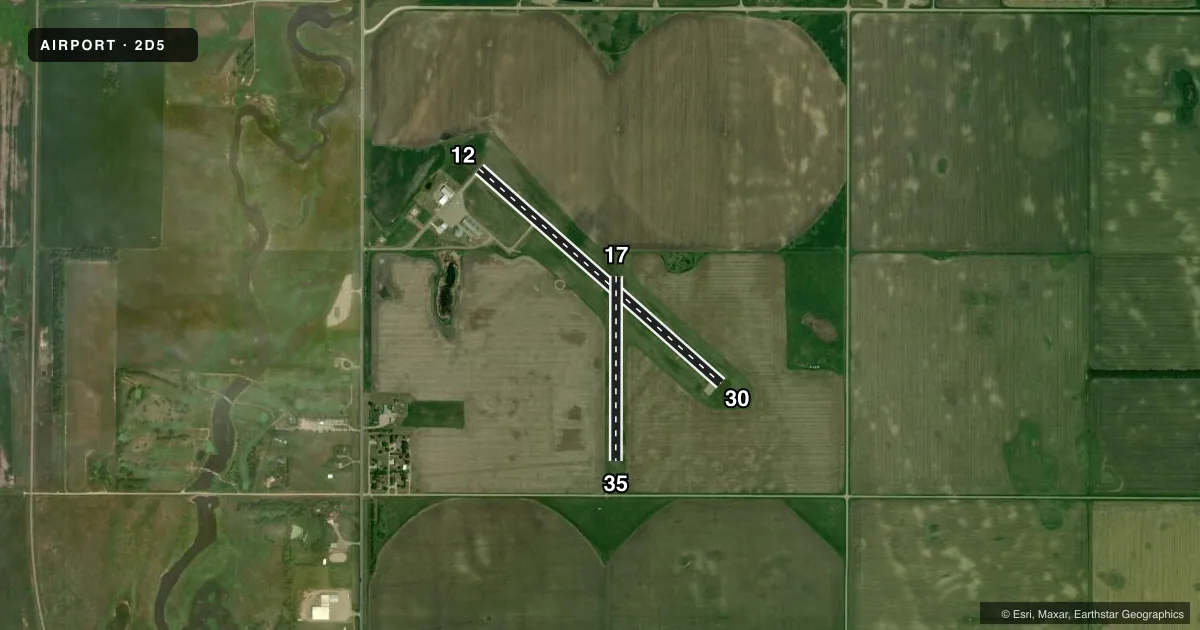
Runways & pattern
Full pagePattern entry · RWY 35
LEFT TRAFFIC| Runway | Heading (°M) | Length | Surface | Traffic |
|---|---|---|---|---|
| 12/30 | 124° / 304° | 3,505 ft | ASPH | Standard L |
| 17/35Favored | 173° / 353° | 2,001 ft | TURF | Standard L |
Runway end performance
| End | TORA | TODA | ASDA | LDA | VGSI | Approach lights | Obstruction |
|---|---|---|---|---|---|---|---|
| 12 | — | — | — | — | PAPI 2-box left(3°) | — | 14', other, 300' from thr, 265' R of cntrln, slope 7 |
| 30 | — | — | — | — | PAPI 2-box left(3°) | — | — |
Declared distances in feet. TORA = takeoff run available, TODA = takeoff distance, ASDA = accelerate-stop, LDA = landing distance.
Airport sketch
Runways drawn to scale from FAA survey coordinates, rendered over satellite imagery. Not for navigation.
Approaches & charts
Services on the field
Fuel grades, oxygen, maintenance, ramp storage and lighting — as declared to the FAA by the airport operator.
Fuel & services
- Fuel
- Not available
- Airframe repair
- Minor
- Power plant repair
- Minor
- Other services
- AGRI
Ramp & ground
- Transient storage
- Tie-down
- Hangar
- Landing fee
- No fee published
- Lighting schedule
- SEE RMK
- Beacon schedule
- SS-SR
- Beacon
- White / Green (civil land)(WG)
- Wind indicator
- Lighted
- Segmented circle
- Yes
Fuel & FBOs
Cheapest 100LL and Jet A on the field and nearby. Always confirm with the FBO before taxi.
Airport notes
Surface conditions, obstructions, local procedures, lighting outages and other notes published with each FAA cycle.
General notes
- CFM ARPT CONDS WINTER MONTHS BFR USE CALL 701-710-1220 OR 701-678-4661.
- RWY 17/35 CLSD WINTER MONTHS NO SNOW REMOVAL.
- FBO HRS MON-FRI 0800-1700 FREQ 122.9.
- FOR CD CTC MINNEAPOLIS ARTCC AT 651-463-5588.
Lighting notes
- ACTVT MIRL RY 12/30 & PAPI RYS 12 & 30 - CTAF.
Approach & departure obstructions
- 12MOBILE IRRIGATOR INTMTLY IN APCH L & R OF CNTRLN.
Other notes
- 1ON CALL AFTER HRS 701-710-1220.
- MANAGERADL CONTACT GARY SCHNELL 701-678-4910, DEAN SCHMIT 701-678-4661, SCOTT GERMAN 701-710-0624.
- OWNERARPT AUTHORITY CLERK.
VFR map & nearby airports
VFR sectional. Tap any ICAO chip to open that airport.
Key facts · 2D5
Answer card- ICAO
- 2D5
- Name
- OAKES MUNI
- Location
- OAKES, NORTH DAKOTA
- Elevation
- 1,334.9 ft MSL
- Traffic pattern altitude
- 2,334.9 ft MSL (1,000 AGL)
- Control tower
- Non-towered (use CTAF)
- Total runways
- 2
- Longest runway
- 12/30 · 3,505 ft
- Published ILS approaches
- 0
- Published frequencies
- 1
- Magnetic variation
- 7°
- Current flight rules
- VFR
- Current wind
- 360° at 7 kt
- Favored runway now
- RWY 35
Oakes Muni sits at Oakes, North Dakota. Field elevation is 1,334.9 ft MSL. The airport has two runways. The longest is runway 12/30 at 3,505 ft asphalt. Runway 17/35 is 2,001 ft turf. There is no control tower. CTAF is 122.9.
No ILS approaches are published here. Pattern altitude is not published, so use the standard 1,000 ft AGL for light piston traffic unless local procedures say otherwise. The published remarks matter here. Runway 12/30 has medium intensity runway lights. The PAPI on 12 and 30 is activated by CTAF. Runway 17/35 is closed during winter months with no snow removal. A mobile irrigator may sit intermittently left or right of centerline on runway 12. That makes a careful look at the runway before landing a good idea.
There is no on-field FBO listed in the facts. FBO options vary. Contact the airport operator directly before arrival, or call the field on CTAF/UNICOM for current FBO availability. For clearance delivery, Minneapolis ARTCC is listed in the Chart Supplement. Winter conditions can change fast here, so confirm airport status before you go.