METAR & TAF 51D
51D does not publish a METAR.
Showing the nearest reporting station: KJMS (JAMESTOWN RGNL) · 34.9 NM away. Conditions at 51D may differ.
METAR · KJMS
Observed 17:56Z
KJMS 271756Z AUTO 33011G19KT 10SM CLR 28/21 A2987 RMK AO2 SLP105 T02830206 10283 20194 58001
- Wind
- 330° @ 11G19 kt
- Visibility
- 10 SM
- Temp / Dew
- 28°C / 21°C
- Altimeter
- 29.87 inHg
- Clouds
- CLR
- Density alt
- 3,610 ft
- Ceiling
- Unlimited
- Rules
- VFR
Airport info & contacts
Manager on record, flight service, ARTCC, attendance schedule and pattern altitude — published by the FAA and refreshed every 28 days.
Location
- From city
- 1 NM WSW
- VFR sectional
- TWIN CITIES
- ARTCC
- ZMP · MINNEAPOLIS
- NOTAM facility
- GFK (NOTAM-D)
Airport manager
- Name
- DAVE LUX
- Phone
- (701) 320-8740
- Address
- PO BOX 334, BOX 345, EDGELEY ND 58433
Flight service · Hours
- FSS GFK
- GRAND FORKS1-800-WX-BRIEF
- Attendance
- Unattended
Frequencies
Tap any row to copy the frequency to your clipboard.
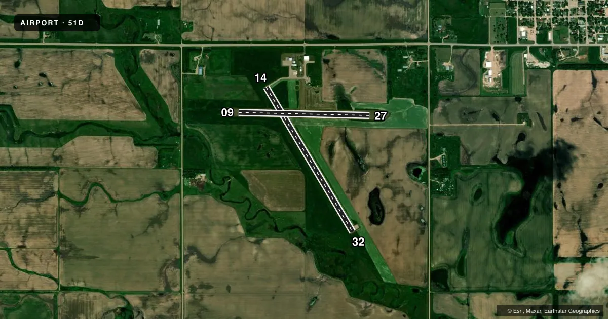
Runways & pattern
Full pagePattern entry · RWY 32
LEFT TRAFFIC| Runway | Heading (°M) | Length | Surface | Traffic |
|---|---|---|---|---|
| 14/32Favored | 144° / 324° | 3,600 ft | ASPH | Standard L |
| 09/27 | 86° / 266° | 2,800 ft | TURF | Standard L |
Runway end performance
| End | TORA | TODA | ASDA | LDA | VGSI | Approach lights | Obstruction |
|---|---|---|---|---|---|---|---|
| 14 | — | — | — | — | PAPI 2-box left(3°) | — | — |
| 32 | — | — | — | — | PAPI 2-box left(3°) | — | — |
Declared distances in feet. TORA = takeoff run available, TODA = takeoff distance, ASDA = accelerate-stop, LDA = landing distance.
Airport sketch
Runways drawn to scale from FAA survey coordinates, rendered over satellite imagery. Not for navigation.
Approaches & charts
Services on the field
Fuel grades, oxygen, maintenance, ramp storage and lighting — as declared to the FAA by the airport operator.
Fuel & services
- Fuel
- 100LLA
- Oxygen (bottled)
- Not available
- Oxygen (bulk)
- Not available
- Airframe repair
- Not available
- Power plant repair
- Not available
- Other services
- AGRI,INSTR
Ramp & ground
- Transient storage
- Tie-down
- Hangar
- Landing fee
- No fee published
- Customs
- Not available
- Lighting schedule
- SEE RMK
- Beacon schedule
- SS-SR
- Beacon
- White / Green (civil land)(WG)
- Wind indicator
- Lighted
- Segmented circle
- Yes
Fuel & FBOs
Cheapest 100LL and Jet A on the field and nearby. Always confirm with the FBO before taxi.
Airport notes
Surface conditions, obstructions, local procedures, lighting outages and other notes published with each FAA cycle.
General notes
- SNOW REMOVAL IREG; CONFIRM WINTER CONDITIONS BEFORE USE. CALL 701-709-0114/701-320-8740 FOR UPDATES.
- DEER AND BIRDS ON & INV OF ARPT.
- FOR CD CTC MINNEAPOLIS ARTCC AT 651-463-5588.
Lighting notes
- ACTVT PAPI RWY 14 & 32; MIRL RWY 14/32 - CTAF.
Fuel notes
- 100LL100LL AND JET A FUEL AVBL SELF SVC WITH CREDIT CARD.
Approach & departure obstructions
- 09RWY 27 55 FT PLINE LCTD 1205 FT FM THLD 21:1 CLNC SLOPE.
Other notes
- E111 PRVDD TFC PATS ARE DEVELOPED WHICH ARE COMPATIBLE WITH HARTING ARPT LCTD APRXLY 3.8 MILES ESE.
- MANAGERADDNL CONTACT CHAIRMAN JUSTIN FREDENBURG 701-709-0114.
VFR map & nearby airports
VFR sectional. Tap any ICAO chip to open that airport.
Key facts · 51D
Answer card- ICAO
- 51D
- Name
- EDGELEY MUNI
- Location
- EDGELEY, NORTH DAKOTA
- Elevation
- 1,603.5 ft MSL
- Traffic pattern altitude
- 2,603.5 ft MSL (1,000 AGL)
- Control tower
- Non-towered (use CTAF)
- Total runways
- 2
- Longest runway
- 14/32 · 3,600 ft
- Published ILS approaches
- 0
- Published frequencies
- 2
- Magnetic variation
- 5°
- Current flight rules
- VFR
- Current wind
- 330° at 11 kt
- Favored runway now
- RWY 32
Edgeley Muni (51D) sits in Edgeley, North Dakota. Field elevation is 1,603.5 ft MSL. The airport has two runways. The longest is runway 14/32 at 3,600 ft. Runway 09/27 is turf at 2,800 ft. There is no control tower. CTAF and UNICOM are both 122.8.
No ILS approaches are published here. Pattern altitude is not published, so use the standard 1,000 ft AGL for light piston traffic unless local procedures say otherwise. The published remarks also note that traffic patterns should be developed to stay compatible with Harting Airport about 3.8 miles east-southeast. That matters if you are planning a first arrival or a practice pattern.
The on-field FBO is Edgeley Municipal Airport. It carries 100LL and Jet A. Fuel is self-service with credit card. The remarks also say runway 32 lighting and the PAPI on runway 32 are activated by using the CTAF. Watch for a 55-foot power line near the runway 27 end. The field also notes deer and birds in the area. Snow removal is irregular, so confirm winter conditions before you go.