METAR & TAF KASY
KASY does not publish a METAR.
Showing the nearest reporting station: KABR (ABERDEEN RGNL) · 52.1 NM away. Conditions at KASY may differ.
METAR · KABR
Observed 15:53Z
KABR 271553Z AUTO 02007KT 9SM CLR 27/20 A2986 RMK AO2 SLP100 T02720200
- Wind
- 020° @ 7 kt
- Visibility
- 9 SM
- Temp / Dew
- 27°C / 20°C
- Altimeter
- 29.86 inHg
- Clouds
- CLR
- Density alt
- 4,037 ft
- Ceiling
- Unlimited
- Rules
- VFR
Airport info & contacts
Manager on record, flight service, ARTCC, attendance schedule and pattern altitude — published by the FAA and refreshed every 28 days.
Location
- From city
- 1 NM SE
- VFR sectional
- TWIN CITIES
- ARTCC
- ZMP · MINNEAPOLIS
- NOTAM facility
- GFK (NOTAM-D)
Airport manager
- Name
- LADELLE GEORGE
- Phone
- (701) 371-8707
- Address
- P.O. BOX 260, ASHLEY ND 58413
Flight service · Hours
- FSS GFK
- GRAND FORKS1-800-WX-BRIEF
- Attendance
- Unattended
Frequencies
Tap any row to copy the frequency to your clipboard.
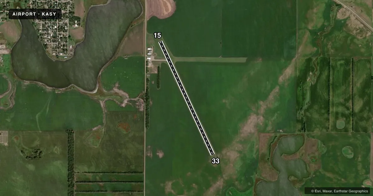
Runways & pattern
Full pagePattern entry · RWY 33
LEFT TRAFFICRunway end performance
| End | TORA | TODA | ASDA | LDA | VGSI | Approach lights | Obstruction |
|---|---|---|---|---|---|---|---|
| 15 | — | — | — | — | PAPI 2-box left(3°) | — | — |
| 33 | — | — | — | — | PAPI 2-box left(3°) | — | — |
Declared distances in feet. TORA = takeoff run available, TODA = takeoff distance, ASDA = accelerate-stop, LDA = landing distance.
Airport sketch
Runways drawn to scale from FAA survey coordinates, rendered over satellite imagery. Not for navigation.
Approaches & charts
Services on the field
Fuel grades, oxygen, maintenance, ramp storage and lighting — as declared to the FAA by the airport operator.
Fuel & services
- Fuel
- 100LL
- Oxygen (bottled)
- Not available
- Oxygen (bulk)
- Not available
- Airframe repair
- Major
- Power plant repair
- Major
- Other services
- AGRI,INSTR
Ramp & ground
- Transient storage
- Tie-down
- Hangar
- Landing fee
- No fee published
- Customs
- Not available
- Lighting schedule
- SEE RMK
- Beacon schedule
- SS-SR
- Beacon
- White / Green (civil land)(WG)
- Wind indicator
- Lighted
- Segmented circle
- Yes
Fuel & FBOs
Cheapest 100LL and Jet A on the field and nearby. Always confirm with the FBO before taxi.
Airport notes
Surface conditions, obstructions, local procedures, lighting outages and other notes published with each FAA cycle.
General notes
- WATERFOWL AND DEER ON & INVOF ARPT.
- CFM SNOW REMOVAL BFR USE. CALL 701-371-8707/701-851-0339.
- FOR CD CTC MINNEAPOLIS ARTCC AT 651-463-5588.
Lighting notes
- PAPI RWY 15 & 33, MIRL RWY 15/33 OPR CONSLY 1800-2200; AFT 2200, ACTVT - CTAF.
Fuel notes
- 100LLSELF SVC FUEL AVBL 24 HRS VIA CREDIT CARD.
VFR map & nearby airports
VFR sectional. Tap any ICAO chip to open that airport.
Key facts · KASY
Answer card- ICAO
- KASY
- Name
- ASHLEY MUNI
- Location
- ASHLEY, NORTH DAKOTA
- Elevation
- 2,034.4 ft MSL
- Traffic pattern altitude
- 3,034.4 ft MSL (1,000 AGL)
- Control tower
- Non-towered (use CTAF)
- Total runways
- 1
- Longest runway
- 15/33 · 4,364 ft
- Published ILS approaches
- 0
- Published frequencies
- 1
- Magnetic variation
- 4°
- Current flight rules
- VFR
- Current wind
- 020° at 7 kt
- Favored runway now
- RWY 33
Ashley Muni sits in Ashley, North Dakota. Field elevation is 2,034.4 ft MSL. The airport has one runway. Runway 15/33 is 4,364 ft long with asphalt pavement. There is no control tower. CTAF is 122.9. No ILS approaches are published here. Plan with the current chart and your own weather minimums in mind.
Pattern altitude is not published. Use 1,000 ft AGL as the standard light-piston pattern unless local procedures or current chart data say otherwise. The published remarks matter here. Snow removal should be confirmed before use by calling the numbers in the Chart Supplement. Deer and waterfowl are reported on and near the airport. That is worth a close scan on taxi, takeoff and landing.
Lighting is useful for night work. The PAPI and medium intensity runway lights for runways 15 and 33 operate continuously from 1800 to 2200. After 2200, activate the lights on CTAF. Self-service 100LL is available 24 hours by credit card. For clearance delivery, Minneapolis ARTCC is listed in the remarks. If you are planning a first stop here, expect a non-towered field at a higher field elevation with wildlife and winter ops to think about.