METAR & TAF 9G9
9G9 does not publish a METAR.
Showing the nearest reporting station: KJMS (JAMESTOWN RGNL) · 27.2 NM away. Conditions at 9G9 may differ.
METAR · KJMS
Observed 18:56Z
KJMS 271856Z AUTO 35010KT 10SM CLR 29/21 A2987 RMK AO2 SLP104 T02940206
- Wind
- 350° @ 10 kt
- Visibility
- 10 SM
- Temp / Dew
- 29°C / 21°C
- Altimeter
- 29.87 inHg
- Clouds
- CLR
- Density alt
- 4,103 ft
- Ceiling
- Unlimited
- Rules
- VFR
Airport info & contacts
Manager on record, flight service, ARTCC, attendance schedule and pattern altitude — published by the FAA and refreshed every 28 days.
Location
- From city
- 1 NM SW
- VFR sectional
- TWIN CITIES
- ARTCC
- ZMP · MINNEAPOLIS
- NOTAM facility
- GFK (NOTAM-D)
Airport manager
- Name
- LARRY LARSON
- Phone
- 701-485-3241
- Address
- P.O. BOX 141, GACKLE ND 58442
Flight service · Hours
- FSS GFK
- GRAND FORKS1-800-WX-BRIEF
- Attendance
- Unattended
Frequencies
Tap any row to copy the frequency to your clipboard.
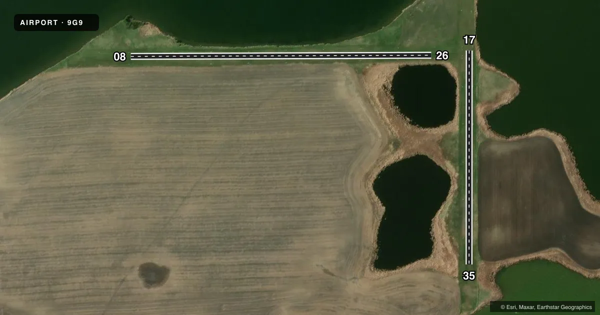
Runways & pattern
Full pagePattern entry · RWY 35
LEFT TRAFFICAirport sketch
Runways drawn to scale from FAA survey coordinates, rendered over satellite imagery. Not for navigation.
Approaches & charts
Services on the field
Fuel grades, oxygen, maintenance, ramp storage and lighting — as declared to the FAA by the airport operator.
Fuel & services
- Fuel
- Not available
- Airframe repair
- Not available
- Power plant repair
- Not available
Ramp & ground
- Transient storage
- Tie-down
- Landing fee
- No fee published
- Customs
- Not available
- Wind indicator
- Yes
- Segmented circle
- No
Fuel & FBOs
Cheapest 100LL and Jet A on the field and nearby. Always confirm with the FBO before taxi.
Airport notes
Surface conditions, obstructions, local procedures, lighting outages and other notes published with each FAA cycle.
General notes
- 5 FT HILL 60 FT R OF AER 8.
- PILOTS AT END OF RWY CANNOT SEE ACFT AT OPPOSITE END DUE TO RWY GRADIENT.
- ARPT CLSD WINTER DUE TO LACK OF SNOW REMOVAL.
- BIRDS ON & INVOF ARPT.
- BE ALERT, RY 8 FIRST 200' RISE AT 5% SLOPE.
- FOR CD CTC MINNEAPOLIS ARTCC AT 651-463-5588.
- CTN - LAKE SHORE 20 FT FM RWY 8 & 26 N EDGE NEAR RWY MIDPT.
Other notes
- MANAGERCHAIR LARRY LARSON, 701-251-8370
- 17/35RWY 08/26 TURF SFC ROLLING; GRASS CLUMPY & POSS ANIMAL HOLES.
VFR map & nearby airports
VFR sectional. Tap any ICAO chip to open that airport.
Key facts · 9G9
Answer card- ICAO
- 9G9
- Name
- GACKLE MUNI
- Location
- GACKLE, NORTH DAKOTA
- Elevation
- 1,904 ft MSL
- Traffic pattern altitude
- 2,904 ft MSL (1,000 AGL)
- Control tower
- Non-towered (use CTAF)
- Total runways
- 2
- Longest runway
- 08/26 · 1,620 ft
- Published ILS approaches
- 0
- Published frequencies
- 1
- Magnetic variation
- 8°
- Current flight rules
- VFR
- Current wind
- 350° at 10 kt
- Favored runway now
- RWY 35
Gackle Muni sits in Gackle, North Dakota. The field elevation is 1,904 ft MSL. It has two turf runways. The longest is runway 08/26 at 1,620 ft. There is no control tower. CTAF is 122.9. No ILS approaches are published.
The traffic pattern altitude is not published. Use the standard 1,000 ft AGL pattern for light piston aircraft unless the current FAA Chart Supplement says otherwise. The airport sits in open country, but the remarks matter here. Runway 08/26 has a rolling turf surface with clumpy grass and possible animal holes. The first 200 ft of runway 8 rises at a 5 percent slope. Pilots at one end cannot see traffic at the opposite end because of the runway gradient. There is also a lake shore close to the north edge near the midpoint of runway 8 and 26. Birds are reported on and near the airport. The airport is closed in winter because there is no snow removal. For clearance delivery, contact Minneapolis ARTCC. If you are planning a first stop here, treat it as a short turf field with limited visibility across the runway. Verify current conditions before departure.