METAR & TAF KJMS
Current METAR
Observed 19:56Z
KJMS 271956Z AUTO 36003KT 10SM CLR 29/20 A2986 RMK AO2 SLP101 T02940200
- Wind
- 360° @ 3 kt
- Visibility
- 10 SM
- Temp / Dew
- 29°C / 20°C
- Altimeter
- 29.86 inHg
- Clouds
- CLR
- Density alt
- 3,614 ft
- Ceiling
- Unlimited
- Rules
- VFR
Airport info & contacts
Manager on record, flight service, ARTCC, attendance schedule and pattern altitude — published by the FAA and refreshed every 28 days.
Location
- From city
- 2 NM NE
- VFR sectional
- TWIN CITIES
- ARTCC
- ZMP · MINNEAPOLIS
- NOTAM facility
- JMS (NOTAM-D)
Airport manager
- Name
- KATIE HEMMER
- Phone
- 701-252-6466
- Address
- PO BOX 1560, JAMESTOWN ND 58402
Flight service · Hours
- FSS GFK
- GRAND FORKS1-800-WX-BRIEF
- Attendance
- MON-FRI · 0800-1700
Frequencies
Tap any row to copy the frequency to your clipboard.
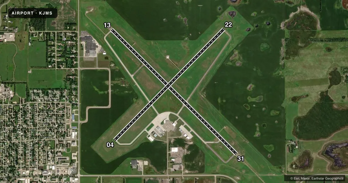
Runways & pattern
Full pagePattern entry · RWY 31
LEFT TRAFFIC| Runway | Heading (°M) | Length | Surface | Traffic |
|---|---|---|---|---|
| 13/31Favored | 131° / 311° | 6,502 ft | ASPH | Standard L |
| 04/22 | 41° / 221° | 5,750 ft | ASPH | Standard L |
Runway end performance
| End | TORA | TODA | ASDA | LDA | VGSI | Approach lights | Obstruction |
|---|---|---|---|---|---|---|---|
| 13 | 6,502' | 6,502' | 6,502' | 6,502' | PAPI 4-box left(3°) | — | 46', tree, 1927' from thr, 70' R of cntrln, slope 37 |
| 31 | 6,502' | 6,502' | 6,502' | 6,502' | PAPI 4-box left(3°) | MALSR | — |
| 04 | 5,750' | 5,750' | 5,750' | 5,750' | PAPI 4-box left(3°) | — | — |
| 22 | 5,750' | 5,750' | 5,750' | 5,750' | PAPI 4-box left(3°) | — | — |
Declared distances in feet. TORA = takeoff run available, TODA = takeoff distance, ASDA = accelerate-stop, LDA = landing distance.
Airport sketch
Runways drawn to scale from FAA survey coordinates, rendered over satellite imagery. Not for navigation.
Approaches & charts
ILS · 1
Services on the field
Fuel grades, oxygen, maintenance, ramp storage and lighting — as declared to the FAA by the airport operator.
Fuel & services
- Fuel
- 100LLA
- Oxygen (bottled)
- High pressure
- Airframe repair
- Major
- Power plant repair
- Major
- Other services
- AGRI,AMB,CHTR,INSTR,RNTL,SALES,SURV
Ramp & ground
- Transient storage
- Tie-down
- Hangar
- Landing fee
- No fee published
- Customs
- Not available
- Lighting schedule
- SEE RMK
- Beacon schedule
- SS-SR
- Beacon
- White / Green (civil land)(WG)
- Wind indicator
- Lighted
- Segmented circle
- Yes
Fuel & FBOs
Cheapest 100LL and Jet A on the field and nearby. Always confirm with the FBO before taxi.
Airport notes
Surface conditions, obstructions, local procedures, lighting outages and other notes published with each FAA cycle.
General notes
- BIRDS ON AND INVOF ARPT.
- FBO FUELING AFTER HOURS PHONE 701-952-1515.
- FOR CD IF UNA TO CTC ON FSS FREQ, CTC MINNEAPOLIS ARTCC AT 651-463-5588.
Lighting notes
- ACTVT MALSR RWY 31; REIL RWYS 04, 13, & 22; MIRL RWY 04/22; HIRL RWY 13/31 - CTAF. PAPI RWYS 04, 13, 22, & 31 OPR CONSLY.
Fuel notes
- 100LL100LL AVBL 24 HRS WITH CREDIT CARD. 24 HR PILOT LOUNGE AVBL.
Runway surface & condition
- 04/22PCR VALUE: 80/F/D/X/T
- 13/31PCR VALUE: 490/F/C/X/T
Other notes
- THIS AIRPORT HAS BEEN SURVEYED BY THE NATIONAL GEODETIC SURVEY.
- 48 HRS PPR FOR UNSKED ACR OPNS WITH MORE THAN 30 PSGR SEATS CALL AMGR 701-252-6466. ACR OPS INVOLVING ACFT WITH MORE THAN 9 PSGRS NOT AUZD IN EXCESS OF 15 MINS BEFORE OR AFTER SKED ARR/DEP TIMES WITHOUT PRIOR COORDINATION WITH AMGR AND CONFIRMATION THAT ARFF IS AVBL PRIOR TO LANDING OR TAKEOFF.
- INDEX B ARFF AVAILABLE, 48 HRS PPR CONTACT AIRPORT MANAGER 701-252-6466.
VFR map & nearby airports
VFR sectional. Tap any ICAO chip to open that airport.
Key facts · KJMS
Answer card- ICAO
- KJMS
- Name
- JAMESTOWN RGNL
- Location
- JAMESTOWN, NORTH DAKOTA
- Elevation
- 1,499.9 ft MSL
- Traffic pattern altitude
- 2,499.9 ft MSL (1,000 AGL)
- Control tower
- Non-towered (use CTAF)
- Total runways
- 2
- Longest runway
- 13/31 · 6,502 ft
- Published ILS approaches
- 1
- Published frequencies
- 2
- Magnetic variation
- 4°
- Current flight rules
- VFR
- Current wind
- 360° at 3 kt
- Favored runway now
- RWY 31
Jamestown Regional Airport sits in Jamestown, North Dakota. Field elevation is 1,499.9 ft MSL. The airport has two asphalt runways. The longest is 13/31 at 6,502 ft. Runway 04/22 is 5,750 ft. There is no control tower. CTAF and UNICOM are both 123.0.
One ILS approach is published for runway 31. Pattern altitude is not published, so use the standard 1,000 ft AGL for light piston traffic unless the current Chart Supplement says otherwise. First Class Aviation is on the field. It carries 100LL, Jet A and Jet A Prist. 100LL is available 24 hours with credit card. A 24-hour pilot lounge is also available. After-hours fueling from the FBO is handled by phone.
Lighting is useful to know here. The MALSR is on runway 31. REIL is available on runways 04, 13 and 22. Medium intensity runway lighting is on 04/22. High intensity runway lighting is on 13/31. All lighting is controlled by CTAF. PAPI operates continuously on all runway ends. Birds are reported on and near the airport. Keep a sharp scan on arrival and departure. The field also notes prior permission and coordination requirements for some air carrier and ARFF operations. Check the current FAA Chart Supplement or call the airport manager if your operation is anything out of the ordinary.