METAR & TAF 46D
Current METAR
Observed 21:35Z
K46D 272135Z AUTO VRB06KT 10SM CLR 31/20 A2989 RMK AO2
- Wind
- VAR @ 6 kt
- Visibility
- 10 SM
- Temp / Dew
- 31°C / 20°C
- Altimeter
- 29.89 inHg
- Clouds
- CLR
- Density alt
- 3,949 ft
- Ceiling
- Unlimited
- Rules
- VFR
Airport info & contacts
Manager on record, flight service, ARTCC, attendance schedule and pattern altitude — published by the FAA and refreshed every 28 days.
Location
- From city
- 1 NM W
- VFR sectional
- TWIN CITIES
- ARTCC
- ZMP · MINNEAPOLIS
- NOTAM facility
- 46D (NOTAM-D)
Airport manager
- Name
- JASON WOLSKY
- Phone
- (701) 652-5206
- Address
- 103 10TH AVE N, PO BOX 139, CARRINGTON ND 58421
Flight service · Hours
- FSS GFK
- GRAND FORKS1-800-WX-BRIEF
- Attendance
- Unattended
Frequencies
Tap any row to copy the frequency to your clipboard.
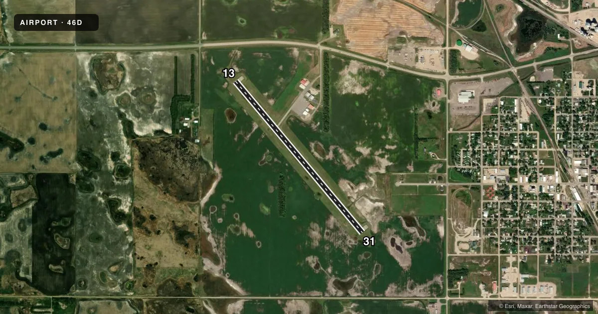
Runways & pattern
Full pagePattern entry · RWY 31
LEFT TRAFFICRunway end performance
| End | TORA | TODA | ASDA | LDA | VGSI | Approach lights | Obstruction |
|---|---|---|---|---|---|---|---|
| 13 | — | — | — | — | PAPI 2-box left(3°) | — | — |
| 31 | — | — | — | — | PAPI 2-box left(3°) | — | — |
Declared distances in feet. TORA = takeoff run available, TODA = takeoff distance, ASDA = accelerate-stop, LDA = landing distance.
Airport sketch
Runways drawn to scale from FAA survey coordinates, rendered over satellite imagery. Not for navigation.
Approaches & charts
Services on the field
Fuel grades, oxygen, maintenance, ramp storage and lighting — as declared to the FAA by the airport operator.
Fuel & services
- Fuel
- 100LL
- Oxygen (bottled)
- Not available
- Oxygen (bulk)
- Not available
- Airframe repair
- Not available
- Power plant repair
- Not available
Ramp & ground
- Transient storage
- Tie-down
- Landing fee
- No fee published
- Customs
- Not available
- Lighting schedule
- SEE RMK
- Beacon schedule
- SS-SR
- Beacon
- White / Green (civil land)(WG)
- Wind indicator
- Lighted
- Segmented circle
- Yes
Fuel & FBOs
Cheapest 100LL and Jet A on the field and nearby. Always confirm with the FBO before taxi.
Airport notes
Surface conditions, obstructions, local procedures, lighting outages and other notes published with each FAA cycle.
General notes
- FOR SNOW REMOVAL INFO CTC AMGR 701-652-5206.
- RWY 13 HAS - 6 FT DITCH 120 FT L OF EXTDD CNTRLN, 70' OUTBOUND FM THR.
- FOR CD CTC MINNEAPOLIS ARTCC AT 651-463-5588.
- BIRDS & DEER INVOF ARPT.
Lighting notes
- MIRL RY 13/31 OPER DUSK-0000, AFT 0000 ACTVT MIRL RY 13/31 & PAPI RYS 13 & 31 - CTAF.
Fuel notes
- 100LL100LL 24HR SELF SERVICE CREDIT CARD.
Other notes
- EXISTED PRIOR TO 1959.
- MANAGERADNL CTC: JAY BAUER 701-653-5312.
- MANAGERAMGR'S TEL 701-652-5206.
- OWNERJENNIFER GAST, ARPT AUTH CLERK, 701-652-2911, EXT 3.
VFR map & nearby airports
VFR sectional. Tap any ICAO chip to open that airport.
Key facts · 46D
Answer card- ICAO
- 46D
- Name
- CARRINGTON MUNI
- Location
- CARRINGTON, NORTH DAKOTA
- Elevation
- 1,606.5 ft MSL
- Traffic pattern altitude
- 2,606.5 ft MSL (1,000 AGL)
- Control tower
- Non-towered (use CTAF)
- Total runways
- 1
- Longest runway
- 13/31 · 4,198 ft
- Published ILS approaches
- 0
- Published frequencies
- 1
- Magnetic variation
- 7°
- Current flight rules
- VFR
- Current wind
- 000° at 6 kt
- Favored runway now
- RWY 31
Carrington Muni sits in Carrington, North Dakota. Field elevation is 1,606.5 ft MSL. The airport has one runway. Runway 13/31 is 4,198 ft of asphalt, so plan performance with that length in mind. There is no control tower. CTAF is 122.9.
No ILS approaches are published here. Pattern altitude is not published, so use the standard 1,000 ft AGL for light piston operations unless the current Chart Supplement says otherwise. The field has one on-field FBO, Carrington Municipal Airport. It carries AVGAS 100LL. Self-serve 100LL is available 24 hours a day by credit card.
A few local items matter on a first visit. Runway 13 has a 6-foot ditch 120 feet left of the extended centerline, 70 feet beyond the threshold. Birds and deer are in the area. Agricultural traffic is common from June through September. Runway lights on 13/31 run from dusk to 0000. After 0000, the runway lights and the PAPI on runways 13 and 31 are activated by CTAF. For clearance delivery, contact Minneapolis ARTCC. If you need snow removal or airport contact details, call the airport manager or airport authority directly.