METAR & TAF 8J7
8J7 does not publish a METAR.
Showing the nearest reporting station: KDVL (DEVILS LAKE RGNL) · 26.8 NM away. Conditions at 8J7 may differ.
METAR · KDVL
Observed 06:56Z
KDVL 260656Z AUTO 17006KT 10SM CLR 24/22 A2981 RMK AO2 SLP089 T02390222
- Wind
- 170° @ 6 kt
- Visibility
- 10 SM
- Temp / Dew
- 24°C / 22°C
- Altimeter
- 29.81 inHg
- Clouds
- CLR
- Density alt
- 3,120 ft
- Ceiling
- Unlimited
- Rules
- VFR
Airport info & contacts
Manager on record, flight service, ARTCC, attendance schedule and pattern altitude — published by the FAA and refreshed every 28 days.
Location
- From city
- 1 NM N
- VFR sectional
- TWIN CITIES
- ARTCC
- ZMP · MINNEAPOLIS
- NOTAM facility
- GFK (NOTAM-D)
Airport manager
- Name
- TROY GEORGESON
- Phone
- 701-454-6588
- Address
- 16057 83RD ST NE, DRAYTON ND 58225
Flight service · Hours
- FSS GFK
- GRAND FORKS1-800-WX-BRIEF
- Attendance
- Unattended
Frequencies
Tap any row to copy the frequency to your clipboard.
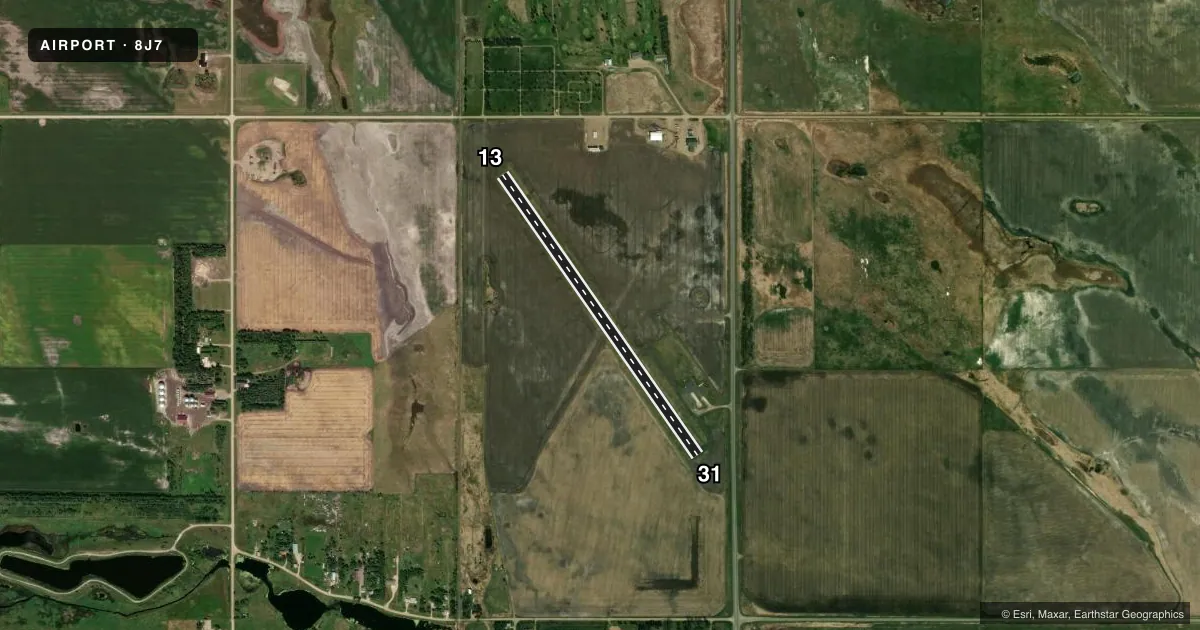
Runways & pattern
Full pagePattern entry · RWY 13
LEFT TRAFFICRunway end performance
| End | TORA | TODA | ASDA | LDA | VGSI | Approach lights | Obstruction |
|---|---|---|---|---|---|---|---|
| 13 | — | — | — | — | — | — | 6', pole, 220' from thr, 85' R of cntrln, slope 3 |
| 31 | — | — | — | — | — | — | 16', road, 430' from thr, 150' R of cntrln, slope 14 |
Declared distances in feet. TORA = takeoff run available, TODA = takeoff distance, ASDA = accelerate-stop, LDA = landing distance.
Airport sketch
Runways drawn to scale from FAA survey coordinates, rendered over satellite imagery. Not for navigation.
Approaches & charts
Services on the field
Fuel grades, oxygen, maintenance, ramp storage and lighting — as declared to the FAA by the airport operator.
Fuel & services
- Fuel
- Not available
- Oxygen (bottled)
- Not available
- Oxygen (bulk)
- Not available
- Airframe repair
- Not available
- Power plant repair
- Not available
- Other services
- AGRI
Ramp & ground
- Transient storage
- Not published
- Landing fee
- No fee published
- Customs
- Not available
- Wind indicator
- Yes
- Segmented circle
- Yes
Fuel & FBOs
Cheapest 100LL and Jet A on the field and nearby. Always confirm with the FBO before taxi.
Airport notes
Surface conditions, obstructions, local procedures, lighting outages and other notes published with each FAA cycle.
General notes
- CONFIRM SNOW REMOVAL & WINTER COND W ARPT MGR.
- FOR CD CTC MINNEAPOLIS ARTCC AT 651-463-5588.
- BIRDS & DEER INVOF AIRFIELD.
Runway surface & condition
- 13/31SW LTD TO 4000 LBS PER AMGR ON APRON ONLY.
Approach & departure obstructions
- 13+1 FT DIRT TRAIL 150 FT FM RWY END 125 FT R & ANGLES TO 300 FT FM RWY END ON CL.
- 136 FT POLES LCTD 220 FT FM THLD 85 FT EITHER SIDE OF CNTLN 3:1 SLOPE. RLRD 540 FT FM THLD 155 R OF CNTLN 14:1 CLNC SLOPE.
Other notes
- EXISTED PRIOR TO 1959.
- MANAGERADNL CTC 701-947-2461.
- AGRIFOR AGRI SVCS CALL 701-454-6588.
VFR map & nearby airports
VFR sectional. Tap any ICAO chip to open that airport.
Key facts · 8J7
Answer card- ICAO
- 8J7
- Name
- TOMLINSON FLD
- Location
- NEW ROCKFORD, NORTH DAKOTA
- Elevation
- 1,535 ft MSL
- Traffic pattern altitude
- 2,535 ft MSL (1,000 AGL)
- Control tower
- Non-towered (use CTAF)
- Total runways
- 1
- Longest runway
- 13/31 · 3,600 ft
- Published ILS approaches
- 0
- Published frequencies
- 1
- Magnetic variation
- 8°
- Current flight rules
- VFR
- Current wind
- 170° at 6 kt
- Favored runway now
- RWY 13
Tomlinson Fld sits in New Rockford, North Dakota. Field elevation is 1,533 ft MSL. The airport has one runway, 13/31 and the longest runway is 3,600 ft of asphalt. There is no control tower. CTAF is 122.9.
No ILS approaches are published here. Pattern altitude is not published in the facts, so use the current FAA Chart Supplement before you fly. The field has a few items that matter on arrival. Birds and deer are reported in the area. Snow removal and winter surface condition should be confirmed with the airport manager. Runway 13 has a dirt trail near the departure end. There is also a tree near the 13 threshold. Runway 31 has a tree near the threshold as well. The outbound threshold safety area is cultivated and rough.
There are no on-field FBOs listed in the facts. Contact the airport operator directly before arrival if you need fuel or ground support. Single-wheel gross weight is limited to 4,000 lb on the apron only, per airport manager. For clearance delivery, contact Minneapolis ARTCC at 651-463-5588. This is a small, uncontrolled North Dakota field. Plan for local traffic, winter surface issues and wildlife on or near the runway.