METAR & TAF D24
D24 does not publish a METAR.
Showing the nearest reporting station: KDVL (DEVILS LAKE RGNL) · 40.8 NM away. Conditions at D24 may differ.
METAR · KDVL
Observed 04:56Z
KDVL 270456Z AUTO 33004KT 9SM CLR 22/17 A2978 RMK AO2 SLP079 T02170167 403440217
- Wind
- 330° @ 4 kt
- Visibility
- 9 SM
- Temp / Dew
- 22°C / 17°C
- Altimeter
- 29.78 inHg
- Clouds
- CLR
- Density alt
- 3,021 ft
- Ceiling
- Unlimited
- Rules
- VFR
Airport info & contacts
Manager on record, flight service, ARTCC, attendance schedule and pattern altitude — published by the FAA and refreshed every 28 days.
Location
- From city
- 3 NM NW
- VFR sectional
- TWIN CITIES
- ARTCC
- ZMP · MINNEAPOLIS
- NOTAM facility
- GFK (NOTAM-D)
Airport manager
- Name
- MARK NELSON
- Phone
- 701-653-5069
- Address
- 833 SUNSET DRIVE, MAPLETON ND 58059
Flight service · Hours
- FSS GFK
- GRAND FORKS1-800-WX-BRIEF
- Attendance
- Unattended
Frequencies
Tap any row to copy the frequency to your clipboard.
Runways & pattern
Full pagePattern entry · RWY 26
LEFT TRAFFICRunway end performance
| End | TORA | TODA | ASDA | LDA | VGSI | Approach lights | Obstruction |
|---|---|---|---|---|---|---|---|
| 26 | — | — | — | — | — | — | 59', trees, 1500' from thr, 60' R of cntrln, slope 25 |
Declared distances in feet. TORA = takeoff run available, TODA = takeoff distance, ASDA = accelerate-stop, LDA = landing distance.
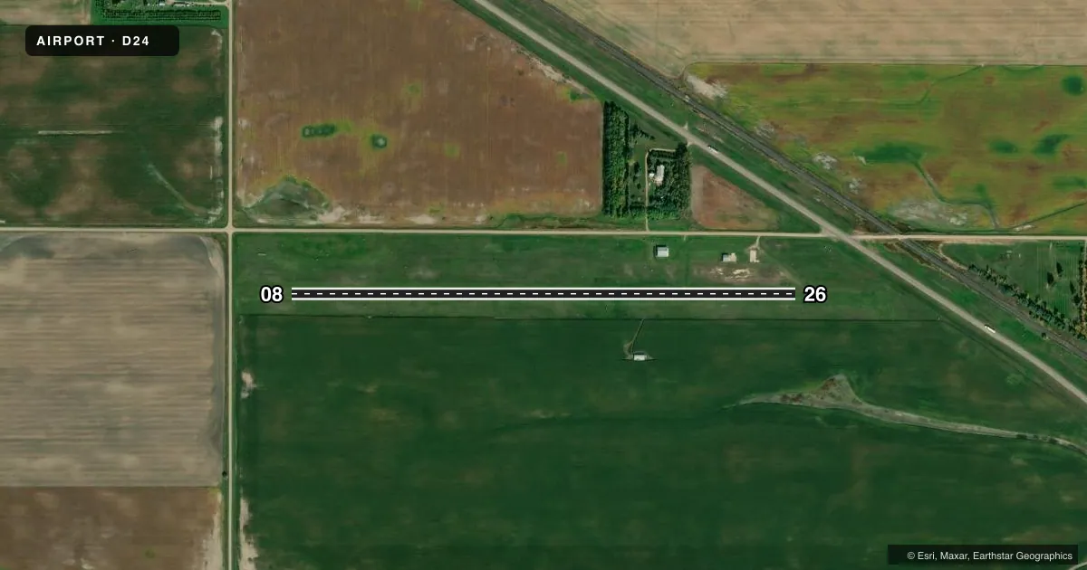
Airport sketch
Runways drawn to scale from FAA survey coordinates, rendered over satellite imagery. Not for navigation.
Approaches & charts
Services on the field
Fuel grades, oxygen, maintenance, ramp storage and lighting — as declared to the FAA by the airport operator.
Fuel & services
- Fuel
- Not available
- Other services
- AGRI
Ramp & ground
- Transient storage
- Hangar
- Landing fee
- No fee published
- Lighting schedule
- SEE RMK
- Wind indicator
- Yes
- Segmented circle
- No
Fuel & FBOs
Cheapest 100LL and Jet A on the field and nearby. Always confirm with the FBO before taxi.
Airport notes
Surface conditions, obstructions, local procedures, lighting outages and other notes published with each FAA cycle.
General notes
- NO SNOW REMOVAL AVBL - CONFIRM COND PRIOR TO USE OCT-APR.
- WATERFOWL & DEER ON & INVOF ARPT DURING MIGRATORY SEASON.
- DALGT CONE MARKERS AT RY ENDS & DSPLCD THSLDS.
- FOR CD CTC MINNEAPOLIS ARTCC AT 651-463-5588.
Lighting notes
- ACTVT LIRL RY 08/26 - CTAF.
Runway surface & condition
- 08/26RY 08 HAS LGTD 300 FT DSPLCD THSLD & RY 26 HAS 550 FT LGTD DSPLCD THSLD.
Other notes
- THLDS LCTD & MKD TO PROVIDE 20:1 APCH CLNC 125' EITHER SIDE OF CNTRLN MUST BE CLEAR OF OBSTNS; PUBLISHED LENGTH WILL BE 2940'; RY EDGE THR MARKINGS WILL BE INSTALLED.
- OWNERAPT AUTH CHRMN - MARK NELSON
- MANAGERAFTER 1700 HOURS MON-FRI & DURG SAT-SUN CTC AMGR 701-653-5069.
- AGRIFOR AGRI SVCS CALL 701-438-2444.
VFR map & nearby airports
VFR sectional. Tap any ICAO chip to open that airport.
Key facts · D24
Answer card- ICAO
- D24
- Name
- FESSENDEN-STREIBEL MUNI
- Location
- FESSENDEN, NORTH DAKOTA
- Elevation
- 1,619 ft MSL
- Traffic pattern altitude
- 2,619 ft MSL (1,000 AGL)
- Control tower
- Non-towered (use CTAF)
- Total runways
- 1
- Longest runway
- 08/26 · 2,940 ft
- Published ILS approaches
- 0
- Published frequencies
- 1
- Magnetic variation
- 9°
- Current flight rules
- VFR
- Current wind
- 330° at 4 kt
- Favored runway now
- RWY 26
Fessenden-Streibel Muni (D24) sits in Fessenden, North Dakota at 1,619 ft MSL. It has one runway. Runway 08/26 is a 2,940 ft turf strip with magnetic headings of 08 and 26. There is no control tower. CTAF is 122.9.
No ILS approaches are published here. Pattern altitude is not published, so use standard 1,000 ft AGL unless the current Chart Supplement says otherwise. The published remarks matter here. Waterfowl and deer can be on or near the airport during migratory season. No snow removal is available, so check conditions before a winter or shoulder-season arrival. Runway 08/26 also has activated low intensity runway lights on CTAF. Runway 08 has a 300 ft lighted displaced threshold. Runway 26 has a 550 ft lighted displaced threshold.
There are no on-field FBOs listed. For agricultural services, call 701-438-2444. For clearance delivery, contact Minneapolis ARTCC at 651-463-5588. After 1700 Monday through Friday, or during the weekend, contact the airport manager at 701-653-5069. If you are planning a first visit, pay close attention to the turf surface. Also note the displaced thresholds and the published obstruction clearance notes.