METAR & TAF 7G2
7G2 does not publish a METAR.
Showing the nearest reporting station: KBIS (BISMARCK MUNI) · 42.7 NM away. Conditions at 7G2 may differ.
METAR · KBIS
Observed 19:52Z
KBIS 271952Z 06006KT 10SM CLR 33/12 A2989 RMK AO2 SLP108 T03280117
- Wind
- 060° @ 6 kt
- Visibility
- 10 SM
- Temp / Dew
- 33°C / 12°C
- Altimeter
- 29.89 inHg
- Clouds
- CLR
- Density alt
- 4,553 ft
- Ceiling
- Unlimited
- Rules
- VFR
Airport info & contacts
Manager on record, flight service, ARTCC, attendance schedule and pattern altitude — published by the FAA and refreshed every 28 days.
Location
- From city
- 2 NM SW
- VFR sectional
- TWIN CITIES
- ARTCC
- ZMP · MINNEAPOLIS
- NOTAM facility
- GFK (NOTAM-D)
Airport manager
- Name
- JERRY KITTO
- Phone
- 701-220-4365
- Address
- 561 5TH AVENUE NE, MC CLUSKY ND 58463
Flight service · Hours
- FSS GFK
- GRAND FORKS1-800-WX-BRIEF
- Attendance
- Unattended
Frequencies
Tap any row to copy the frequency to your clipboard.
Runways & pattern
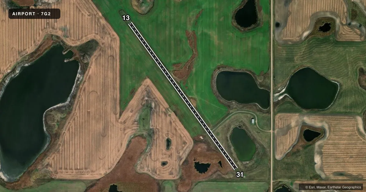
Full pagePattern entry · RWY 13
LEFT TRAFFICAirport sketch
Runways drawn to scale from FAA survey coordinates, rendered over satellite imagery. Not for navigation.
Approaches & charts
Services on the field
Fuel grades, oxygen, maintenance, ramp storage and lighting — as declared to the FAA by the airport operator.
Fuel & services
- Fuel
- Not available
- Oxygen (bottled)
- Not available
- Oxygen (bulk)
- Not available
- Airframe repair
- Not available
- Power plant repair
- Not available
Ramp & ground
- Transient storage
- Not published
- Landing fee
- No fee published
- Customs
- Not available
- Wind indicator
- No
- Segmented circle
- No
Fuel & FBOs
Cheapest 100LL and Jet A on the field and nearby. Always confirm with the FBO before taxi.
Airport notes
Surface conditions, obstructions, local procedures, lighting outages and other notes published with each FAA cycle.
General notes
- CFM IREG SNOW REMOVAL & WINTER CONDS WITH AMGR PRIOR TO USE. SNOW REMOVAL EMERG ONLY CALL 701-220-4365.
- +15' WINDSOCK 150' FM CL PENETRATES 7:1 TRANSITIONAL SFC.
- FOR CD CTC MINNEAPOLIS ARTCC AT 651-463-5588.
Other notes
- 13/31RY 13/31 HAS NMRS GRASS CLUMPS.
VFR map & nearby airports
VFR sectional. Tap any ICAO chip to open that airport.
Key facts · 7G2
Answer card- ICAO
- 7G2
- Name
- MC CLUSKY MUNI
- Location
- MC CLUSKY, NORTH DAKOTA
- Elevation
- 1,900 ft MSL
- Traffic pattern altitude
- 2,900 ft MSL (1,000 AGL)
- Control tower
- Non-towered (use CTAF)
- Total runways
- 1
- Longest runway
- 13/31 · 3,136 ft
- Published ILS approaches
- 0
- Published frequencies
- 1
- Magnetic variation
- 9°
- Current flight rules
- VFR
- Current wind
- 060° at 6 kt
- Favored runway now
- RWY 13
Mc Clusky Muni sits in Mc Clusky, North Dakota. Field elevation is 1,900 ft MSL. The airport has one runway. Runway 13/31 is 3,136 ft of turf. The published magnetic headings are 144° and 324°. There is no control tower. CTAF is 122.9. No ILS approaches are published.
Pattern altitude is not published. Use 1,000 ft AGL as the standard light aircraft pattern unless the current Chart Supplement or local procedures say otherwise. At this field, that puts the pattern at 2,900 ft MSL. The airport is small and simple, but the turf surface matters. Published remarks note numerous grass clumps on Runway 13/31. Expect a rougher roll than a paved strip. Winter use also needs a check with the airport manager. Snow removal is emergency only. Call 701-220-4365 before you go if conditions matter.
There are no on-field FBOs listed. Plan on self-sufficiency and verify services before departure. For clearance delivery, contact Minneapolis ARTCC at 651-463-5588. A windsock near the runway also penetrates the transitional surface, so keep an eye out for that when you are taxiing and landing. This is a non-towered turf field at 1,900 ft MSL. Density altitude can still matter on warm days, especially with a full load and a soft surface.