METAR & TAF D05
D05 does not publish a METAR.
Showing the nearest reporting station: KHZE (MERCER COUNTY RGNL) · 22.7 NM away. Conditions at D05 may differ.
METAR · KHZE
Observed 16:15Z
KHZE 271615Z AUTO VRB05KT 10SM CLR 27/13 A2992 RMK AO2
- Wind
- VAR @ 5 kt
- Visibility
- 10 SM
- Temp / Dew
- 27°C / 13°C
- Altimeter
- 29.92 inHg
- Clouds
- CLR
- Density alt
- 3,841 ft
- Ceiling
- Unlimited
- Rules
- VFR
Airport info & contacts
Manager on record, flight service, ARTCC, attendance schedule and pattern altitude — published by the FAA and refreshed every 28 days.
Location
- From city
- 1 NM W
- VFR sectional
- BILLINGS
- ARTCC
- ZMP · MINNEAPOLIS
- NOTAM facility
- GFK (NOTAM-D)
Airport manager
- Name
- JIM WILCOX
- Phone
- (701) 301-1055
- Address
- P.O. BOX 234, GARRISON ND 58540
Flight service · Hours
- FSS GFK
- GRAND FORKS1-800-WX-BRIEF
- Attendance
- Unattended
Frequencies
Tap any row to copy the frequency to your clipboard.
Runways & pattern
Full pagePattern entry · RWY 03
LEFT TRAFFIC| Runway | Heading (°M) | Length | Surface | Traffic |
|---|---|---|---|---|
| 13/31 | 131° / 311° | 3,699 ft | ASPH | Standard L |
| 03/21Favored | 28° / 208° | 2,618 ft | TURF | Standard L |
Runway end performance
| End | TORA | TODA | ASDA | LDA | VGSI | Approach lights | Obstruction |
|---|---|---|---|---|---|---|---|
| 13 | — | — | — | — | PAPI 2-box left(3°) | — | — |
| 31 | — | — | — | — | PAPI 2-box left(3°) | — | — |
Declared distances in feet. TORA = takeoff run available, TODA = takeoff distance, ASDA = accelerate-stop, LDA = landing distance.
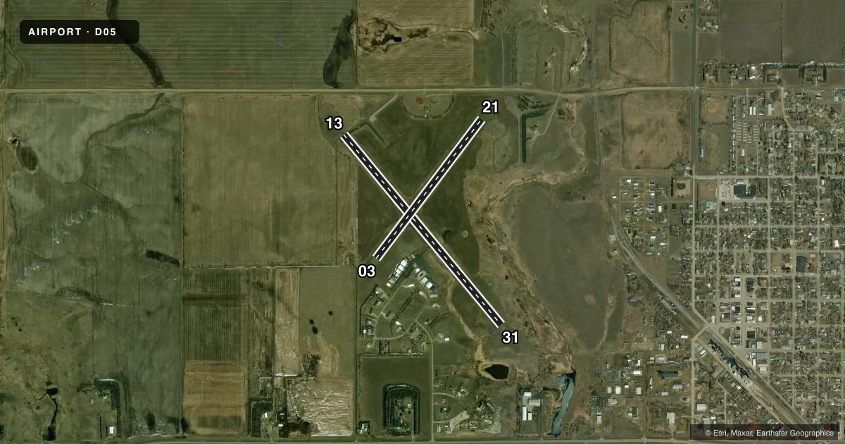
Airport sketch
Runways drawn to scale from FAA survey coordinates, rendered over satellite imagery. Not for navigation.
Approaches & charts
Services on the field
Fuel grades, oxygen, maintenance, ramp storage and lighting — as declared to the FAA by the airport operator.
Fuel & services
- Fuel
- 100LL
- Oxygen (bottled)
- Not available
- Oxygen (bulk)
- Not available
- Other services
- AGRI
Ramp & ground
- Transient storage
- Tie-down
- Landing fee
- No fee published
- Customs
- Not available
- Lighting schedule
- SEE RMK
- Beacon schedule
- SS-SR
- Beacon
- White / Green (civil land)(WG)
- Wind indicator
- Lighted
- Segmented circle
- Yes
Fuel & FBOs
Cheapest 100LL and Jet A on the field and nearby. Always confirm with the FBO before taxi.
Airport notes
Surface conditions, obstructions, local procedures, lighting outages and other notes published with each FAA cycle.
General notes
- CFM SNOW REMOVAL CTC AMGR OR CITY HALL (701) 463-2600.
- WILDLIFE AND BIRDS ON AND INVOF ARPT.
- FOR CD CTC MINNEAPOLIS ARTCC AT 651-463-5588.
Lighting notes
- ACTVT PAPI RWY 13 & 31; MIRL RWY 13/31 - CTAF.
Fuel notes
- 100LL24 HR SELF SVC CREDIT CARD FUEL AVBL.
Runway surface & condition
- 03/21RWY 03/21 CLSD WINTER MONTHS DUE TO LACK OF SNOW REMOVAL
Approach & departure obstructions
- 03+25 FT TREES 330 FT FROM RWY END 235 R OF CNTLN; PENETRATES 7:1 TRNSL SFC.
- 21+262 FT TWR 6600 FT FROM RWY END 1000 FT R.
Other notes
- MANAGERADDL CONTACT CITY 701-463-2600
VFR map & nearby airports
VFR sectional. Tap any ICAO chip to open that airport.
Key facts · D05
Answer card- ICAO
- D05
- Name
- GARRISON MUNI
- Location
- GARRISON, NORTH DAKOTA
- Elevation
- 1,936.5 ft MSL
- Traffic pattern altitude
- 2,936.5 ft MSL (1,000 AGL)
- Control tower
- Non-towered (use CTAF)
- Total runways
- 2
- Longest runway
- 13/31 · 3,699 ft
- Published ILS approaches
- 0
- Published frequencies
- 1
- Magnetic variation
- 9°
- Current flight rules
- VFR
- Current wind
- 000° at 5 kt
- Favored runway now
- RWY 03
Garrison Muni sits in Garrison, North Dakota. The field elevation is 1,936.5 ft MSL. It has two runways. The longest is 13/31 at 3,699 ft on asphalt. Runway 03/21 is turf at 2,618 ft. This is an untowered field, so traffic is on CTAF 122.9. No ILS approaches are published here. The pattern altitude is not published, so use the standard 1,000 ft AGL for light piston operations unless the current Chart Supplement says otherwise.
The on-field FBO is Garrison Municipal Airport. It carries 100LL. Twenty-four hour self-service credit card fuel is available. Runway 13 and 31 have PAPI and medium intensity lights that are controlled by CTAF. Runway 03/21 is closed during winter months because snow removal is not provided. That matters here. Plan for winter conditions and confirm snow removal with the airport manager or City Hall before you go.
There are published obstructions off both ends of runway 03/21. There are also wildlife and birds in the area. For clearance delivery, contact Minneapolis ARTCC. If you are planning a first visit, the main things to brief are the asphalt runway choice, the winter closure on 03/21 and the lack of published ILS support.