METAR & TAF Y74
Y74 does not publish a METAR.
Showing the nearest reporting station: KMOT (MINOT INTL) · 39.7 NM away. Conditions at Y74 may differ.
METAR · KMOT
Observed 12:54Z
KMOT 271254Z 26008KT 10SM CLR 21/17 A2988 RMK AO2 SLP107 T02060167
- Wind
- 260° @ 8 kt
- Visibility
- 10 SM
- Temp / Dew
- 21°C / 17°C
- Altimeter
- 29.88 inHg
- Clouds
- CLR
- Density alt
- 3,290 ft
- Ceiling
- Unlimited
- Rules
- VFR
Airport info & contacts
Manager on record, flight service, ARTCC, attendance schedule and pattern altitude — published by the FAA and refreshed every 28 days.
Location
- From city
- 1 NM S
- VFR sectional
- BILLINGS
- ARTCC
- ZMP · MINNEAPOLIS
- NOTAM facility
- GFK (NOTAM-D)
Airport manager
- Name
- RICHARD BOLKAN
- Phone
- 701-898-3144
- Address
- PO BOX 159, PARSHALL ND 58770
Flight service · Hours
- FSS GFK
- GRAND FORKS1-800-WX-BRIEF
- Attendance
- ON CALL
Frequencies
Tap any row to copy the frequency to your clipboard.
Runways & pattern
Full pagePattern entry · RWY 30
LEFT TRAFFICRunway end performance
| End | TORA | TODA | ASDA | LDA | VGSI | Approach lights | Obstruction |
|---|---|---|---|---|---|---|---|
| 12 | — | — | — | — | PAPI 2-box left(3°) | — | — |
| 30 | — | — | — | — | PAPI 2-box left(3°) | — | — |
Declared distances in feet. TORA = takeoff run available, TODA = takeoff distance, ASDA = accelerate-stop, LDA = landing distance.
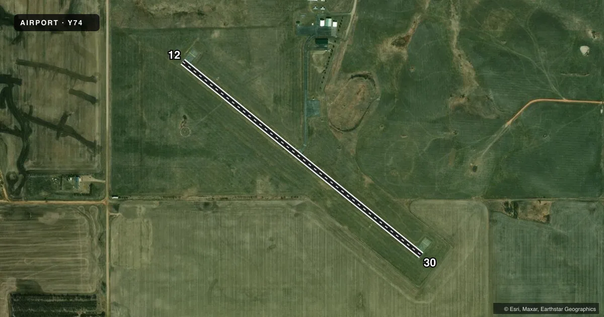
Airport sketch
Runways drawn to scale from FAA survey coordinates, rendered over satellite imagery. Not for navigation.
Approaches & charts
Services on the field
Fuel grades, oxygen, maintenance, ramp storage and lighting — as declared to the FAA by the airport operator.
Fuel & services
- Fuel
- 100LL
- Oxygen (bottled)
- Not available
- Oxygen (bulk)
- Not available
- Airframe repair
- Not available
- Power plant repair
- Not available
Ramp & ground
- Transient storage
- Tie-down
- Landing fee
- No fee published
- Customs
- Not available
- Lighting schedule
- SEE RMK
- Beacon schedule
- SS-SR
- Beacon
- White / Green (civil land)(WG)
- Wind indicator
- Lighted
- Segmented circle
- Yes
Fuel & FBOs
Cheapest 100LL and Jet A on the field and nearby. Always confirm with the FBO before taxi.
Airport notes
Surface conditions, obstructions, local procedures, lighting outages and other notes published with each FAA cycle.
General notes
- CFM SNOW REMOVAL AT 701-898-3144, OR CITY HALL 701-862-3459.
- TWY MKD WITH REFLECTORS ONLY.
- DEER & BIRDS INVOF ARPT.
- FOR CD CTC MINNEAPOLIS ARTCC AT 651-463-5588.
Lighting notes
- ACTVT PAPI RWY 12 & 30; MIRL RWY 12/30 - CTAF.
Fuel notes
- 100LLSELF SVC H24 VIA CREDIT CARD.
Other notes
- 1FOR ATNDNC SKED CALL AMGR 701-898-3144.
- MANAGERADNL CTC: CURT WITTMAYER 701-898-3504.
VFR map & nearby airports
VFR sectional. Tap any ICAO chip to open that airport.
Key facts · Y74
Answer card- ICAO
- Y74
- Name
- PARSHALL-HANKINS
- Location
- PARSHALL, NORTH DAKOTA
- Elevation
- 2,032.3 ft MSL
- Traffic pattern altitude
- 3,032.3 ft MSL (1,000 AGL)
- Control tower
- Non-towered (use CTAF)
- Total runways
- 1
- Longest runway
- 12/30 · 3,208 ft
- Published ILS approaches
- 0
- Published frequencies
- 1
- Magnetic variation
- 11°
- Current flight rules
- VFR
- Current wind
- 260° at 8 kt
- Favored runway now
- RWY 30
Parshall-Hankins Airport sits in Parshall, North Dakota. The field elevation is 2,032.3 ft MSL. It has one runway. Runway 12/30 is 3,208 ft of asphalt. There is no control tower. CTAF is 122.9.
No ILS approaches are published here. The pattern altitude is not published, so use the standard 1,000 ft AGL for light piston operations unless the current Chart Supplement says otherwise. The airport is set up for self-announce traffic. PAPI is available for runway 12 and runway 30. Medium intensity runway lights are activated on CTAF.
Parshall-Hankins Airport is on the field. It carries 100LL. Self-service 100LL is available 24 hours a day by credit card. For attendance schedule, call the airport manager. Taxiways are marked with reflectors only, so expect a simple field layout and use extra care at night or in low visibility. Deer and birds are reported in the area. Snow removal should be confirmed before winter operations. For clearance delivery, contact Minneapolis ARTCC. The airport is in a higher-elevation prairie setting, so performance planning still matters on warm days even though the runway length is workable for light aircraft.