METAR & TAF D60
Current METAR
Observed 06:15Z
KD60 240615Z AUTO 30007KT 10SM CLR 11/11 A3017 RMK AO2
- Wind
- 300° @ 7 kt
- Visibility
- 10 SM
- Temp / Dew
- 11°C / 11°C
- Altimeter
- 30.17 inHg
- Clouds
- CLR
- Density alt
- 2,026 ft
- Ceiling
- Unlimited
- Rules
- VFR
Airport info & contacts
Manager on record, flight service, ARTCC, attendance schedule and pattern altitude — published by the FAA and refreshed every 28 days.
Location
- From city
- 2 NM SE
- VFR sectional
- BILLINGS
- ARTCC
- ZMP · MINNEAPOLIS
- NOTAM facility
- GFK (NOTAM-D)
Airport manager
- Name
- JEFFERY MOE JR.
- Phone
- 701-216-0036
- Address
- P.O. BOX 428, TIOGA ND 58852
Flight service · Hours
- FSS GFK
- GRAND FORKS1-800-WX-BRIEF
- Attendance
- 0700-1700
Frequencies
Tap any row to copy the frequency to your clipboard.
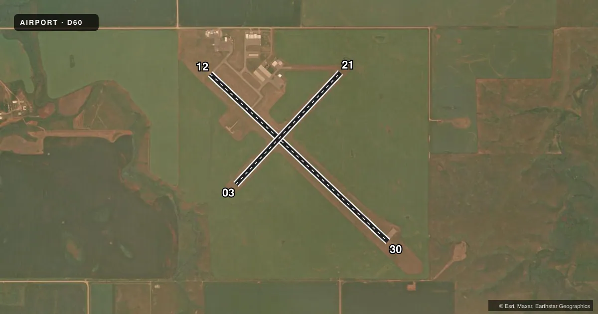
Runways & pattern
Full pagePattern entry · RWY 30
LEFT TRAFFIC| Runway | Heading (°M) | Length | Surface | Traffic |
|---|---|---|---|---|
| 12/30Favored | 125° / 305° | 5,102 ft | ASPH | Standard L |
| 03/21 | 35° / 215° | 3,200 ft | TURF | Standard L |
Runway end performance
| End | TORA | TODA | ASDA | LDA | VGSI | Approach lights | Obstruction |
|---|---|---|---|---|---|---|---|
| 12 | — | — | — | — | PAPI 2-box left(3°) | — | — |
| 30 | — | — | — | — | PAPI 2-box left(3°) | — | 29', road, 835' from thr, 340' R of cntrln, slope 21 |
Declared distances in feet. TORA = takeoff run available, TODA = takeoff distance, ASDA = accelerate-stop, LDA = landing distance.
Airport sketch
Runways drawn to scale from FAA survey coordinates, rendered over satellite imagery. Not for navigation.
Approaches & charts
Services on the field
Fuel grades, oxygen, maintenance, ramp storage and lighting — as declared to the FAA by the airport operator.
Fuel & services
- Fuel
- 100LLA+
- Oxygen (bottled)
- Not available
- Oxygen (bulk)
- Not available
- Airframe repair
- Major
- Power plant repair
- Major
- Other services
- AGRI
Ramp & ground
- Transient storage
- Tie-down
- Hangar
- Landing fee
- No fee published
- Customs
- Not available
- Lighting schedule
- SEE RMK
- Beacon schedule
- SEE RMK
- Beacon
- White / Green (civil land)(WG)
- Wind indicator
- Lighted
- Segmented circle
- Yes
Fuel & FBOs
Cheapest 100LL and Jet A on the field and nearby. Always confirm with the FBO before taxi.
Airport notes
Surface conditions, obstructions, local procedures, lighting outages and other notes published with each FAA cycle.
General notes
- NUMEROUS TOWERS APRX 2 MILES NORTH, SOUTH AND WEST OF ARPT (+236' TWR, 10,500' WEST OF RWY 12/30; +330' TOWER, 13500' SOUTH & WEST OF RWY; +612' TWR 3 MILES SOUTH & WEST OF RWY).
- CONFIRM SNOW REMOVAL WITH AMGR OR FBO AFTER MAJOR STORM.
- BIRDS & DEER ON & INVOF ARPT.
- FOR CD CTC MINNEAPOLIS ARTCC AT 651-463-5588.
Lighting notes
- ACTVT BCN - CTAF
- RY 12/30 MIRL PRESET LOW INTSTY; TO INCR INTST ACTVT PAPI RYS 12 & 30 - CTAF.
Fuel notes
- 100LLFUEL SELF SVC 24 HR CREDIT CARD ACCESS. FULL SVC PER ATTENDANT SKED AND ON CALL AFT HRS.
Approach & departure obstructions
- 03TWY & APRON MARKED WITH REFLECTORS.
- 12+230 FT TOWER 10500 FT FROM THR 5000 FT RIGHT OF EXTDD CNTRLN; +15 FT BLDG 900 FT FROM THR 100 FT LEFT OF EXTDD CNTRLN; APCH RATIO 46-1.
Other notes
- MECHANIC AVBL ON CALL. CTC FBO AT 701-664-3012.
- MECHANIC AVBL ON CALL. CONTACT FBO AT 701-664-3012.
- OWNERJEFFERY MOE JR. APT CHR; 701-216-0036
- MANAGERALTERNATE CONTACT IS STEVE JENSEN - 701-641-3417
VFR map & nearby airports
VFR sectional. Tap any ICAO chip to open that airport.
Key facts · D60
Answer card- ICAO
- D60
- Name
- TIOGA MUNI
- Location
- TIOGA, NORTH DAKOTA
- Elevation
- 2,270.8 ft MSL
- Traffic pattern altitude
- 3,270.8 ft MSL (1,000 AGL)
- Control tower
- Non-towered (use CTAF)
- Total runways
- 2
- Longest runway
- 12/30 · 5,102 ft
- Published ILS approaches
- 0
- Published frequencies
- 1
- Magnetic variation
- 8°
- Current flight rules
- VFR
- Current wind
- 300° at 7 kt
- Favored runway now
- RWY 30
Tioga Muni is in Tioga, North Dakota. The field elevation is 2,270.8 ft MSL. It has two runways. The longest is 12/30 at 5,102 ft of asphalt. Runway 03/21 is 3,200 ft of turf. There is no control tower, so use CTAF 122.9 for local traffic. The published pattern altitude is not listed. Plan on the standard 1,000 ft AGL for light piston operations unless the current Chart Supplement says otherwise.
No ILS approaches are published here. The runway 12/30 lights are medium intensity runway lights preset to low intensity. The PAPI on runways 12 and 30 is used to increase intensity through CTAF. Self-serve 100LL is available 24 hours with credit card access. Full service is available per attendant schedule and on call after hours. There is no on-field FBO listed in the facts, so verify current service details with the airport operator or the FBO directly by phone before arrival. Published remarks also note birds and deer in the area. There are several towers near the airport, including one close to the approach path on runway 12/30. That makes a careful arrival scan important, especially in low light or reduced visibility. Clearance delivery is handled through Minneapolis ARTCC when needed.