METAR & TAF 05D
05D does not publish a METAR.
Showing the nearest reporting station: KMOT (MINOT INTL) · 51.2 NM away. Conditions at 05D may differ.
METAR · KMOT
Observed 12:54Z
KMOT 271254Z 26008KT 10SM CLR 21/17 A2988 RMK AO2 SLP107 T02060167
- Wind
- 260° @ 8 kt
- Visibility
- 10 SM
- Temp / Dew
- 21°C / 17°C
- Altimeter
- 29.88 inHg
- Clouds
- CLR
- Density alt
- 3,155 ft
- Ceiling
- Unlimited
- Rules
- VFR
Airport info & contacts
Manager on record, flight service, ARTCC, attendance schedule and pattern altitude — published by the FAA and refreshed every 28 days.
Location
- From city
- 1 NM SE
- VFR sectional
- BILLINGS
- ARTCC
- ZMP · MINNEAPOLIS
- NOTAM facility
- GFK (NOTAM-D)
Airport manager
- Name
- GARRETT STUBSTAD
- Phone
- 701-421-0401
- Address
- 4413 87TH DRIVE NW, NEW TOWN ND 58763
Flight service · Hours
- FSS GFK
- GRAND FORKS1-800-WX-BRIEF
- Attendance
- Unattended
Frequencies
Tap any row to copy the frequency to your clipboard.
Runways & pattern
Full pagePattern entry · RWY 30
LEFT TRAFFICRunway end performance
| End | TORA | TODA | ASDA | LDA | VGSI | Approach lights | Obstruction |
|---|---|---|---|---|---|---|---|
| 12 | — | — | — | — | PAPI 2-box left(3°) | — | 12', rr, 200' from thr, 210' R of cntrln, slope 0 |
| 30 | — | — | — | — | PAPI 2-box left(3°) | — | 15', road, 200' from thr, 150' R of cntrln, slope 0 |
Declared distances in feet. TORA = takeoff run available, TODA = takeoff distance, ASDA = accelerate-stop, LDA = landing distance.
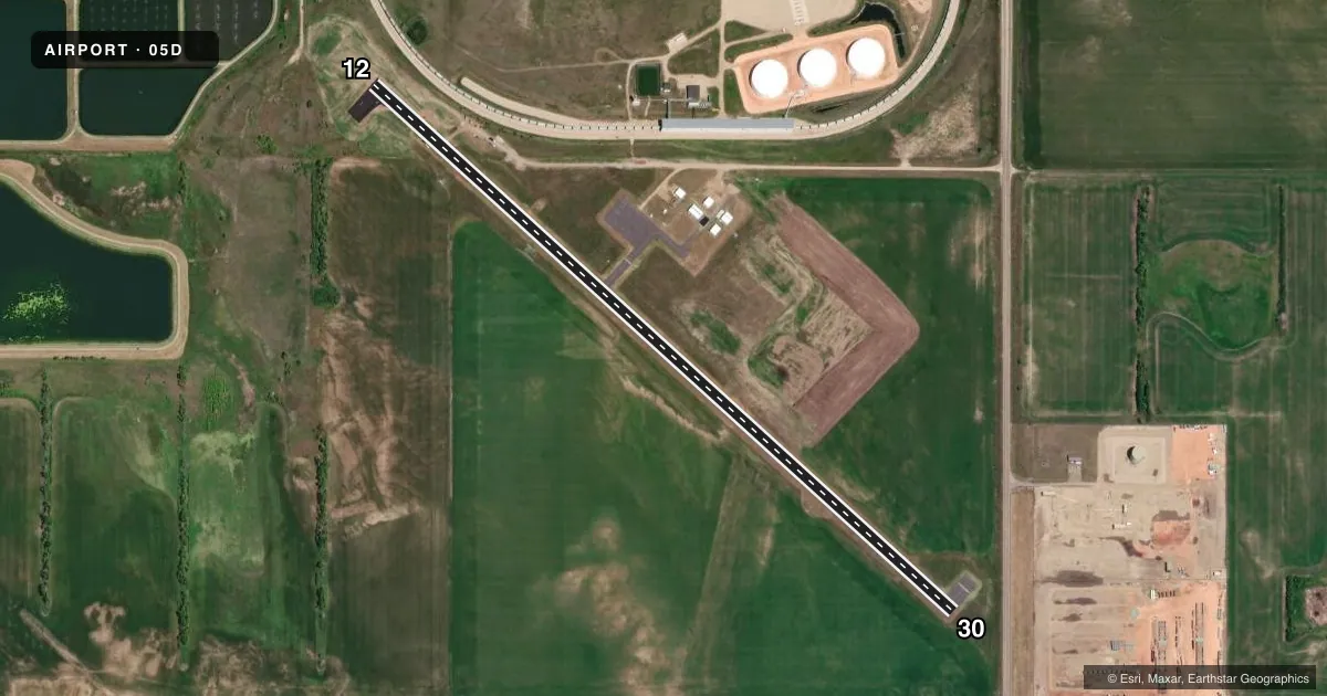
Airport sketch
Runways drawn to scale from FAA survey coordinates, rendered over satellite imagery. Not for navigation.
Approaches & charts
Services on the field
Fuel grades, oxygen, maintenance, ramp storage and lighting — as declared to the FAA by the airport operator.
Fuel & services
- Fuel
- Not available
Ramp & ground
- Transient storage
- Tie-down
- Landing fee
- No fee published
- Customs
- Not available
- Lighting schedule
- SEE RMK
- Wind indicator
- Lighted
- Segmented circle
- No
Fuel & FBOs
Cheapest 100LL and Jet A on the field and nearby. Always confirm with the FBO before taxi.
Airport notes
Surface conditions, obstructions, local procedures, lighting outages and other notes published with each FAA cycle.
General notes
- RWY 12/30 SN REMOVAL IREG; FOR RWY COND CALL 701-898-4139 OR 701-898-4918.
- BIRDS INVOF ARPT NEAR LAGOON.
- DEER ON OR INVOF ARPT.
- FOR CD CTC MINNEAPOLIS ARTCC AT 651-463-5588.
Lighting notes
- ACTVT MIRL RWY 12/30 - CTAF; RWY 12/30 PAPIS & WINDCONE ON CONSLY.
Approach & departure obstructions
- 1212 FT RR PRSNT RWY 12, 0 FT FROM CNTRLN; 220 FT L OF CNTRLN.
- 12CTLG OBSTN EXCEEDS A 45 DEG SLP.
- 30RWY 30 20:1 TO DSPLCD THR.
- 12ALSO +125 FT ELEVATORS 2800 FT FROM THR 1000 FT LEFT.
Other notes
- PRVDD RWY 30 THR DSPLCD IAW FAA AC 150/5320-13 & MKD IAW FAA AC 150/5340-1E.
- OWNERAPT CHAIRMAN GARRETT STUBSTAD
- MANAGERADDNL CTC LANGE WHITE AT 701-330-0240.
VFR map & nearby airports
VFR sectional. Tap any ICAO chip to open that airport.
Key facts · 05D
Answer card- ICAO
- 05D
- Name
- NEW TOWN MUNI
- Location
- NEW TOWN, NORTH DAKOTA
- Elevation
- 1,924 ft MSL
- Traffic pattern altitude
- 2,924 ft MSL (1,000 AGL)
- Control tower
- Non-towered (use CTAF)
- Total runways
- 1
- Longest runway
- 12/30 · 3,720 ft
- Published ILS approaches
- 0
- Published frequencies
- 1
- Magnetic variation
- 7°
- Current flight rules
- VFR
- Current wind
- 260° at 8 kt
- Favored runway now
- RWY 30
NEW TOWN MUNI sits in New Town, North Dakota. The field elevation is 1,924 ft MSL. It has one runway. Runway 12/30 is 3,720 ft long with an asphalt surface. There is no control tower. CTAF is 122.9. No ILS approaches are published here.
Pattern altitude is not published. Use 1,000 ft AGL for light piston operations unless the current Chart Supplement says otherwise. That puts the traffic pattern at 2,924 ft MSL based on the listed field elevation. Runway 12/30 has medium intensity lights that are activated by CTAF. The runway also has PAPI and a windcone on the console. Runway 30 has a displaced threshold. Runway 12 has published obstructions near the approach path, including a railroad and other tall objects. Birds and deer are reported in the area near the airport, so keep a sharp scan on arrival and departure.
No on-field FBOs are listed. Check with the airport operator or call the field directly before you go if you need fuel or services. Snow removal on runway 12/30 is irregular, so verify runway condition before a winter arrival. For clearance delivery, contact Minneapolis ARTCC. The airport is in a non-towered environment, so plan your self-announce calls and pattern work carefully.