METAR & TAF 7K5
7K5 does not publish a METAR.
Showing the nearest reporting station: KMOT (MINOT INTL) · 39.3 NM away. Conditions at 7K5 may differ.
METAR · KMOT
Observed 15:54Z
KMOT 271554Z 32010KT 10SM CLR 27/18 A2990 RMK AO2 SLP115 T02720183
- Wind
- 320° @ 10 kt
- Visibility
- 10 SM
- Temp / Dew
- 27°C / 18°C
- Altimeter
- 29.90 inHg
- Clouds
- CLR
- Density alt
- 3,898 ft
- Ceiling
- Unlimited
- Rules
- VFR
Airport info & contacts
Manager on record, flight service, ARTCC, attendance schedule and pattern altitude — published by the FAA and refreshed every 28 days.
Location
- From city
- 1 NM SE
- VFR sectional
- BILLINGS
- ARTCC
- ZMP · MINNEAPOLIS
- NOTAM facility
- GFK (NOTAM-D)
Airport manager
- Name
- DEREK PETERSON
- Phone
- 701-848-6160
- Address
- 310 6TH AVE NE, KENMARE ND 58746
Flight service · Hours
- FSS GFK
- GRAND FORKS1-800-WX-BRIEF
- Attendance
- Unattended
Frequencies
Tap any row to copy the frequency to your clipboard.
Runways & pattern
Full pagePattern entry · RWY 26
LEFT TRAFFICRunway end performance
| End | TORA | TODA | ASDA | LDA | VGSI | Approach lights | Obstruction |
|---|---|---|---|---|---|---|---|
| 08 | — | — | — | — | PAPI 2-box left(3°) | — | — |
| 26 | — | — | — | — | PAPI 2-box left(3°) | — | — |
Declared distances in feet. TORA = takeoff run available, TODA = takeoff distance, ASDA = accelerate-stop, LDA = landing distance.
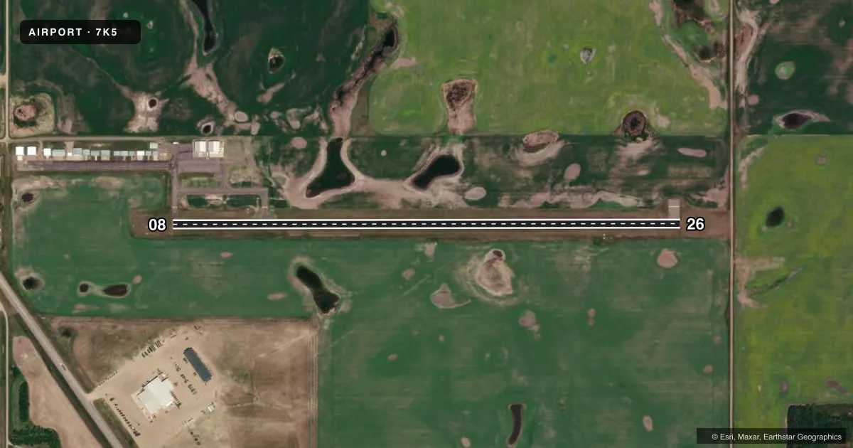
Airport sketch
Runways drawn to scale from FAA survey coordinates, rendered over satellite imagery. Not for navigation.
Approaches & charts
Services on the field
Fuel grades, oxygen, maintenance, ramp storage and lighting — as declared to the FAA by the airport operator.
Fuel & services
- Fuel
- 100LL
- Oxygen (bottled)
- Not available
- Oxygen (bulk)
- Not available
- Other services
- AGRI
Ramp & ground
- Transient storage
- Tie-down
- Landing fee
- No fee published
- Customs
- Not available
- Lighting schedule
- SEE RMK
- Beacon schedule
- SS-SR
- Beacon
- White / Green (civil land)(WG)
- Wind indicator
- Lighted
- Segmented circle
- No
Fuel & FBOs
Cheapest 100LL and Jet A on the field and nearby. Always confirm with the FBO before taxi.
Airport notes
Surface conditions, obstructions, local procedures, lighting outages and other notes published with each FAA cycle.
General notes
- CONFIRM WINTER CONDS & SNOW REMOVAL WITH AMGR 701-848-6160.
- WILDLIFE REFUGE LCTD 3500 FT W.
- WATERFOWL ON OR INVOF ARPT.
- FOR CD CTC MINNEAPOLIS ARTCC AT 651-463-5588.
Lighting notes
- ACTVT REIL RY 26; PAPI RY 08/26; MIRL RY 08/26 - CTAF. LGTS OPER FOR 1 HR AT SS.
Fuel notes
- 100LLSELF SVC FUEL AVBL H24 VIA CREDIT CARD.
Approach & departure obstructions
- 08ALSO +30 FT BLDGS 1300 FT FM THLD & 25 FT R OF EXTDD CNTRLN; +254 FT TWR 8000 FT FM THLD.
- 26CLSD ROAD 360 FT FM THLD ON EXTDD CNTRLN.
Other notes
- AGRIFOR AGRI SVC CALL (701) 848-6116.
VFR map & nearby airports
VFR sectional. Tap any ICAO chip to open that airport.
Key facts · 7K5
Answer card- ICAO
- 7K5
- Name
- KENMARE MUNI
- Location
- KENMARE, NORTH DAKOTA
- Elevation
- 1,962 ft MSL
- Traffic pattern altitude
- 2,962 ft MSL (1,000 AGL)
- Control tower
- Non-towered (use CTAF)
- Total runways
- 1
- Longest runway
- 08/26 · 3,700 ft
- Published ILS approaches
- 0
- Published frequencies
- 4
- Magnetic variation
- 10°
- Current flight rules
- VFR
- Current wind
- 320° at 10 kt
- Favored runway now
- RWY 26
Kenmare Muni sits in Kenmare, North Dakota. The field elevation is 1,962 ft MSL. It has one runway. Runway 08/26 is 3,700 ft long with an asphalt surface. There is no control tower. Pattern altitude is not published, so light piston traffic should plan on the standard 1,000 ft AGL unless the current Chart Supplement says otherwise.
No ILS approaches are published here. That makes current weather and local procedure review more important before arrival. The airport uses CTAF 122.8. UNICOM is also 122.8. For IFR clearances or approach support, Minneapolis ARTCC is listed in the remarks. The published lighting is pilot controlled on CTAF. Runway 26 has runway end identifier lights. Runways 08 and 26 have PAPI and medium intensity runway lighting. The lights operate for one hour after sunset.
Kenmare Municipal Airport is the on-field FBO. It carries AVGAS 100LL. Self-serve 100LL is available 24 hours a day by credit card. The airport remarks also call out waterfowl in or near the field. There is a wildlife refuge 3,500 ft west. That is worth keeping in mind on departure and arrival. Winter conditions and snow removal should be confirmed with the airport manager before you go.