METAR & TAF KHBC
KHBC does not publish a METAR.
Showing the nearest reporting station: KMOT (MINOT INTL) · 32.4 NM away. Conditions at KHBC may differ.
METAR · KMOT
Observed 17:54Z
KMOT 271754Z 35008KT 10SM CLR 29/18 A2989 RMK AO2 SLP112 T02940178 10294 20178 58000
- Wind
- 350° @ 8 kt
- Visibility
- 10 SM
- Temp / Dew
- 29°C / 18°C
- Altimeter
- 29.89 inHg
- Clouds
- CLR
- Density alt
- 3,763 ft
- Ceiling
- Unlimited
- Rules
- VFR
Airport info & contacts
Manager on record, flight service, ARTCC, attendance schedule and pattern altitude — published by the FAA and refreshed every 28 days.
Location
- From city
- 1 NM W
- VFR sectional
- BILLINGS
- ARTCC
- ZMP · MINNEAPOLIS
- NOTAM facility
- GFK (NOTAM-D)
Airport manager
- Name
- MIKE NEHRING
- Phone
- 701-263-1008
- Address
- PO BOX 241, MOHALL ND 58761
Flight service · Hours
- FSS GFK
- GRAND FORKS1-800-WX-BRIEF
- Attendance
- ON CALL
Frequencies
Tap any row to copy the frequency to your clipboard.
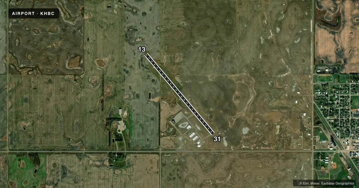
Runways & pattern
Full pagePattern entry · RWY 31
LEFT TRAFFICRunway end performance
| End | TORA | TODA | ASDA | LDA | VGSI | Approach lights | Obstruction |
|---|---|---|---|---|---|---|---|
| 13 | — | — | — | — | PAPI 2-box left(3°) | — | — |
| 31 | — | — | — | — | PAPI 2-box left(3°) | — | — |
Declared distances in feet. TORA = takeoff run available, TODA = takeoff distance, ASDA = accelerate-stop, LDA = landing distance.
Airport sketch
Runways drawn to scale from FAA survey coordinates, rendered over satellite imagery. Not for navigation.
Approaches & charts
Services on the field
Fuel grades, oxygen, maintenance, ramp storage and lighting — as declared to the FAA by the airport operator.
Fuel & services
- Fuel
- 100LLA
- Oxygen (bottled)
- Not available
- Oxygen (bulk)
- Not available
- Other services
- AGRI,INSTR
Ramp & ground
- Transient storage
- Tie-down
- Hangar
- Landing fee
- No fee published
- Customs
- Not available
- Lighting schedule
- SEE RMK
- Beacon schedule
- SS-SR
- Beacon
- White / Green (civil land)(WG)
- Wind indicator
- Lighted
- Segmented circle
- Yes
Fuel & FBOs
Cheapest 100LL and Jet A on the field and nearby. Always confirm with the FBO before taxi.
Airport notes
Surface conditions, obstructions, local procedures, lighting outages and other notes published with each FAA cycle.
General notes
- +185' TV TWR 5000' FM ARPT LCTD ON SOUTH EDGE OF TOWN.
- TO CONFIRM SNOW REMOVAL & WINTER CONDS, CALL - 701-263-1008 OR 701-263-1243.
- RWY 13 5 FT SWALE 200 FT OUTBOUND THLD.
- FOR CD CTC MINNEAPOLIS ARTCC AT 651-463-5588.
Lighting notes
- ACTVT PAPI RWY 13 & 31; MIRL RWY 13/31 - CTAF.
Fuel notes
- 100LLH24 SELF SVC WITH CREDIT CARD OR CALL AMGR CELL 701-263-1008.
- AH24 SELF SVC WITH CREDIT CARD OR CALL AMGR CELL 701-263-1008.
Approach & departure obstructions
- 1350 FT PLINE 2550 FT FM THLD ON CNTRLN EXTDD; APCH RATIO 34:1.
Other notes
- MANAGERADDTL CTC GARY ALBRIGHT 701-240-5536.
- MANAGERAMGR ADDTL PHONE 701-756-6364 OR 701-756-7258.
VFR map & nearby airports
VFR sectional. Tap any ICAO chip to open that airport.
Key facts · KHBC
Answer card- ICAO
- KHBC
- Name
- MOHALL MUNI
- Location
- MOHALL, NORTH DAKOTA
- Elevation
- 1,650.2 ft MSL
- Traffic pattern altitude
- 2,650.2 ft MSL (1,000 AGL)
- Control tower
- Non-towered (use CTAF)
- Total runways
- 1
- Longest runway
- 13/31 · 3,599 ft
- Published ILS approaches
- 0
- Published frequencies
- 4
- Magnetic variation
- 9°
- Current flight rules
- VFR
- Current wind
- 350° at 8 kt
- Favored runway now
- RWY 31
Mohall Muni sits in Mohall, North Dakota. The field elevation is 1,650.2 ft MSL. It has one runway, 13/31, which is 3,599 ft long and asphalt. There is no control tower. Use CTAF 122.8 for local traffic. No ILS approaches are published here.
The pattern altitude is not published. Use standard 1,000 ft AGL for light piston operations unless the current Chart Supplement says otherwise. The published remarks matter here. Runway 13 and runway 31 have medium intensity lights. The PAPI is active for both ends. There is also a 50-foot power line on the extended centerline for runway 13 about 2,550 ft from the threshold. A 5-foot swale sits 200 ft outbound from the runway 13 threshold. A 185-foot television tower is 5,000 ft from the airport on the south edge of town.
Fuel is available on the field. 100LL and Jet A are both listed as 24-hour self-serve with credit card access. If you need winter or snow removal status, call the airport manager before departure. For clearance delivery, contact Minneapolis ARTCC. First-time arrivals should plan for an uncontrolled field. Watch the line of obstructions on the 13 approach. Verify current conditions before going in.