METAR & TAF Y99
Y99 does not publish a METAR.
Showing the nearest reporting station: KMOT (MINOT INTL) · 30.3 NM away. Conditions at Y99 may differ.
METAR · KMOT
Observed 08:54Z
KMOT 270854Z AUTO 23004KT 10SM CLR 19/16 A2985 RMK AO2 SLP096 T01890161 51004
- Wind
- 230° @ 4 kt
- Visibility
- 10 SM
- Temp / Dew
- 19°C / 16°C
- Altimeter
- 29.85 inHg
- Clouds
- CLR
- Density alt
- 3,177 ft
- Ceiling
- Unlimited
- Rules
- VFR
Airport info & contacts
Manager on record, flight service, ARTCC, attendance schedule and pattern altitude — published by the FAA and refreshed every 28 days.
Location
- From city
- 1 NM NE
- VFR sectional
- BILLINGS
- ARTCC
- ZMP · MINNEAPOLIS
- NOTAM facility
- GFK (NOTAM-D)
Airport manager
- Name
- JAY HARSTAD
- Phone
- 701-898-3387
- Address
- 5690 67TH AVE NW, PLAZA ND 58771
Flight service · Hours
- FSS GFK
- GRAND FORKS1-800-WX-BRIEF
- Attendance
- Unattended
Frequencies
Tap any row to copy the frequency to your clipboard.
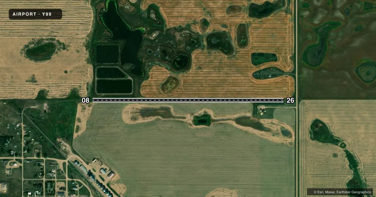
Runways & pattern
Full pagePattern entry · RWY 26
RIGHT TRAFFICRunway end performance
| End | TORA | TODA | ASDA | LDA | VGSI | Approach lights | Obstruction |
|---|---|---|---|---|---|---|---|
| 08 | — | — | — | — | — | — | 10', road, 0' from thr, 0' R of cntrln, slope 0 |
| 26 | — | — | — | — | — | — | 20', tree, 0' from thr, 55' R of cntrln, slope 0 |
Declared distances in feet. TORA = takeoff run available, TODA = takeoff distance, ASDA = accelerate-stop, LDA = landing distance.
Airport sketch
Runways drawn to scale from FAA survey coordinates, rendered over satellite imagery. Not for navigation.
Approaches & charts
Services on the field
Fuel grades, oxygen, maintenance, ramp storage and lighting — as declared to the FAA by the airport operator.
Fuel & services
- Fuel
- Not available
- Oxygen (bottled)
- Not available
- Oxygen (bulk)
- Not available
- Airframe repair
- Not available
- Power plant repair
- Not available
Ramp & ground
- Transient storage
- Not published
- Landing fee
- No fee published
- Wind indicator
- No
- Segmented circle
- No
Fuel & FBOs
Cheapest 100LL and Jet A on the field and nearby. Always confirm with the FBO before taxi.
Airport notes
Surface conditions, obstructions, local procedures, lighting outages and other notes published with each FAA cycle.
General notes
- SNOW REMOVAL IREG; CONFIRM WINTER COND WITH AMGR; CALL 701-898-3387 OR 701-453-3387; PRIOR REQUEST ONLY. SNOW REMOVAL LTD TO EMERG.
- RWY 08/26 CULTIVATED FLD 40 FT L & R OF RWY CNTRLN ENTR LEN.
- LANDFILL 2500 FT FM RWY 08 THR ON CNTRLN - BIRDS POSS.
- 15 FT TREES LCTD 50 FT S OF RWY CNTRLN, STARTING AT RWY 26 THLD.
- FOR CD CTC MINNEAPOLIS ARTCC AT 651-463-5588.
Approach & departure obstructions
- 08ROAD BEGINS AT RWY END; 10 FT TALL, ON CTRLN. SLOPE 0:1.
- 08ALSO 40+ FT TREE 795 FT FM THR & 200 FT R OF EXTD CNTRLN; ALSO 50+ FT POWERLINE APRX 1800 FT FM THR BOTH SIDES OF EXTD CNTRLN.
- 26ALSO +5 FT FENCE 100 FT FROM THR ON EXTD CNTRLN; APCH RATIO 20:1; RWY 26 ALSO +15 FT POSS VEHICLE ON ROAD 215 FT FROM THR ON EXTD CNTRLN; ALSO +10 FT POSS VEHICLE ON DRIVEWAY 115 FT LEFT OF EXTD RWY CNTRLN; ALSO +20 FT BLDG LEFT OF RWY CNTRLN APRXLY 70 FT.
Other notes
- ALL TFC OPNS ARE TO BE CONDD TO N OF RWY 8/26. ALL TURNS TO THE RGT WHEN LNDG/DPTG RWY 26; ALL TURNS TO THE L WHEN LNDG/DPTG RWY 8.
- OWNERJAY HARSTAD, CHAIRMAN OF ARPT AUTH.
- MANAGERADNL NUMBER FOR AMGR 701-453-3387. ADNL CTC TERRY REESE 701-898-3360.
- 08/26CLUMPS, ROLLS, & RUTTING ENTR LEN. DIRT MOUNDS PRSNT.
VFR map & nearby airports
VFR sectional. Tap any ICAO chip to open that airport.
Key facts · Y99
Answer card- ICAO
- Y99
- Name
- TRULSON FLD
- Location
- PLAZA, NORTH DAKOTA
- Elevation
- 2,105 ft MSL
- Traffic pattern altitude
- 3,105 ft MSL (1,000 AGL)
- Control tower
- Non-towered (use CTAF)
- Total runways
- 1
- Longest runway
- 08/26 · 3,200 ft
- Published ILS approaches
- 0
- Published frequencies
- 1
- Magnetic variation
- 11°
- Current flight rules
- VFR
- Current wind
- 230° at 4 kt
- Favored runway now
- RWY 26
Trulson Fld is in Plaza, North Dakota. The field elevation is 2,105 ft MSL. It has one runway. The longest is 3,200 ft of turf on 08/26. There is no control tower. CTAF is 122.9. No ILS approaches are published. Pattern altitude is not published, so use the current FAA Chart Supplement and local procedures before you go. For light piston traffic, the published standard is 1,000 ft AGL unless the airport says otherwise.
This is a turf strip with several items that matter on short final. Published remarks call out clumps, rolls, rutting and dirt mounds along the runway entrance. There is also a tree near the 08 end, a fence near the 26 end and other obstructions near both approaches. Traffic is to stay north of runway 08/26. Turns are right when landing or departing runway 26. Turns are left when landing or departing runway 8. Snow removal is irregular. Confirm winter conditions with the airport manager before you launch.
No on-field FBOs are listed. Check with the airport operator or the FBO directly by phone before arrival if you need services. Clearance delivery is handled through Minneapolis ARTCC at 651-463-5588. This field sits in open country. Expect a simple non-towered operation with turf performance, surface condition and obstacle clearance as the main planning items.