METAR & TAF 37N
37N does not publish a METAR.
Showing the nearest reporting station: KHZE (MERCER COUNTY RGNL) · 13.5 NM away. Conditions at 37N may differ.
METAR · KHZE
Observed 21:35Z
KHZE 242135Z AUTO 35010KT 10SM FEW039 FEW049 BKN070 21/09 A3012 RMK AO2
- Wind
- 350° @ 10 kt
- Visibility
- 10 SM
- Temp / Dew
- 21°C / 9°C
- Altimeter
- 30.12 inHg
- Clouds
- BKN
- Density alt
- 2,609 ft
- Ceiling
- 7,000 ft AGL
- Rules
- VFR
Airport info & contacts
Manager on record, flight service, ARTCC, attendance schedule and pattern altitude — published by the FAA and refreshed every 28 days.
Location
- From city
- 1 NM SW
- VFR sectional
- BILLINGS
- ARTCC
- ZMP · MINNEAPOLIS
- NOTAM facility
- GFK (NOTAM-D)
Airport manager
- Name
- KYLE WANNER
- Phone
- 701-328-9650
- Address
- PO BOX 5020, BISMARCK ND 58502
Flight service · Hours
- FSS GFK
- GRAND FORKS1-800-WX-BRIEF
- Attendance
- Unattended
Frequencies
Tap any row to copy the frequency to your clipboard.
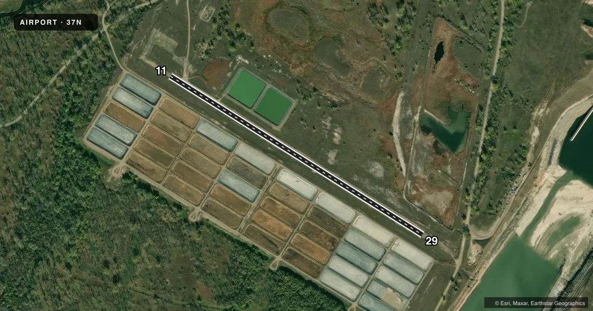
Runways & pattern
Full pagePattern entry · RWY 29
LEFT TRAFFICRunway end performance
| End | TORA | TODA | ASDA | LDA | VGSI | Approach lights | Obstruction |
|---|---|---|---|---|---|---|---|
| 11 | — | — | — | — | — | — | 50', trees, 625' from thr, 100' R of cntrln, slope 12 |
| 29 | — | — | — | — | — | — | 35', trees, 600' from thr, 155' R of cntrln, slope 17 |
Declared distances in feet. TORA = takeoff run available, TODA = takeoff distance, ASDA = accelerate-stop, LDA = landing distance.
Airport sketch
Runways drawn to scale from FAA survey coordinates, rendered over satellite imagery. Not for navigation.
Approaches & charts
Services on the field
Fuel grades, oxygen, maintenance, ramp storage and lighting — as declared to the FAA by the airport operator.
Fuel & services
- Fuel
- Not available
Ramp & ground
- Transient storage
- Tie-down
- Wind indicator
- Yes
- Segmented circle
- Yes
Fuel & FBOs
Cheapest 100LL and Jet A on the field and nearby. Always confirm with the FBO before taxi.
Airport notes
Surface conditions, obstructions, local procedures, lighting outages and other notes published with each FAA cycle.
General notes
- ARPT CLSD OCT-MAY; ARPT SFCS SOFT WHEN WET. NO SNOW REMOVAL AVBL.
- RY 11 -30 FT DROP OFF 450 FT FM THLD.
- DEER & BIRDS ON & INVOF ARPT.
- RY 29 -5 FT DROP OFF 420 FT FM THLD.
- RY 11/29 +15 FT DIRT TRAIL 40 FT FM CNTRLN ON N SIDE OF RY 500 FT INBOUND RY 11 THLD.
- FOR CD CTC MINNEAPOLIS ARTCC AT 651-463-5588.
Runway surface & condition
- 11/29SFC LMTD TO USE ONLY BY ACFT GWT UNDER 4000 LBS.
- 11/29400' DIRT/GRAVEL STWY BOTH ENDS.
Approach & departure obstructions
- 11RWY 11/29 NSTD MKGS; EDGES & THLDS MKD WITH BLACK/WHITE CONES.
- 11+3' HILL 500' FM RY END 100' R OF EXTDD CL.
- 29-3' ROAD 463' FM RY END ON EXTDD RY CL.
Other notes
- MANAGERDIRECTOR OF NORTH DAKOTA AERONAUTICS COMMISSION
- OWNERLAND LEASED BY ND AERO CMSN, PO BOX 5020, BISMARCK, ND 58502.
- MANAGERPHONE ATTENDANCE AVBL MON-FRI 0800-1700. AFT HRS CELL 701-425-5926 OR 701-955-8280.
- OWNERPHONE OF THE LOCAL CORPS OF ENGRS, RIVERDALE DIST OFC.
- 11/29NUMEROUS SMALL GRAVEL/ROCKS ON SFC.
VFR map & nearby airports
VFR sectional. Tap any ICAO chip to open that airport.
Key facts · 37N
Answer card- ICAO
- 37N
- Name
- GARRISON DAM RECREATIONAL AIRPARK
- Location
- RIVERDALE, NORTH DAKOTA
- Elevation
- 1,723 ft MSL
- Traffic pattern altitude
- 2,723 ft MSL (1,000 AGL)
- Control tower
- Non-towered (use CTAF)
- Total runways
- 1
- Longest runway
- 11/29 · 3,195 ft
- Published ILS approaches
- 0
- Published frequencies
- 1
- Magnetic variation
- 10°
- Current flight rules
- VFR
- Current wind
- 350° at 10 kt
- Favored runway now
- RWY 29
Garrison Dam Recreational Airpark sits in Riverdale, North Dakota. Field elevation is 1,723 ft MSL. The airport has one runway, 11/29, which is 3,195 ft long. It is a non-towered field. CTAF is 122.9. No ILS approaches are published here. Pattern altitude is not published, so use 1,000 ft AGL unless the current Chart Supplement says otherwise.
This is a turf-gravel runway with numerous small rocks on the surface. Runway 11 and 29 use nonstandard markings. Edges and thresholds are marked with black and white cones. The runway also has 400-foot dirt and gravel stopways at both ends. There is a 3-foot hill 500 feet from the runway end 100 feet right of the extended centerline at runway 11. There is also a 3-foot road 463 feet from the runway end on the extended centerline at runway 29. Runway 11 has a 30-foot drop off 450 feet from the threshold.
The airport is closed from October through May. Surfaces are soft when wet. No snow removal is available. That makes surface condition a real planning item here. For clearance delivery, contact Minneapolis ARTCC. Phone attendance is available Monday through Friday from 0800 to 1700. After hours, use the listed manager cell numbers. No on-field FBOs are listed, so verify services with the airport operator before you go.