METAR & TAF KHZE
Current METAR
Observed 11:55Z
KHZE 271155Z AUTO 00000KT 8SM CLR 15/11 A2994 RMK AO2
- Wind
- 000° @ 0 kt
- Visibility
- 8 SM
- Temp / Dew
- 15°C / 11°C
- Altimeter
- 29.94 inHg
- Clouds
- CLR
- Density alt
- 2,225 ft
- Ceiling
- Unlimited
- Rules
- VFR
Airport info & contacts
Manager on record, flight service, ARTCC, attendance schedule and pattern altitude — published by the FAA and refreshed every 28 days.
Location
- From city
- 2 NM E
- VFR sectional
- BILLINGS
- ARTCC
- ZMP · MINNEAPOLIS
- NOTAM facility
- GFK (NOTAM-D)
Airport manager
- Name
- STEVE FROVARP
- Phone
- (701) 748-6501
- Address
- PO BOX 507, HAZEN ND 58545
Flight service · Hours
- FSS GFK
- GRAND FORKS1-800-WX-BRIEF
- Attendance
- Unattended
Frequencies
Tap any row to copy the frequency to your clipboard.
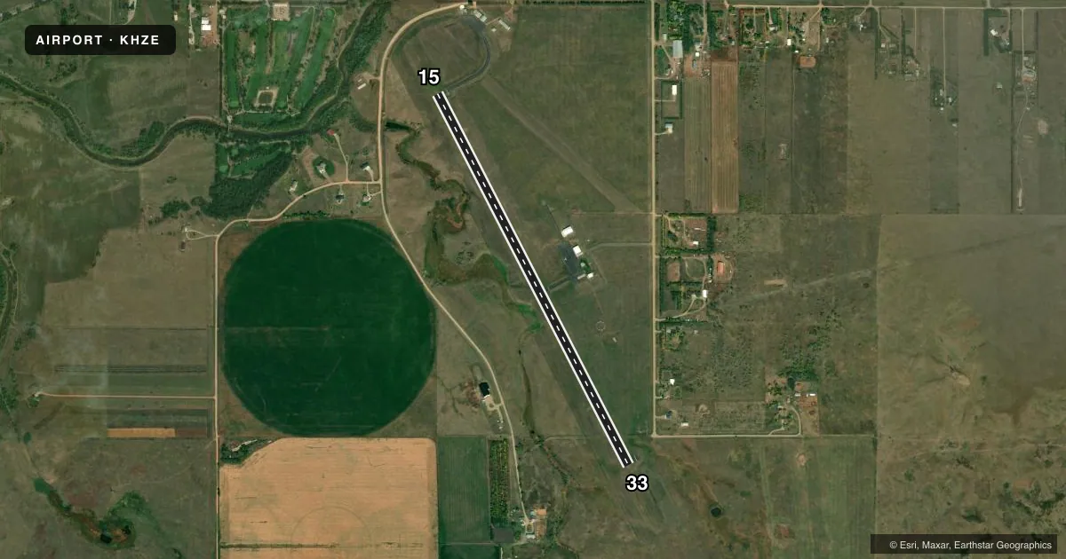
Runways & pattern
Full pagePattern entry · RWY 15
LEFT TRAFFICRunway end performance
| End | TORA | TODA | ASDA | LDA | VGSI | Approach lights | Obstruction |
|---|---|---|---|---|---|---|---|
| 15 | — | — | — | — | PAPI 2-box left(3°) | — | — |
| 33 | — | — | — | — | PAPI 2-box left(3°) | — | — |
Declared distances in feet. TORA = takeoff run available, TODA = takeoff distance, ASDA = accelerate-stop, LDA = landing distance.
Airport sketch
Runways drawn to scale from FAA survey coordinates, rendered over satellite imagery. Not for navigation.
Approaches & charts
Services on the field
Fuel grades, oxygen, maintenance, ramp storage and lighting — as declared to the FAA by the airport operator.
Fuel & services
- Fuel
- 100LLA
- Oxygen (bottled)
- Not available
- Oxygen (bulk)
- Not available
- Airframe repair
- Minor
- Power plant repair
- Minor
- Other services
- AGRI
Ramp & ground
- Transient storage
- Tie-down
- Hangar
- Landing fee
- No fee published
- Customs
- Not available
- Lighting schedule
- SEE RMK
- Beacon schedule
- SS-SR
- Beacon
- White / Green (civil land)(WG)
- Wind indicator
- Lighted
- Segmented circle
- Yes
Fuel & FBOs
Cheapest 100LL and Jet A on the field and nearby. Always confirm with the FBO before taxi.
Airport notes
Surface conditions, obstructions, local procedures, lighting outages and other notes published with each FAA cycle.
General notes
- CFM SNOW REMOVAL OCT-APR; CALL 701-880-0042.
- TRANSPORTATION SVC CALL 701-880-0042.
- 654 FT LIGHTED TOWER 3.8 NM FM THLD RY 15.
- ACFT PAINT & UPHOLSTRY SHOP AVBL CALL 701-748-5592/6714.
- BIRDS & DEER ON & INVOF ARPT.
- FOR CD IF UNA TO CTC ON FSS FREQ, CTC MINNEAPOLIS ARTCC AT 651-463-5588.
Lighting notes
- ACTVT REIL RY 33; PAPI RYS 15 & 33; & MIRL RY 15/33 - CTAF. MIRL RY 15/33 ACTVT 1/2 HR BEFORE SUNSET TO 1/2 HR AFTER SUNRISE.
Fuel notes
- 100LLSELF SVC FUEL AVBL H24 WITH CREDIT CARD.
- ASELF SVC FUEL AVBL 24 HRS WITH CREDIT CARD; FOR SINGLE POINT JET FUELING CALL 701-880-0042.
Runway surface & condition
- 15/33APRON HAS 2 CONC 20000 LB SW TIEDOWN SPACES.
Approach & departure obstructions
- 15TWY & APRON MARKED WITH REFLECTORS.
- 33TWY & APRON MARKED WITH REFLECTORS.
Other notes
- OWNERARPT MGR - STEVE FROVARP.
- MANAGERARPT MGR & CLERK OF ARPT AUTH.
- OWNERCHAIR OF ARPT AUTHORITY - RYAN VIGESAA.
- AGRIFOR KEYS TO COURTESY VEHICLE CALL 701-880-0042
VFR map & nearby airports
VFR sectional. Tap any ICAO chip to open that airport.
Key facts · KHZE
Answer card- ICAO
- KHZE
- Name
- MERCER COUNTY RGNL
- Location
- HAZEN, NORTH DAKOTA
- Elevation
- 1,814.7 ft MSL
- Traffic pattern altitude
- 2,814.7 ft MSL (1,000 AGL)
- Control tower
- Non-towered (use CTAF)
- Total runways
- 1
- Longest runway
- 15/33 · 4,999 ft
- Published ILS approaches
- 0
- Published frequencies
- 2
- Magnetic variation
- 6°
- Current flight rules
- VFR
- Current wind
- 000° at 0 kt
- Favored runway now
- –
Mercer County Rgnl is in Hazen, North Dakota. The field elevation is 1,814.7 ft MSL. It has one runway. Runway 15/33 is 4,999 ft long and asphalt. The airport is non-towered. CTAF and UNICOM are both 122.8.
No ILS approaches are published here. Runway 15/33 has medium intensity lighting. The lights are CTAF controlled. Runway 33 has REILs. Runways 15 and 33 have PAPI. The published remarks also note a 654-foot lighted tower 3.8 NM from the threshold of runway 15. Birds and deer are reported on and near the airport, so keep a sharp scan on arrival and departure.
The published pattern altitude is not listed. Use the current FAA Chart Supplement before you fly. Mercer County Regional Airport is the on-field FBO. It carries 100LL and Jet A Prist. Self-serve fuel is available 24 hours with a credit card. For single-point jet fueling, call the field directly at (701) 880-0042. Snow removal is also something to confirm from October through April. The airport manager is Steve Frovarp. If you need the courtesy vehicle, call ahead for the key.