METAR & TAF Y19
Current METAR
Observed 18:35Z
KY19 271835Z AUTO 04008G15KT 10SM CLR 31/17 A2992 RMK AO2
- Wind
- 040° @ 8G15 kt
- Visibility
- 10 SM
- Temp / Dew
- 31°C / 17°C
- Altimeter
- 29.92 inHg
- Clouds
- CLR
- Density alt
- 4,331 ft
- Ceiling
- Unlimited
- Rules
- VFR
Airport info & contacts
Manager on record, flight service, ARTCC, attendance schedule and pattern altitude — published by the FAA and refreshed every 28 days.
Location
- From city
- 4 NM S
- VFR sectional
- TWIN CITIES
- ARTCC
- ZMP · MINNEAPOLIS
- NOTAM facility
- GFK (NOTAM-D)
Airport manager
- Name
- LINDSAY GERHARDT
- Phone
- 701-663-0669
- Address
- BOX 250, MANDAN ND 58554
Flight service · Hours
- FSS GFK
- GRAND FORKS1-800-WX-BRIEF
- Attendance
- MON-FRI · 0700-1900
- SAT-SUN · ON CALL
Frequencies
Tap any row to copy the frequency to your clipboard.
Runways & pattern
Full pagePattern entry · RWY 04
LEFT TRAFFIC| Runway | Heading (°M) | Length | Surface | Traffic |
|---|---|---|---|---|
| 13/31 | 139° / 319° | 4,399 ft | CONC | Standard L |
| 04/22Favored | 49° / 229° | 2,921 ft | TURF | Standard L |
Runway end performance
| End | TORA | TODA | ASDA | LDA | VGSI | Approach lights | Obstruction |
|---|---|---|---|---|---|---|---|
| 13 | — | — | — | — | PAPI 2-box left(3°) | — | — |
| 31 | — | — | — | — | PAPI 2-box left(3°) | — | — |
Declared distances in feet. TORA = takeoff run available, TODA = takeoff distance, ASDA = accelerate-stop, LDA = landing distance.
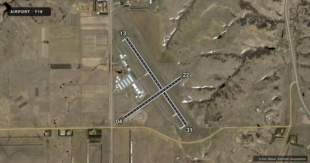
Airport sketch
Runways drawn to scale from FAA survey coordinates, rendered over satellite imagery. Not for navigation.
Approaches & charts
Services on the field
Fuel grades, oxygen, maintenance, ramp storage and lighting — as declared to the FAA by the airport operator.
Fuel & services
- Fuel
- 100LL
- Airframe repair
- Major
- Power plant repair
- Major
- Other services
- AGRI,CHTR,INSTR,RNTL,SALES,SURV
Ramp & ground
- Transient storage
- Tie-down
- Hangar
- Landing fee
- No fee published
- Customs
- Not available
- Lighting schedule
- SEE RMK
- Beacon schedule
- SS-SR
- Beacon
- White / Green (civil land)(WG)
- Wind indicator
- Lighted
- Segmented circle
- Yes
Fuel & FBOs
Cheapest 100LL and Jet A on the field and nearby. Always confirm with the FBO before taxi.
Airport notes
Surface conditions, obstructions, local procedures, lighting outages and other notes published with each FAA cycle.
General notes
- CFM SN REMOVAL AFT MAJOR WINT STORMS WITH AMGR 701-663-0669 OR 701-955-3328.
- +200 FT TWR LCTD 9500 FT NW OF RWY 13/31.
- 120 FT TWR LCTD 5000 FT SW OF RWY 04/22.
- FOR CD CTC BISMARCK APCH AT 701-223-8790.
Lighting notes
- MIRL RY 13/31 & RY 04/22 PRESET ON MED TO INCR INTST & ACTVT - CTAF; ACTVT REIL RY 13/31; & PAPI RY 13/31 - CTAF.
Fuel notes
- 100LLFOR 100LL FUEL 24 HR SELF SVC WITH CREDIT CARD OR CALL AMGR CELL PHONE 701-955-3328.
Approach & departure obstructions
- 04RWY 4 10 FT FENCE 366 FT FR THR APCH RATIO 26:1; ROAD 480 FT FR RWY 4 THR APCH RATIO 28:1.
- 13RWY 13 44 FT TREES 1250 FT FR THR APCH RATIO 23:1.
Other notes
- MANAGERAMGR CELL PHONE 701-955-3328.
VFR map & nearby airports
VFR sectional. Tap any ICAO chip to open that airport.
Key facts · Y19
Answer card- ICAO
- Y19
- Name
- MANDAN RGNL/LAWLER FLD
- Location
- MANDAN, NORTH DAKOTA
- Elevation
- 1,944 ft MSL
- Traffic pattern altitude
- 2,944 ft MSL (1,000 AGL)
- Control tower
- Non-towered (use CTAF)
- Total runways
- 2
- Longest runway
- 13/31 · 4,399 ft
- Published ILS approaches
- 0
- Published frequencies
- 4
- Magnetic variation
- 6°
- Current flight rules
- VFR
- Current wind
- 040° at 8 kt
- Favored runway now
- RWY 04
Mandan Rgnl/Lawler Fld sits in Mandan, North Dakota at 1,944 ft MSL. It has two runways. The longest is 13/31 at 4,399 ft concrete. The other runway is 04/22 at 2,921 ft turf. There is no control tower, so expect non-towered traffic flow on CTAF 122.8 and UNICOM 122.8. Published approach support does not include an ILS, so plan with the current chart and weather before you go.
Pattern altitude is not published in the facts. Use the standard 1,000 ft AGL pattern unless the current FAA Chart Supplement says otherwise. The field is served by Mandan Regional Airport, which carries 100LL. The published remarks say 24-hour self-serve fuel is available with a credit card. They also note the airport manager can be reached by cell if you need help with fuel or snow removal after a major winter storm.
There are a few things a first-time pilot should brief. Runway 13 has trees near the approach path. Runway 04 has a fence and a road close to the threshold. Runway lights on both runways are pilot-controlled through CTAF. The PAPI on 13/31 is also activated that way. Bismarck Approach handles clearance delivery. Check the current FAA Chart Supplement for any updated local procedures before you launch.