METAR & TAF 7L2
Current METAR
Observed 16:55Z
K7L2 271655Z AUTO 02007KT 9SM CLR 29/14 A2992 RMK AO2
- Wind
- 020° @ 7 kt
- Visibility
- 9 SM
- Temp / Dew
- 29°C / 14°C
- Altimeter
- 29.92 inHg
- Clouds
- CLR
- Density alt
- 3,885 ft
- Ceiling
- Unlimited
- Rules
- VFR
Airport info & contacts
Manager on record, flight service, ARTCC, attendance schedule and pattern altitude — published by the FAA and refreshed every 28 days.
Location
- From city
- 3 NM SSE
- VFR sectional
- TWIN CITIES
- ARTCC
- ZMP · MINNEAPOLIS
- NOTAM facility
- 7L2 (NOTAM-D)
Airport manager
- Name
- TRAVIS DOCKTER
- Phone
- 701-321-0173
- Address
- PO BOX 301, LINTON ND 58552
Flight service · Hours
- FSS GFK
- GRAND FORKS1-800-WX-BRIEF
- Attendance
- MON-FRI · 0800-1730
- ON CALL
Frequencies
Tap any row to copy the frequency to your clipboard.
Runways & pattern
Full pagePattern entry · RWY 09
LEFT TRAFFICRunway end performance
| End | TORA | TODA | ASDA | LDA | VGSI | Approach lights | Obstruction |
|---|---|---|---|---|---|---|---|
| 09 | — | — | — | — | PAPI 2-box left(3°) | — | — |
| 27 | — | — | — | — | PAPI 2-box left(3°) | — | — |
Declared distances in feet. TORA = takeoff run available, TODA = takeoff distance, ASDA = accelerate-stop, LDA = landing distance.
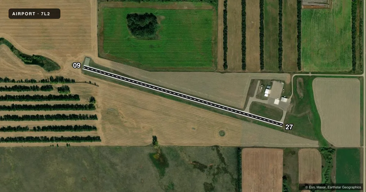
Airport sketch
Runways drawn to scale from FAA survey coordinates, rendered over satellite imagery. Not for navigation.
Approaches & charts
Services on the field
Fuel grades, oxygen, maintenance, ramp storage and lighting — as declared to the FAA by the airport operator.
Fuel & services
- Fuel
- 100LLA
- Oxygen (bottled)
- Not available
- Oxygen (bulk)
- Not available
- Airframe repair
- Not available
- Power plant repair
- Not available
- Other services
- AGRI,INSTR
Ramp & ground
- Transient storage
- Tie-down
- Hangar
- Landing fee
- No fee published
- Customs
- Not available
- Lighting schedule
- SEE RMK
- Beacon schedule
- SS-SR
- Beacon
- White / Green (civil land)(WG)
- Wind indicator
- Lighted
- Segmented circle
- Yes
Fuel & FBOs
Cheapest 100LL and Jet A on the field and nearby. Always confirm with the FBO before taxi.
Airport notes
Surface conditions, obstructions, local procedures, lighting outages and other notes published with each FAA cycle.
General notes
- CONFIRM WINTER COND BEFORE USE WITH AMGR 701-321-0173 OR 254-5449.
- DEER AND BIRDS ON & INVOF ARPT.
- FOR CD CTC MINNEAPOLIS ARTCC AT 651-463-5588.
Lighting notes
- ACTVT MIRL RY 09/27 & PAPI RYS 09 & 27 - CTAF.
Fuel notes
- 100LLSELF SERVICE 24 HOUR CREDIT CARD FUEL SYSTEM AVAILABLE.
Approach & departure obstructions
- 09RWY 27; 34 FT TREES 975 FT FROM THR APCH RATIO 22:1.
Other notes
- 2FOR ASSISTANCE, CTC AMGR: TRAVIS DOCKTER 701-321-0173
- MANAGERADDNL PHONE 701-254-5449
VFR map & nearby airports
VFR sectional. Tap any ICAO chip to open that airport.
Key facts · 7L2
Answer card- ICAO
- 7L2
- Name
- LINTON MUNI
- Location
- LINTON, NORTH DAKOTA
- Elevation
- 1,778.6 ft MSL
- Traffic pattern altitude
- 2,778.6 ft MSL (1,000 AGL)
- Control tower
- Non-towered (use CTAF)
- Total runways
- 1
- Longest runway
- 09/27 · 3,700 ft
- Published ILS approaches
- 0
- Published frequencies
- 1
- Magnetic variation
- 6°
- Current flight rules
- VFR
- Current wind
- 020° at 7 kt
- Favored runway now
- RWY 09
Linton Muni sits in Linton, North Dakota. Field elevation is 1,778.6 ft MSL. The airport has one runway. Runway 09/27 is 3,700 ft long and asphalt. There is no control tower. CTAF is 122.9. No ILS approaches are published here.
Pattern altitude is not published. Use standard 1,000 ft AGL for light piston traffic unless the current Chart Supplement says otherwise. The runway has medium intensity lighting. PAPI is available on both ends of runway 09/27. For clearance delivery, contact Minneapolis ARTCC at 651-463-5588. Deer and birds are reported on and near the airport, so keep a sharp scan on climbout and in the pattern. Runway 27 also has trees 975 ft from the threshold, so plan your approach with that in mind.
North Central Aviation is on the field. It carries AVGAS 100LL and Jet A. Self-serve 100LL is available 24 hours with credit card payment. If you are arriving in winter, confirm conditions with the airport manager before you go. This is a non-towered field in open country, so expect self-announce traffic and keep your ears up on CTAF.